- My Forums
- Tiger Rant
- LSU Recruiting
- SEC Rant
- Saints Talk
- Pelicans Talk
- More Sports Board
- Coaching Changes
- Fantasy Sports
- Golf Board
- Soccer Board
- O-T Lounge
- Tech Board
- Home/Garden Board
- Outdoor Board
- Health/Fitness Board
- Movie/TV Board
- Book Board
- Music Board
- Political Talk
- Money Talk
- Fark Board
- Gaming Board
- Travel Board
- Food/Drink Board
- Ticket Exchange
- TD Help Board
Customize My Forums- View All Forums
- Show Left Links
- Topic Sort Options
- Trending Topics
- Recent Topics
- Active Topics
Started By
Message
 2
2


Posted on 3/29/22 at 3:51 pm to Sao
Posted on 3/29/22 at 3:53 pm to TDsngumbo
quote:
URGENT - WEATHER MESSAGE National Weather Service Lake Charles LA 348 PM CDT Tue Mar 29 2022 LAZ029-032-033-043>045-052>055-300500- /O.NEW.KLCH.HW.W.0001.220330T1600Z-220330T2200Z/ /O.EXT.KLCH.WI.Y.0011.000000T0000Z-220330T1600Z/
Avoyelles-Evangeline-St. Landry-Acadia-Lafayette-Upper St. Martin- Vermilion-Iberia-St. Mary-Lower St. Martin- Including the cities of Effie, Marksville, Bunkie, Cottonport, Simmesport, Mansura, Ville Platte, Beaver, St. Landry, Mamou, Reddell, Lawtell, Opelousas, Eunice, Crowley, Rayne, Branch, Church Point, Richard, Lafayette, Breaux Bridge, Cade, St. Martinville, Abbeville, Intracoastal City, Meaux, Forked Island, Kaplan, New Iberia, Morgan City, Burns Point, Centerville, Franklin, Patterson, Berwick, Bayou Vista, and Stephensville
348 PM CDT Tue Mar 29 2022
...WIND ADVISORY NOW IN EFFECT UNTIL 11 AM CDT WEDNESDAY... ...HIGH WIND WARNING IN EFFECT FROM 11 AM TO 5 PM CDT WEDNESDAY... *
WHAT...For the High Wind Warning, south winds 20 to 30 mph with gusts up to 55 mph possible. For the Wind Advisory, south winds 15 to 25 mph with gusts up to 35 mph. *
WHERE...Avoyelles, Evangeline, St. Landry, Acadia, Lafayette, Upper St. Martin, Vermilion, Iberia, St. Mary and Lower St. Martin Parishes. * WHEN...For the High Wind Warning, from 11 AM to 5 PM CDT Wednesday.
For the Wind Advisory, until 11 AM CDT Wednesday. *
IMPACTS...Damaging winds will blow down trees and power lines. Widespread power outages are expected. Travel will be difficult, especially for high profile vehicles.
PRECAUTIONARY/PREPAREDNESS ACTIONS... People should avoid being outside in forested areas and around trees and branches. If possible, remain in the lower levels of your home during the windstorm, and avoid windows. Use caution if you must drive. &&
Posted on 3/29/22 at 3:53 pm to Duke
quote:
This is probably up because of Ida recovery and the tornado recovery the other night given the region selected as there isnt a reason the winds would be significantly higher here vs BR or Northshore.
I was in Thibodaux, Houma, and Chackbay this weekend and was surprised to see how many piles of debris are still along the roadways. Lots of recovery and cleanup left to do down there.
Posted on 3/29/22 at 3:54 pm to TDsngumbo
Yep.
Its like how heat advisory criteria drops when you have a bunch of folks without power after a hurricane.
Its like how heat advisory criteria drops when you have a bunch of folks without power after a hurricane.
Posted on 3/29/22 at 3:57 pm to Duke
I understand the high wind warning, but the 'power outages are expected' part I'm not sure. 90% of the power poles down here in Lafourche / Terrebonne were replaced after Ida and all the weak tree limbs are gone.
Sounds like basically a Tropical Storm.
Many people still have tarps and an unrepaired roof. Not ideal.
Sounds like basically a Tropical Storm.
Many people still have tarps and an unrepaired roof. Not ideal.
quote:
URGENT - WEATHER MESSAGE
National Weather Service New Orleans LA
305 PM CDT Tue Mar 29 2022
LAZ056>061-063>070-077-078-300415-
/O.UPG.KLIX.WI.Y.0008.220330T1300Z-220331T0200Z/
/O.NEW.KLIX.HW.W.0001.220330T1300Z-220331T0200Z/
Assumption-St. James-St. John The Baptist-Upper Lafourche-
St. Charles-Upper Jefferson-Upper Plaquemines-Upper St. Bernard-
Upper Terrebonne-Lower Terrebonne-Lower Lafourche-Lower Jefferson-
Lower Plaquemines-Lower St. Bernard-Western Orleans-
Eastern Orleans-
Including the cities of Pierre Part, Labadieville,
Paincourtville, Convent, Lutcher, Gramercy, Laplace, Reserve,
Thibodaux, Raceland, Larose, Destrehan, Norco, Metairie, Kenner,
Belle Chasse, Chalmette, Violet, Houma, Bayou Cane, Chauvin,
Cocodrie, Dulac, Montegut, Galliano, Cut Off, Golden Meadow,
Leeville, Grand Isle, Buras, Pointe A La Hache, Port Sulphur,
Boothville, Venice, Empire, Myrtle Grove, Yscloskey, New Orleans,
and East New Orleans
305 PM CDT Tue Mar 29 2022
...HIGH WIND WARNING IN EFFECT FROM 8 AM TO 9 PM CDT WEDNESDAY...
* WHAT...South winds 30 to 40 mph with gusts up to 50 mph
expected.
* WHERE...Portions of southeast Louisiana.
* WHEN...From 8 AM to 9 PM CDT Wednesday.
* IMPACTS...Damaging winds will blow down trees and power lines.
Power outages are expected. Travel will be difficult, especially
for high profile vehicles.
* ADDITIONAL DETAILS...Strongest winds are likely to be just in
advance of thunderstorms Wednesday afternoon.
PRECAUTIONARY/PREPAREDNESS ACTIONS...
People should avoid being outside in forested areas and around
trees and branches. If possible, remain in the lower levels of
your home during the windstorm, and avoid windows. Use caution if
you must drive.

Posted on 3/29/22 at 3:57 pm to Duke
quote:
that SE Miss/SW Ala area
Meet the new boss, same as the old boss

Posted on 3/29/22 at 3:59 pm to NorthEndZone
The power outage language is overdone. I expect there to be some but not widespread or anything.
Posted on 3/29/22 at 3:59 pm to paperwasp
Tornado alley sure appears to have shifted from when I was growing up. The worst tornados nowadays seem to be in the Dixie south 8/10 times.

Posted on 3/29/22 at 4:00 pm to LegendInMyMind
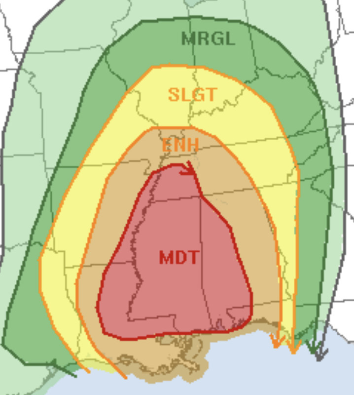
quote:
Unfortunately, for your area and a bit West, the parameters will maximize into the late night/early morning. That is why there is only a Slight Risk back in Oklahoma. Don't get lulled by placement of the risk level. You're caught in the time gap between days.
I thought the ground temps cooling off lowed tornado risk.
I’m never going to get this right.
Posted on 3/29/22 at 4:01 pm to Duke
Y’all are only thinking of the shite that fell all the way in Ida. There’s a ton of cracked trees and limbs that appear to be healthy but just waiting for a 40mph wind to hit it from the right direction to come crashing down. Just last week when we had 35-40mph gusts, I had a big arse limb that came down and there were two decent sized trees that came down down the road from me. Lots can come down in 40-50mph winds spread out over four or five hours.
This post was edited on 3/29/22 at 4:03 pm
Posted on 3/29/22 at 4:01 pm to LSUGrrrl
They reduce the risk being cooler, but dont eliminate it especially with a bunch of shear.
Posted on 3/29/22 at 4:03 pm to Duke
quote:
I expect there to be some but not widespread or anything.
That seems reasonable. I think the areas that did not have the extreme winds for Ida will be more likely to lose power but will still be spotty outages (hopefully).
Posted on 3/29/22 at 4:08 pm to Sao
I just got the most random craving for Arbys
Posted on 3/29/22 at 4:12 pm to deltaland
Posted on 3/29/22 at 4:12 pm to deltaland
as expected... the High Wind Warning has come out
I got it in Alexandria
I got it in Alexandria
Posted on 3/29/22 at 4:12 pm to LSUGrrrl
Tigerdroppings is the reason I haven’t eaten a roast beef sandwich in 8 years.
Posted on 3/29/22 at 4:15 pm to LSUGrrrl
quote:
Tigerdroppings is the reason I haven’t eaten a roast beef sandwich in 8 years.
are we talking about eati...
quote:
LSUGrrrl
nevermind

Posted on 3/29/22 at 4:16 pm to LSUGrrrl
quote:
Tigerdroppings is the reason I haven’t eaten a roast beef sandwich in 8 years.
Why?
Posted on 3/29/22 at 4:16 pm to rt3
quote:
are we talking about eati...
Kinda

 Page 12 of 92

Popular
Back to top