- My Forums
- Tiger Rant
- LSU Recruiting
- SEC Rant
- Saints Talk
- Pelicans Talk
- More Sports Board
- Fantasy Sports
- Golf Board
- Soccer Board
- O-T Lounge
- Tech Board
- Home/Garden Board
- Outdoor Board
- Health/Fitness Board
- Movie/TV Board
- Book Board
- Music Board
- Political Talk
- Money Talk
- Fark Board
- Gaming Board
- Travel Board
- Food/Drink Board
- Ticket Exchange
- TD Help Board
Customize My Forums- View All Forums
- Show Left Links
- Topic Sort Options
- Trending Topics
- Recent Topics
- Active Topics
Started By
Message
 0
0

Posted on 6/8/24 at 6:44 pm to Havoc
and they cut down all the cypress forests
Posted on 6/9/24 at 4:53 am to soccerfüt
Will it not just create more marsh though further north? Like Houma would be equivalent Last Island in 100 years. So not really a net loss, just pushing it up more north
In addition, isn't there more marsh being added now in the Atchafalya Bay I believe, so is it not a net zero equal out?
In addition, isn't there more marsh being added now in the Atchafalya Bay I believe, so is it not a net zero equal out?
This post was edited on 6/9/24 at 6:34 am
Posted on 6/9/24 at 5:00 am to MrBobDobalina
quote:
Others managed to survive by digging their feet and legs into the sand and huddling in groups in an attempt to avoid being swept off the island by the storm surge. It still sounds unbelievable to me that they were able to survive as the island was underwater for the duration of the storm
Our boat got caught in shallow water marsh near there a little north, so we had to get out and push it. Each step my feet sunk 2 feet in the mud. If I really wanted to, I bet I could've gotten to my upper thigh deep. It would've been hard for anything to push me out. The danger here I feel is the storm surge rising above head level to where you drown.
Posted on 6/9/24 at 6:53 am to Trevaylin
Truly is a telling example of the times. The government rather try to spend billions and billions of dollars to reinvent the wheel instead of do the obvious solutions.
100% donaldsonville Mississippi River damn should be step number one.
100% donaldsonville Mississippi River damn should be step number one.
Posted on 6/9/24 at 6:59 am to Bob Sacamano 89
They doing a major project over there in donaldsonville right now I believe it’s to increase the flow
Posted on 6/9/24 at 7:05 am to Tarps99
quote:
The Hurricane of 1856, Louisiana's First Great Storm
Unpossible! The Leftys told me major hurricanes just started destroying mandmade dwellings--because muh "Climate Change"!
Posted on 6/9/24 at 7:23 am to Saunson69
quote:
Will it not just create more marsh though further north? Like Houma would be equivalent Last Island in 100 years. So not really a net loss, just pushing it up more north In addition, isn't there more marsh being added now in the Atchafalya Bay I believe, so is it not a net zero equal out?
Read up on “ subsidence “. We are on a deltaic plain. We are sinking.
The Atchafalaya and Wax Lake Outlet are building some new land. BFD, it’s not enough. You can’t replicate the geologic time line and move the material needed that the Mississippi River did running at full bore in fifty years. Do the math. It doesn’t add.
Posted on 6/9/24 at 7:26 am to charliemurphy69
quote:
They doing a major project over there in donaldsonville right now I believe it’s to increase the flow
That extra flow is primarily to increase the sustainability of fresh water for the water systems that get water from Bayou Lafourche: Assumption, Lafourche, City of Thibodaux, and Terrebonne.
Any sediment would fall off rather quickly in the bayou which is why they dredged in anticipation of the project. Terrebonne actually sees a greater benefit from the Atchafalaya River especially west of the HNC during the high river. Additionally once Bubba Dove is completed as a Lock, it will prevent saltwater from advancing north. Freshwater carried from the Intracoastal travels Eastward and flows down the HNC. With the lock in place this freshwater will start to fill in places that have become saltwater lakes like Lake Boudreaux as long as they are within the Morganza System.
This post was edited on 6/9/24 at 7:38 am

Posted on 6/9/24 at 7:29 am to Bigfishchoupique
quote:
The Atchafalaya and Wax Lake Outlet are building some new land. BFD, it’s not enough. You can’t replicate the geologic time line and move the material needed that the Mississippi River did running at full bore in fifty years. Do the math. It doesn’t add.
Yep.
Corps of Engineers signed Louisiana's death warrant after the 1927 flood.
Oilfield canals have nothing to do with subsidence. They have allowed for an acceleration of saltwater intrusion.
Posted on 6/9/24 at 7:33 am to Tarps99
Just ordered the book. Thank you

Posted on 6/9/24 at 8:37 am to soccerfüt
quote:
Shipping/Flood Control/Private Interests are stakked.
(For now)
Posted on 6/9/24 at 8:52 am to Bigfishchoupique
quote:
Read up on “ subsidence “. We are on a deltaic plain. We are sinking.
South Louisiana is sinking AND moving south. Below are GPS observations over a period of nine years for monuments around Louisiana.
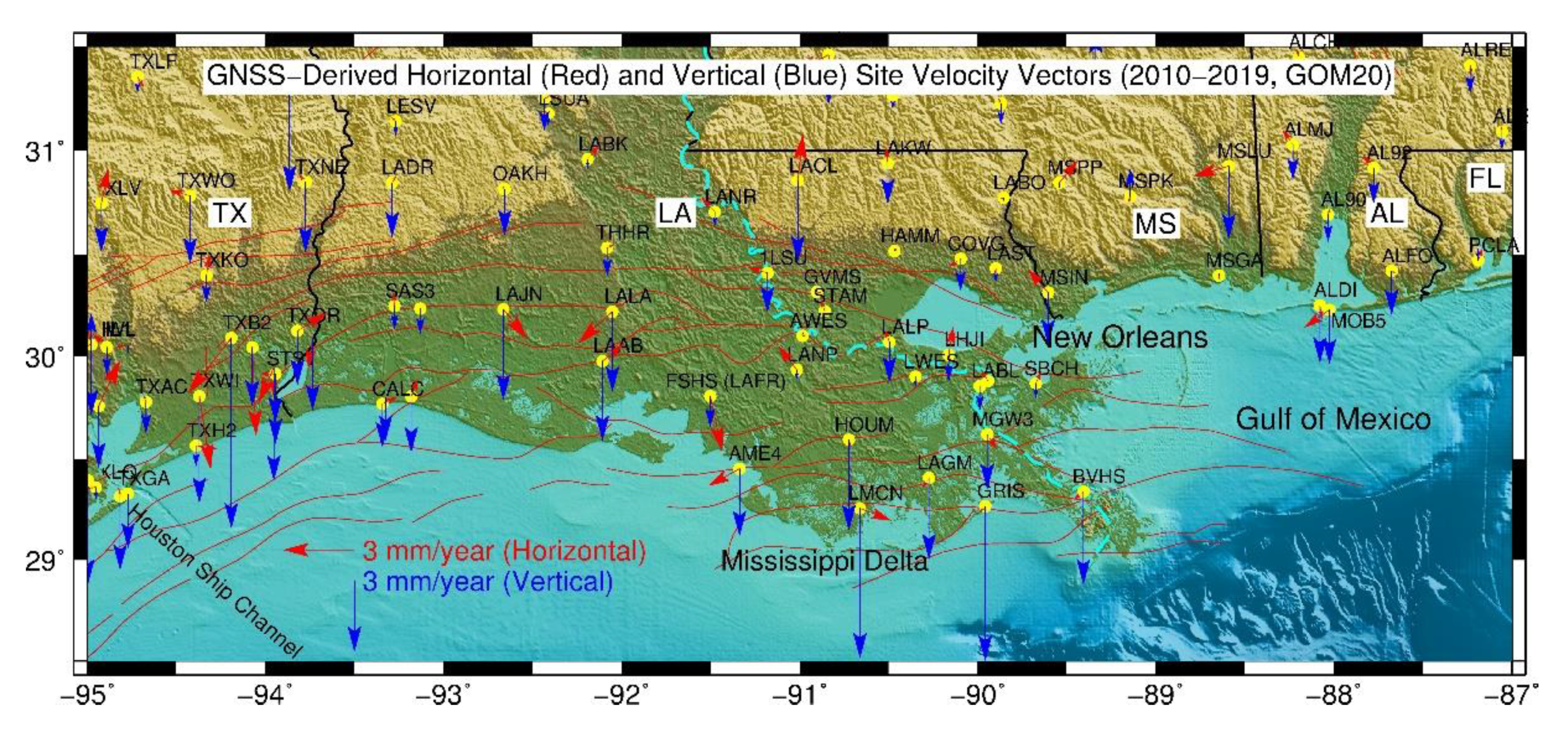
This post was edited on 6/9/24 at 8:55 am
Posted on 6/9/24 at 9:02 am to udtiger
quote:
Oilfield canals have nothing to do with subsidence. They have allowed for an acceleration of saltwater intrusion.
Agreed.
Extraction of underground resources has a great deal to do with it.
Y’all get Davis’ book. It has an excellent chapter on the creation of Port Sulphur and the Grand Ecaille’ Sulphur Mine. Also the dried shrimp, oyster and trapping industries.
The old mine has sunk just like Bully Camp , Lake Pelto, Caillou Island etc.
Sulphur and oil extraction cause major subsidence from what I see.
This post was edited on 6/9/24 at 9:14 am
Posted on 6/9/24 at 10:35 am to Bigfishchoupique
quote:
Extraction of underground resources has a great deal to do with it.
Back then when they drilled for oil in coastal Louisiana, most of that oil was trapped in shallow wells.
Those shallow wells close to the surface coupled with the soft sandy soils allowed some areas to accellerate subsidence and create lakes that were once land.
Another resouce around the coast are Salt domes, those Salt domes are what allowed those deep deposits of oil and sulfur to reach so close to surface. I wonder if communities like Leeville were built on unknown salt domes and as oil and gas was extracted, the salt caverons mixed with water and the land subsided quicker there because there was no longer oil and gas and a pocket of salt under the ground.
Also, as long as those salt domes stay in tact where ground water does not enter the caveron, land can stay high, but as water permiates into the dome it can slowly sink or if there is massive break like in Bayou Corne a sink hole can form.
The crazy thing about Bayou Corne, in the weeks before the sink hole formed, residents reported gas leaking from under the ground as pockets of natural gas made their way to the surface as the ground was slowly collapsing underground, and then one morning a hole just formed in the swamp hundreds of feet deep.
I remember the Assumption OEP director went in in a boat and dropped 500 foot line with a weight and it did not hit bottom.
I wish I would have studied more Geology in college.
Posted on 6/9/24 at 11:03 am to Saunson69
I bought a book about it at a recent estate sale. Can’t wait to read it.
Posted on 6/9/24 at 11:48 am to Saunson69
quote:
It used to be a resort in 1850s and a hurricane wiped it out?
How did people get there...
...there was a road that lead all the way down here in the 1800s.
I don't think cars existed then, but even if they did, it's wayyy out there past all continuous land that could service a road.
But really, just wanting to know what the island was like?
All great questions. And many more can be asked. What a spectacular area to investigate! Lotta missing info & pieces from Soup to Nuts with the entire story, as well as the story of NO, LA, and the Delta region. VERY mysterious.
So what was this island like? (Same of the bristling series and sprinkling of LA islands at the time surrounding the Delta / Bayou.)
Accessed by no cars or large vehicles at the time. Way out of the way. Ok, so boats and ferry?
Were some of the land and land-bridges and isles created artificially? Terraformed? (Also "disappearing" artificially in time?) LA is festooned with canals and evidence of past canals.
We see on the Book cover an exclusive resort "hotel" ONLY obviously for the extremely wealthy and connected. But what kind of civilization built out such a mind-blowing structure? Why so expansive?? How many clients could possibly fill its hotel rooms?? It's worthy of mention in the same breath as the Grand Palaces of Europe. Does it mesh with the population of the Bayou/New Orleans area at the time during the early 1850s?
How did they do it? WHO built it? Logistics? Infrastructure? Plans? Builders? None of this info or docs exists. Louisiana may have the most mysterious "History" in North America (along with San Francisco).
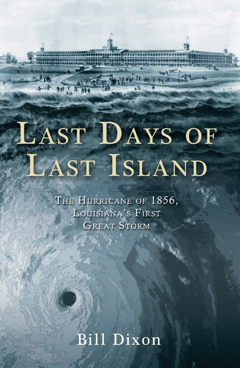
(ABOVE) Let's examine this "Hotel", or rather, Grand Palace of Yore, which is exactly what it was (of which can easily be speculated was the case far before the early 1850s when this hotel and resort was already well established). It resembles World Fair Expo buildings, doesn't it? Many similar grand structures exist along the US East coast -- from New England to NJ to South Carolina. They are also refererred to as "Hotels".
How much of this particular original Hotel-Grand Palace survived the 1856 hurricane? Anyone know?
IMO, this Hotel was built by a previous civilization as a Grand Palace for its "governor" or Elite(s) far before the 1800s. (can't prove it of course).
I also believe New Orleans was built by a previous civilization as an Imperial Capitol; circumstantial evidence of maps, aerial drawings of the river and already established built-out city back up the claim.
This post was edited on 6/9/24 at 11:50 am

Posted on 6/9/24 at 11:51 am to Saunson69
quote:
in the 1800s. I don't think cars existed then
No shite?

 Page 3 of 3


Popular
Back to top