- My Forums
- Tiger Rant
- LSU Recruiting
- SEC Rant
- Saints Talk
- Pelicans Talk
- More Sports Board
- Fantasy Sports
- Golf Board
- Soccer Board
- O-T Lounge
- Tech Board
- Home/Garden Board
- Outdoor Board
- Health/Fitness Board
- Movie/TV Board
- Book Board
- Music Board
- Political Talk
- Money Talk
- Fark Board
- Gaming Board
- Travel Board
- Food/Drink Board
- Ticket Exchange
- TD Help Board
Customize My Forums- View All Forums
- Show Left Links
- Topic Sort Options
- Trending Topics
- Recent Topics
- Active Topics
Started By
Message

 1
1


Posted on 8/18/17 at 3:51 pm to rds dc
NHC latest advisory doesn't show as much of a dramatic turn north as the last advisory

Posted on 8/18/17 at 7:30 pm to ForeverLSU02
18z HWRF has a pretty large system in the BOC

Posted on 8/18/17 at 10:22 pm to rds dc
Harvey continues to battle shear this evening and is tilted towards the SW with height with an erratic convective pattern. Probably not much in the way of strengthening until the shear lets up.

Posted on 8/18/17 at 11:25 pm to rds dc
GFS has shifted way north over the last 24 hrs with the 00z moving into S. Texas

Posted on 8/18/17 at 11:35 pm to rds dc
Looks like a north trend across all the 00z models so far. It will be interesting to see what the Euro and HWRF do later tonight.
Posted on 8/18/17 at 11:54 pm to rds dc
I just looked at the model forecaster and It looks like it shows the storm extremely disorganized until right at landfall. Almost like it gets its shite together in a 12 hour span.
This post was edited on 8/18/17 at 11:55 pm

Posted on 8/19/17 at 12:56 am to rds dc
Looks like a turning MF thats gonna make me break out the generator!! 
Posted on 8/19/17 at 1:44 am to Jimmy2shoes
Euro is north again this run no where north as the GFS but North nevertheless.
Posted on 8/19/17 at 7:48 am to lsuman25
I know recon just got in the storm but Harvey is a mess. Wouldn't be surprised that this is an open wave now but I can see the NHC keeping it a storm since it could strengthen in the Western Caribbean.
Posted on 8/19/17 at 7:55 am to lsuman25
Harvey looks really bad this morning and might have opened back up into a wave. That would tend to favor the faster more westerly solutions and would make it hard for it to get very far north, given the current setup.
Posted on 8/19/17 at 8:20 am to rds dc
The 00z Euro and 00z/06z GFS are both good for those areas in Texas that need rain. A lot of the moisture associated with Harvey's wave pouch ends up in Texas and it combines with a front to produce widespread rain.
This post was edited on 8/19/17 at 8:51 am
Posted on 8/19/17 at 8:48 am to lsuman25
quote:
I know recon just got in the storm but Harvey is a mess. Wouldn't be surprised that this is an open wave now but I can see the NHC keeping it a storm since it could strengthen in the Western Caribbean.
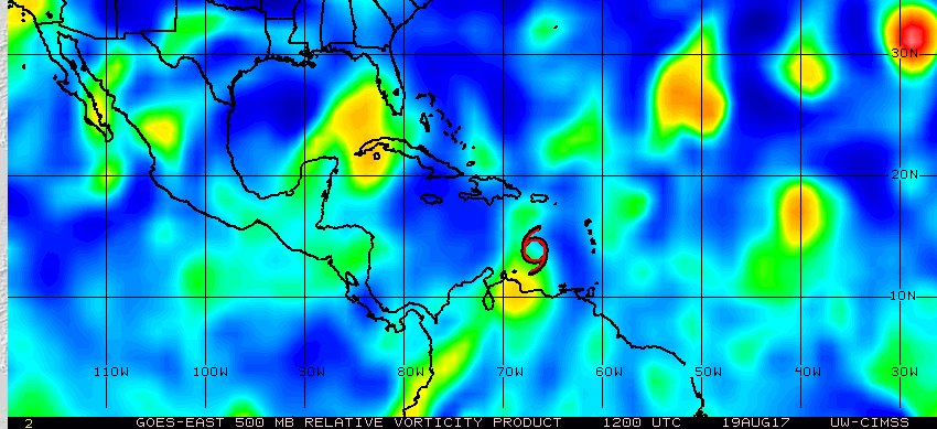
It will be interesting to see what they do, it appears the system has decoupled based on 12z 500mb analysis
ETA: recon probably found enough to justify keeping it as is.
This post was edited on 8/19/17 at 9:07 am
Posted on 8/19/17 at 9:51 am to rds dc
Still TS Harvey
Posted on 8/19/17 at 10:02 am to rds dc
What do you think that system out towards Florida is going to do? Weatherman I saw yesterday said something it's likely not going to have a huge impact on Gulf due to it likely getting demolished. At worst, probably a big rain maker.
This post was edited on 8/19/17 at 10:03 am
Posted on 8/19/17 at 10:04 am to lsuman25
quote:
Still TS Harvey
The discussion was like, "yea, it's not really a TS but maybe there are some TS force winds out there..."
Posted on 8/19/17 at 10:10 am to deuce985
quote:
What do you think that system out towards Florida is going to do? Weatherman I saw yesterday said something it's likely not going to have a huge impact on Gulf due to it likely getting demolished. At worst, probably a big rain maker.
The setup has never really been favorable for that system to develop. Look at this post for a bit more detail on why 92L had issues and why the models are struggling with the future track of Harvey LINK
Posted on 8/19/17 at 10:49 am to rds dc

 Page 5 of 618

Popular
Back to top