- My Forums
- Tiger Rant
- LSU Recruiting
- SEC Rant
- Saints Talk
- Pelicans Talk
- More Sports Board
- Coaching Changes
- Fantasy Sports
- Golf Board
- Soccer Board
- O-T Lounge
- Tech Board
- Home/Garden Board
- Outdoor Board
- Health/Fitness Board
- Movie/TV Board
- Book Board
- Music Board
- Political Talk
- Money Talk
- Fark Board
- Gaming Board
- Travel Board
- Food/Drink Board
- Ticket Exchange
- TD Help Board
Customize My Forums- View All Forums
- Show Left Links
- Topic Sort Options
- Trending Topics
- Recent Topics
- Active Topics
Started By
Message
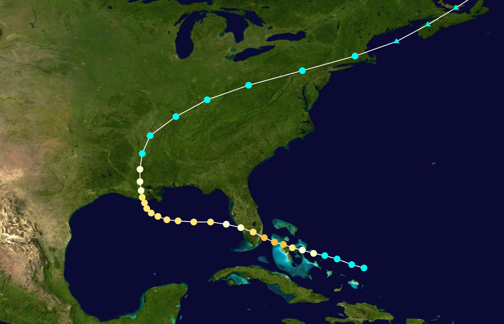
August 19, 1888 - Strong category 2 hurricane makes landfall near Cocodrie
Posted on 8/19/25 at 12:08 am
Posted on 8/19/25 at 12:08 am
 >
> quote:
This hurricane was considered the "severest and most extensive" to hit Louisiana since the Racer's Storm of 1837. It affected much of northern Gulf coast. In New Orleans, all electric light, telegraph, and phone wires went down that Sunday night. By Monday morning, the storm was at its height. Ninety mile an hour winds rampaged through the city. Almost the entire city was submerged.
The Teche also felt the storm. Sugar houses and sheds were blown down. Franklin had many homes with roofs blown off and leveled. Two churches in Morgan city were almost demolished. Local wharves were damaged and the rice crop suffered severely. Much wind damage was noted in Plaquemine, St. James, Donaldsonville, Houma, Convent, and Tigerville (named Gibson a couple weeks later after the senior Louisiana Senator at the time).
Rain totals for southern and central Louisiana were commonly 3-4 inches. Produced 7.9" of rain in New Orleans; 14.14" that week. Maurepas had 11.48" of rain during the same period. All this water led to extensive flooding in Mandeville. Rice, sugarcane, and cotton crops were a total loss in some areas of Southeast Louisiana. Grand Coteau lost much of it fruit crop.
Several churches were completely destroyed. Steamboats and sail boats alike were driven ashore by the wind and seas, including the steamers Keokuk, W.G. Little, and Laura, which were sunk. Trees were uprooted across the area
Several people perished in the storm. Damages totaled near $2.7 million with the worst occurring in Southeast Louisiana. Half the damage occurred to crops, with a third due to sunk coal in New Orleans harbor.
quote:
Re-intensifying over the Gulf of Mexico, the hurricane attained a secondary peak intensity of 110 miles per hour (177 km/h) before hitting Louisiana at that intensity. Areas along the Gulf Coast reported significant, widespread destruction from heavy rains, storm surge, and high tides, especially in Louisiana, where the storm destroyed crops and blew down buildings.
quote:
After entering the Gulf of Mexico off Southwest Florida, the cyclone began to re-intensify and turn to the west. By 18:00 UTC on August 17, the hurricane regained winds equivalent to those of a modern Category 2 hurricane on the Saffir-Simpson hurricane wind scale. After having traveled west-northwest for its entire lifespan, at this time its path shifted to the west and began to approach the northern U.S. Gulf Coast.
By 00:00 UTC on August 18, the cyclone attained its second peak intensity of 110 mph (177 km/h), just below the modern Category 3 on the Saffir-Simpson hurricane wind scale. As it neared the coast of Louisiana, the hurricane maintained its intensity while gradually turning to the northwest and north-northwest. Around 16:00 UTC on August 19, the center of the cyclone made landfall just south of Cocodrie in Terrebonne Parish with winds of 110 mph (177 km/h). As it moved inland over the marshes of southern Louisiana, the hurricane turned northward and slowly weakened. By 18:00 UTC on August 20, the cyclone weakened to a strong tropical storm as it neared the town of Greenville in western Mississippi.
quote:
The Florida Panhandle, closer to the center of the storm, experienced much higher winds and sustained heavier damages. Winds of 60 mph (97 km/h) affected the town of Pensacola, causing significant damage to property in the area.[6]
Farther west, other communities reported even more severe damage due to high tides and storm surge. For instance, the city of Mobile, Alabama, experienced one of its worst floods on record as a storm surge caused the Mobile River to overflow, submerging the Mobile waterfront to a depth of 3 ft (0.91 m) and spreading floodwater two to three blocks inland.[1][13] Strong winds that peaked at 55 mph (89 km/h) in the city topped trees, blew down fences, and unroofed some homes.[1][13]
Some damage occurred along the Mississippi coast as waves washed out some coastal structures and winds prostrated trees.[14] However, the worst damage occurred in the Mississippi River Delta, just to the east of the center, where severe flooding left large sections of countryside underwater.[7][14] Severe damage occurred to crops in the area, particularly rice and sugarcane: entire rice fields were flooded to a depth of several feet, and much of the sugarcane crop was flattened by strong winds. In the Bayou Teche country, the hurricane blew down numerous outbuildings, unroofed numerous homes, and destroyed some large dwellings and churches.[14] After the storm, growers estimated that 30–60% of the rice crop sustained damage.[15] In many areas at least one-third of the timber was downed.
HoumaToday story from 2018 reporting on the hurricane
 6
6


Posted on 8/19/25 at 2:50 am to NorthEndZone
I remember it like it was yesterday.
Posted on 8/19/25 at 6:00 am to NorthEndZone
Global warming.
Posted on 8/19/25 at 6:05 am to NorthEndZone
Cat 2! It just goes to show how much better construction techniques and practices are today.
Posted on 8/19/25 at 6:23 am to DustyDinkleman
quote:
I remember it like it was yesterday.
Now we know where “Dusty” comes from.

Posted on 8/19/25 at 6:28 am to NorthEndZone
Wasn't this the one that destroyed that huge hotel/resort to the SW of NO?
Posted on 8/19/25 at 6:49 am to udtiger
quote:
Wasn't this the one that destroyed that huge hotel/resort to the SW of NO?
That one I believe was 1856.
Last Island Hurricane 1856-Wiki

Posted on 8/19/25 at 6:58 am to NorthEndZone
quote:There are 15 fanbases in the SEC that wish this on College Station.
Grand Coteau lost much of it fruit crop.
Posted on 8/19/25 at 7:01 am to Tarps99
That's it. Thanks.
Posted on 8/19/25 at 7:08 am to NorthEndZone
How can they even plot the path on a map without it just being a complete guess? Landfall areas sure, but oceanic path from 1888 has to just be a guess right?
Posted on 8/19/25 at 8:51 am to BoogaBear
Yeah. All they had in the 1880s were barometers in the bigger cities like New Orleans and reports from ships that were able to survive the storm and report the conditions observed at sea.

 Page 1 of 1


Back to top