- My Forums
- Tiger Rant
- LSU Recruiting
- SEC Rant
- Saints Talk
- Pelicans Talk
- More Sports Board
- Fantasy Sports
- Golf Board
- Soccer Board
- O-T Lounge
- Tech Board
- Home/Garden Board
- Outdoor Board
- Health/Fitness Board
- Movie/TV Board
- Book Board
- Music Board
- Political Talk
- Money Talk
- Fark Board
- Gaming Board
- Travel Board
- Food/Drink Board
- Ticket Exchange
- TD Help Board
Customize My Forums- View All Forums
- Show Left Links
- Topic Sort Options
- Trending Topics
- Recent Topics
- Active Topics
Started By
Message
 3
3

Posted on 1/2/17 at 10:17 am to yourmusicisbad
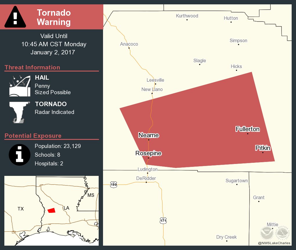
First Tor warning of the day
Posted on 1/2/17 at 10:17 am to yourmusicisbad
Watching those storms near Ville Platte
Posted on 1/2/17 at 10:19 am to yourmusicisbad
Mean storm cell motion 250 degrees at 40 KT (46 mph). MOVG ENE.
This post was edited on 1/2/17 at 10:20 am
Posted on 1/2/17 at 10:20 am to MottLaneKid

Posted on 1/2/17 at 10:20 am to MottLaneKid
Tor Watch coming shortly for BR and New Orleans.
Posted on 1/2/17 at 10:20 am to GEAUXmedic

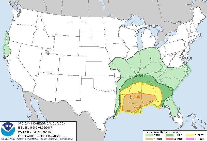
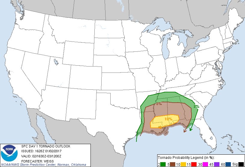
Mesoscale Discussion 0009
NWS Storm Prediction Center Norman OK
1017 AM CST Mon Jan 02 2017
Areas affected...southeast Louisiana through southern Mississippi
Concerning...Severe potential...Tornado Watch likely
Valid 021617Z - 021815Z
Probability of Watch Issuance...95 percent
SUMMARY...The threat for damaging wind and a few tornadoes is
expected to increase from southeast Louisiana through southern
Mississippi into southwest Alabama from late morning into the
afternoon. A tornado watch will likely be issued for this region by
17Z.
DISCUSSION...This morning a coastal warm front extends from the FL
Panhandle through the MS boot heel into southeast and west central
Louisiana where it intersects a pre-frontal squall line. Widespread
clouds have been a limiting factor so far for a more robust severe
threat. However, the moist boundary layer south of the warm front is
destabilizing, primarily due to theta-e advection, but some cloud
breaks will be possible this afternoon supporting MLCAPE from
1000-1500 j/kg. The squall line will likely continue east next
several hours as it intercepts the moistening boundary layer along
and south of the warm front. Additional more discrete storms will
likely continue developing within pre-frontal confluence bands
within the destabilizing warm sector. Some strengthening of broad
southwesterly low-level jet will occur into the afternoon in
association with forcing for ascent accompanying the progressive
southern-stream shortwave trough. This will maintain sufficiently
large 0-2 km hodographs for a threat of low-level mesocyclones and a
few tornadoes, especially as discrete storms become surface-based
ahead of the line. Brief QLCS tornadoes in addition to damaging wind
will remain the primary threats within the squall line.
Posted on 1/2/17 at 10:27 am to GEAUXmedic
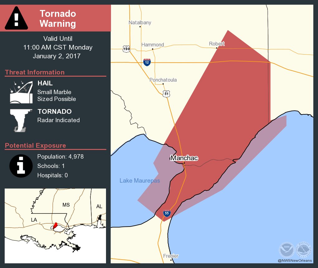
Check out the hook over lake maurepas
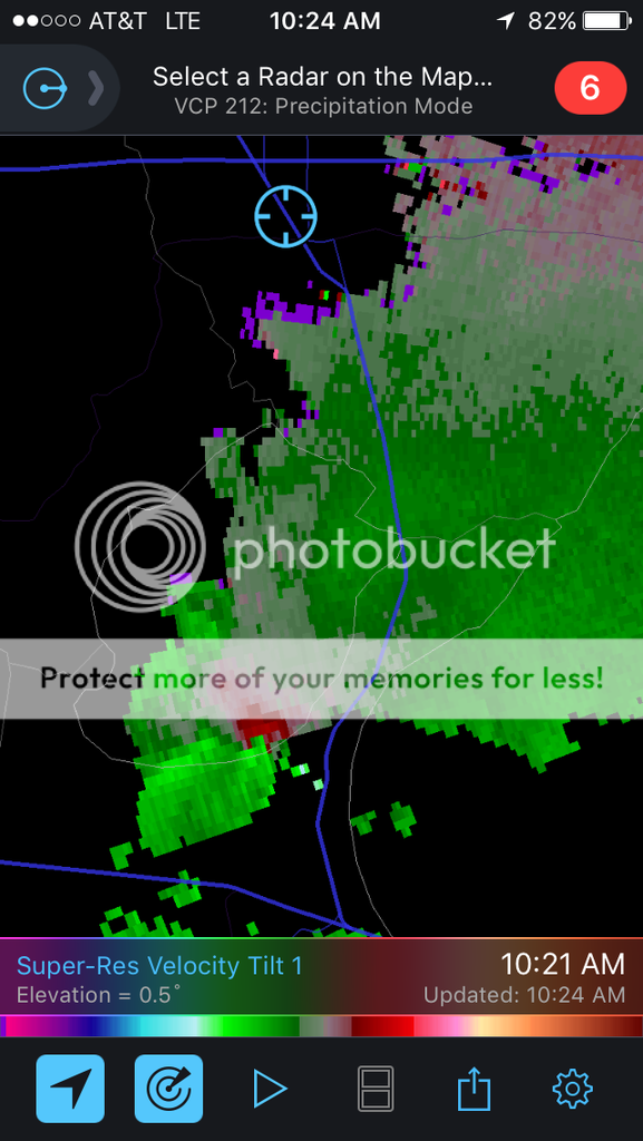
This post was edited on 1/2/17 at 10:28 am
Posted on 1/2/17 at 10:29 am to CypressTrout10
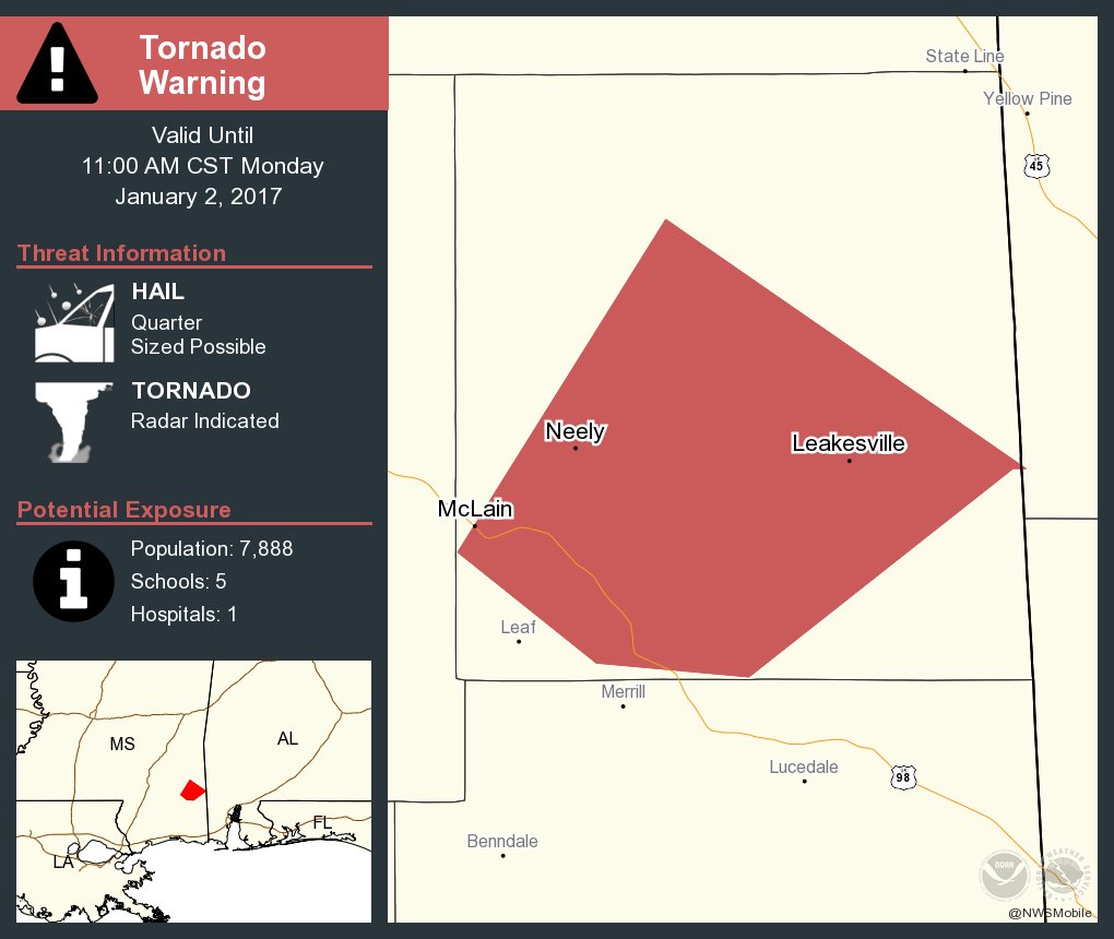
New Tor warning in Mississippi
Posted on 1/2/17 at 10:30 am to CypressTrout10
quote:
Check out the hook over lake maurepas
That is a legit hook with what appears to be a hail spike. Could be producing.

Posted on 1/2/17 at 10:30 am to CypressTrout10
What weather app do you have for your phone?
Posted on 1/2/17 at 10:32 am to biggsc
Already had to deal with flash flooding in Tuscaloosa

Storms seem to be following the interstate
Storms seem to be following the interstate
Posted on 1/2/17 at 10:33 am to rds dc
What weather app are you using?
Posted on 1/2/17 at 10:33 am to biggsc
Any storm chasers?
Posted on 1/2/17 at 10:33 am to MottLaneKid
Tornado warning: radar indicated tornado likely 9 miles north of laPlace, La moving NE at 30 mph.
10:30 am jan 2
10:30 am jan 2
Posted on 1/2/17 at 10:37 am to rds dc
I know your gonna be busy for a while but if you got a second what do you think of those cells out in Western Louisiana forming ahead of the squall line?
Posted on 1/2/17 at 10:38 am to MottLaneKid

Posted on 1/2/17 at 10:38 am to rds dc
At least the probabilities aren't high. Good luck to y'all

 Page 3 of 8

Popular
Back to top