- My Forums
- Tiger Rant
- LSU Recruiting
- SEC Rant
- Saints Talk
- Pelicans Talk
- More Sports Board
- Fantasy Sports
- Golf Board
- Soccer Board
- O-T Lounge
- Tech Board
- Home/Garden Board
- Outdoor Board
- Health/Fitness Board
- Movie/TV Board
- Book Board
- Music Board
- Political Talk
- Money Talk
- Fark Board
- Gaming Board
- Travel Board
- Food/Drink Board
- Ticket Exchange
- TD Help Board
Customize My Forums- View All Forums
- Show Left Links
- Topic Sort Options
- Trending Topics
- Recent Topics
- Active Topics
Started By
Message
re: Severe Weather Rolls On: May 7-10, 2024
Posted on 5/8/24 at 9:15 pm to LegendInMyMind

Posted on 5/8/24 at 9:15 pm to LegendInMyMind
quote:
I posted her here a while ago when she first came to town. Yessir!

 0
0

Posted on 5/8/24 at 9:16 pm to Roll Tide Ravens
I gotcha. Keep that wickness above St Clair County. I got a feeling tomorrow might get dicey though.
Posted on 5/8/24 at 9:16 pm to Tower_Tiger12
quote:
We have rules here..


Posted on 5/8/24 at 9:17 pm to Pedro
quote:
One of them was heavily involved with this huge research project, Vortex-SE, centered in Huntsville and it seemed like every time they deployed they ended up in sand mountain.
They're still doing good work. Vortex is out of UAH, a top notch met school. Also, currently under a tornado warning.
Posted on 5/8/24 at 9:19 pm to LegendInMyMind
Ahh I haven’t seen the ULM atmos department mention anything about it in a while so I wasn’t sure if it was still ongoing or not. I also don’t see very much of anything from them at all so that’s probably part of it.
Posted on 5/8/24 at 9:19 pm to Roll Tide Ravens
If you want to know how many lurkers follow these threads, just mention a female TV met. 
Posted on 5/8/24 at 9:20 pm to Pedro
quote:
Ahh I haven’t seen the ULM atmos department mention anything about it in a while so I wasn’t sure if it was still ongoing or not. I also don’t see very much of anything from them at all so that’s probably part of it.
It may even be under a different project now, but it is the same group.
Posted on 5/8/24 at 9:20 pm to LegendInMyMind
Research Park / Sparkman drive / University drive
Did some work with our contractors in that area years ago.
Did some work with our contractors in that area years ago.
Posted on 5/8/24 at 9:20 pm to LegendInMyMind
quote:
If you want to know how many lurkers follow these threads, just mention a female TV met.
If you lurkers are listening, I’ve called dibs.

Posted on 5/8/24 at 9:21 pm to NorthEndZone

Posted on 5/8/24 at 9:21 pm to LegendInMyMind
Brad Travis is in the path.
Posted on 5/8/24 at 9:21 pm to NorthEndZone
This storm crossing the Tennessee River earlier tonight:
Loading Twitter/X Embed...
If tweet fails to load, click here.This post was edited on 5/8/24 at 9:22 pm
Posted on 5/8/24 at 9:22 pm to Roll Tide Ravens
NWS Huntsville is still calling this a confirmed tornado coming into Huntsville.
Posted on 5/8/24 at 9:23 pm to footswitch
quote:
footswitch
Are you good? I'm guessing south of you?
This post was edited on 5/8/24 at 9:24 pm
Posted on 5/8/24 at 9:23 pm to Bobby OG Johnson
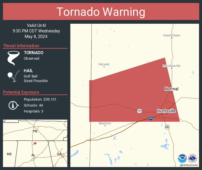
Severe Weather Statement
National Weather Service Huntsville AL
919 PM CDT Wed May 8 2024
ALC089-090230-
/O.CON.KHUN.TO.W.0021.000000T0000Z-240509T0230Z/
Madison AL-
919 PM CDT Wed May 8 2024
...A TORNADO WARNING REMAINS IN EFFECT UNTIL 930 PM CDT FOR
NORTHWESTERN MADISON COUNTY...
At 919 PM CDT, a confirmed tornado was located over northwestern
Huntsville, moving east at 30 mph.
HAZARD...Damaging tornado and golf ball size hail.
SOURCE...Radar confirmed tornado.
IMPACT...Flying debris will be dangerous to those caught without
shelter. Mobile homes will be damaged or destroyed. Damage
to roofs, windows, and vehicles will occur. Tree damage is
likely.
This tornado will be near...
Northern Huntsville, Meridianville, and Alabama A And M University
around 925 PM CDT.
Posted on 5/8/24 at 9:24 pm to LegendInMyMind
quote:
Our Sand Mountain poster needs to watch out.
Yes, I was the stupid person standing on my porch looking at the storm. It was slightly north of me but still to close for comfort. I was videoing towards the circulation according to RadarScope but don’t think I got anything during the lightning flashes.
Posted on 5/8/24 at 9:24 pm to NorthEndZone
This ball look the radar shows moving into Huntsville looks very much not good
Posted on 5/8/24 at 9:25 pm to NorthEndZone
Over UAH area
Posted on 5/8/24 at 9:25 pm to LegendInMyMind
So far just nervous. Watching Brad and reading y’all.
I appreciate it folks.
I’m in Meridianville tonight and we seem to be between. Again thanks.
I appreciate it folks.
I’m in Meridianville tonight and we seem to be between. Again thanks.
Posted on 5/8/24 at 9:25 pm to Wishnitwas1998
quote:
This ball look the radar shows moving into Huntsville looks very much not good
I don't think that part of the storm is the issue right now. Things have been weird, though, so......I dunno.

 Page 19 of 36

Popular
Back to top