- My Forums
- Tiger Rant
- LSU Recruiting
- SEC Rant
- Saints Talk
- Pelicans Talk
- More Sports Board
- Coaching Changes
- Fantasy Sports
- Golf Board
- Soccer Board
- O-T Lounge
- Tech Board
- Home/Garden Board
- Outdoor Board
- Health/Fitness Board
- Movie/TV Board
- Book Board
- Music Board
- Political Talk
- Money Talk
- Fark Board
- Gaming Board
- Travel Board
- Food/Drink Board
- Ticket Exchange
- TD Help Board
Customize My Forums- View All Forums
- Show Left Links
- Topic Sort Options
- Trending Topics
- Recent Topics
- Active Topics
Started By
Message

Tornado outbreak, 94 dead, Upwards of 100 unaccounted for search/rescue & cleanup ongoing
Posted on 12/8/21 at 1:52 pm
Posted on 12/8/21 at 1:52 pm
SPC Day 3 Outlook:
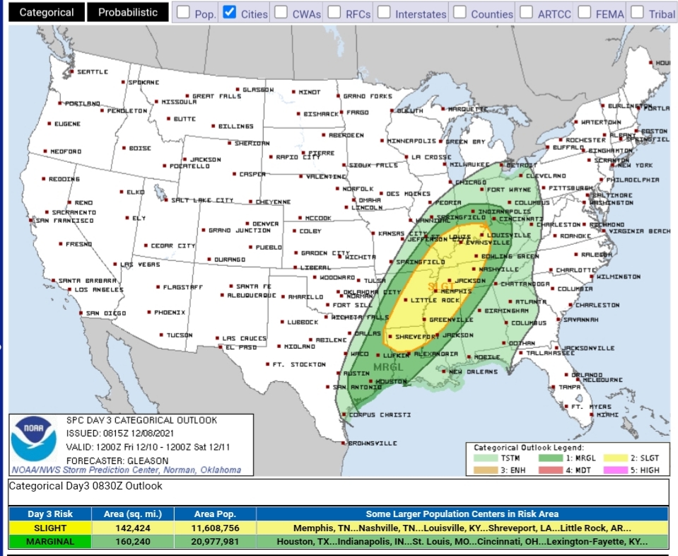
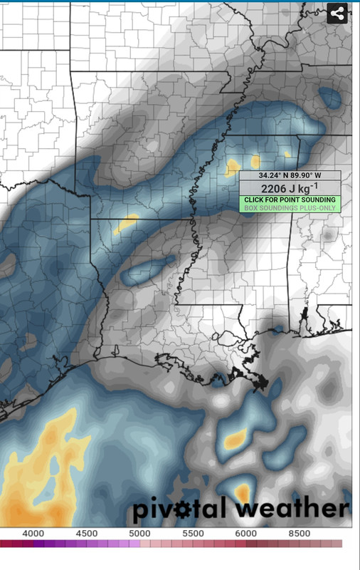
We will likely see an upgrade to an Enhanced risk in future updates for the same general area. With temps/dewpoints in the low to mid 70s and mid 60s, this feels more like March than December. There will be plenty of shear across most of the risk area with stronger instability over Northern Louisiana and into Arkansas.
This will be a predominantly overnight event with some potential for afternoon/early evening storms if a cell or two can break through the cap during that period. Don't be surprised if you go to bed without storms only to wake up to a Tornado Warning.
Farther East, the threat becomes more linear early in the AM, but we will probably see plenty of embedded rotation within the line.
On the backside of the trough/front Duke should see at least some snow.
I don't know how to embed the SPC link/image where it automatically changes with each update. So, if someone can help with that, I'd appreciate it.
quote:
Day 3 Convective Outlook NWS Storm Prediction Center Norman OK 0215 AM CST Wed Dec 08 2021
Valid 101200Z - 111200Z ...THERE IS A SLIGHT RISK OF SEVERE THUNDERSTORMS ACROSS PARTS OF THE LOWER/MID MISSISSIPPI VALLEY INTO THE LOWER OHIO VALLEY...
...SUMMARY... Severe thunderstorms capable of producing a few tornadoes and scattered damaging winds appear possible Friday into Friday night across parts of the lower/mid Mississippi Valley, Ohio/Tennessee Valleys, and Southeast.
...Synopsis... A highly amplified upper trough centered over the Rockies Friday morning should advance eastward across the Plains through the day, eventually reaching the MS Valley by the end of the period. Rather strong low/mid-level southwesterly flow will be present ahead of the upper trough across much of the lower/mid MS Valley into the OH/TN Valleys.
A surface low initially over the central High Plains is forecast to develop eastward across the southern/central Plains through the day. This low should continue northeastward while gradually deepening over the mid MS Valley, Midwest, and Great Lakes from Friday evening though early Saturday morning.
Rich low-level moisture characterized by at least mid to upper 60s surface dewpoints will likely be in place Friday morning from central/east TX into the lower MS Valley and Mid-South. As both the large-scale upper trough and related surface low shift eastward, this moist low-level airmass is forecast to spread northward in tandem with a warm front into the mid MS Valley, OH/TN Valleys, and parts of the Southeast by Friday evening. A cold front attendant to the surface low will sweep eastward from the southern/central Plains to the vicinity of the TX Coast and MS River by the end of the period.
...Lower/Mid Mississippi Valley into the Ohio/Tennessee Valleys and Southeast... Even with the low-level moisture across these regions increasing through the day, generally modest mid-level lapse rates will tend to limit the degree of instability that can develop, especially with northward extent into the mid MS Valley, Midwest, and OH Valley. Still, most guidance suggests that MLCAPE will be sufficient (at least 500 J/kg) across a majority of the warm sector to support surface-based storms. A fair amount of uncertainty remains regarding the timing of robust convection. The 00Z ECMWF indicates that an embedded shortwave trough will overspread the lower MS Valley during the day, potentially supporting convective initiation earlier than other guidance would suggest. Regardless, thunderstorms will likely increase in coverage and intensity along/ahead of the cold front by Friday evening and continue eastward through Friday night, as strong forcing associated with the large-scale upper trough overspreads the warm sector.
Deep-layer shear is forecast to become quite strong by Friday evening owing to the strength of the mid-level southwesterly flow. 50+ kt of effective bulk shear will easily support updraft organization. A mix of supercells and clusters may develop initially, but dominant convective mode should quickly trend to linear Friday night as thunderstorms grow upscale into one or more lines along/ahead of the cold front. Even though not much veering with height is forecast in the boundary layer due to mostly southwesterly flow, there should be ample speed shear, as the winds at 850 mb are expected to strengthen to 50-60+ kt Friday night. Strong 0-1-km SRH should support low-level rotation with any supercells or embedded QLCS circulations, and a few tornadoes may occur. Isolated to scattered severe/damaging winds also appear possible given the strength of the low-level flow, as it will not take much for convective downdraft accelerations to allow the already enhanced low-level winds to reach the surface.
Primary uncertainties precluding greater severe probabilities at this time include the degree of boundary-layer instability, a large component of front-parallel flow in both low/mid levels, and the late timing of robust convective development. The northern extent of any severe threat in the Midwest/OH Valley is also quite uncertain, but most guidance suggests at least upper 50s to perhaps low 60s surface dewpoints may advance as far northward as east-central IL into IN and southwestern OH. This may be sufficient for low-topped convection to become surface based. The eastern extent of the severe threat will be tied to the location of storms along or just ahead of the front at the end of the Day 3 period, with expectations that at least a marginal/isolated severe threat will likely continue farther east into Day 4/Saturday. ..Gleason.. 12/08/2021
We will likely see an upgrade to an Enhanced risk in future updates for the same general area. With temps/dewpoints in the low to mid 70s and mid 60s, this feels more like March than December. There will be plenty of shear across most of the risk area with stronger instability over Northern Louisiana and into Arkansas.
This will be a predominantly overnight event with some potential for afternoon/early evening storms if a cell or two can break through the cap during that period. Don't be surprised if you go to bed without storms only to wake up to a Tornado Warning.
Farther East, the threat becomes more linear early in the AM, but we will probably see plenty of embedded rotation within the line.
On the backside of the trough/front Duke should see at least some snow.
I don't know how to embed the SPC link/image where it automatically changes with each update. So, if someone can help with that, I'd appreciate it.
This post was edited on 12/12/21 at 7:10 pm
 29
29


Posted on 12/8/21 at 1:57 pm to LegendInMyMind
75 degrees Friday
Posted on 12/8/21 at 2:25 pm to LegendInMyMind
QLCS tors and straight line winds seem the risk here. There's a whole lot of forcing here, it should line out quick.
Oh on my end, thinking 2-5" of snow. Going to catch a cold front passage while under the right entrance of the jet stream. Not looking forward to the -4 with a 15 mph wind Saturday morning though.
Oh on my end, thinking 2-5" of snow. Going to catch a cold front passage while under the right entrance of the jet stream. Not looking forward to the -4 with a 15 mph wind Saturday morning though.

Posted on 12/8/21 at 2:33 pm to Duke
Are chances of cold Christmas officially 0%?
Posted on 12/8/21 at 2:45 pm to When in Rome
A cold front into the south around Christmas isnt that unreasonable. Im looking for another good storm out my way sometime before Christmas and that would cut across the country in the following days with a trailing cold front.
When exactly? IDK.
The where matters too, could be too far north to bring down much to Louisiana. Still IDK.
How does... lets say 15% with upside hit you?
When exactly? IDK.
The where matters too, could be too far north to bring down much to Louisiana. Still IDK.
How does... lets say 15% with upside hit you?
Posted on 12/8/21 at 2:55 pm to Duke
quote:
A cold front into the south around Christmas isnt that unreasonable

quote:
How does... lets say 15% with upside hit you?

Posted on 12/8/21 at 2:57 pm to Duke
quote:
could be too far north to bring down much to Louisiana

Posted on 12/8/21 at 3:00 pm to When in Rome
That's my favorite gif 
Posted on 12/8/21 at 3:01 pm to GEAUXT
itsgonrain.gif.exe
Posted on 12/8/21 at 3:01 pm to GEAUXT
It’s definitely in my top 5
Posted on 12/8/21 at 3:25 pm to LegendInMyMind
High of 80 here today
Yippee for southern weather. Most places get a white Christmas full of cheer. We get 70-80 degrees and a fricked up roof
Yippee for southern weather. Most places get a white Christmas full of cheer. We get 70-80 degrees and a fricked up roof
Posted on 12/8/21 at 4:32 pm to Duke
quote:
QLCS tors and straight line winds seem the risk here. There's a whole lot of forcing here, it should line out quick.
I think there is going to be a fair chance for a period that will see some cells go up before the line forms. Short range models are starting to pick it up some now and it delays the QLCS some, too. We'll see.
Posted on 12/8/21 at 4:33 pm to LegendInMyMind
quote:
I think there is going to be a fair chance for a period that will see some cells go up before the line forms. Short range models are starting to pick it up some now and it delays the QLCS some, too. We'll see.
it'll find a seam in the "south of Ellick mini-tornado alley" to spin up something well ahead of the line

Posted on 12/8/21 at 4:36 pm to LegendInMyMind
We had flurries this morning and sleet. Then it's going to be 70s on Friday.
While I don't mind it being warmer, the swings are killing me.
While I don't mind it being warmer, the swings are killing me.
This post was edited on 12/8/21 at 4:36 pm
Posted on 12/8/21 at 4:37 pm to LegendInMyMind
December severe weather outbreaks tend to have a lot of energy due to a colder pool of air associated with cold fronts this time of year.
Posted on 12/8/21 at 5:09 pm to LegendInMyMind
I just pulled a "PDS Tornado" sounding for NW Miss Delta region on the NAM model for 9pm Friday night
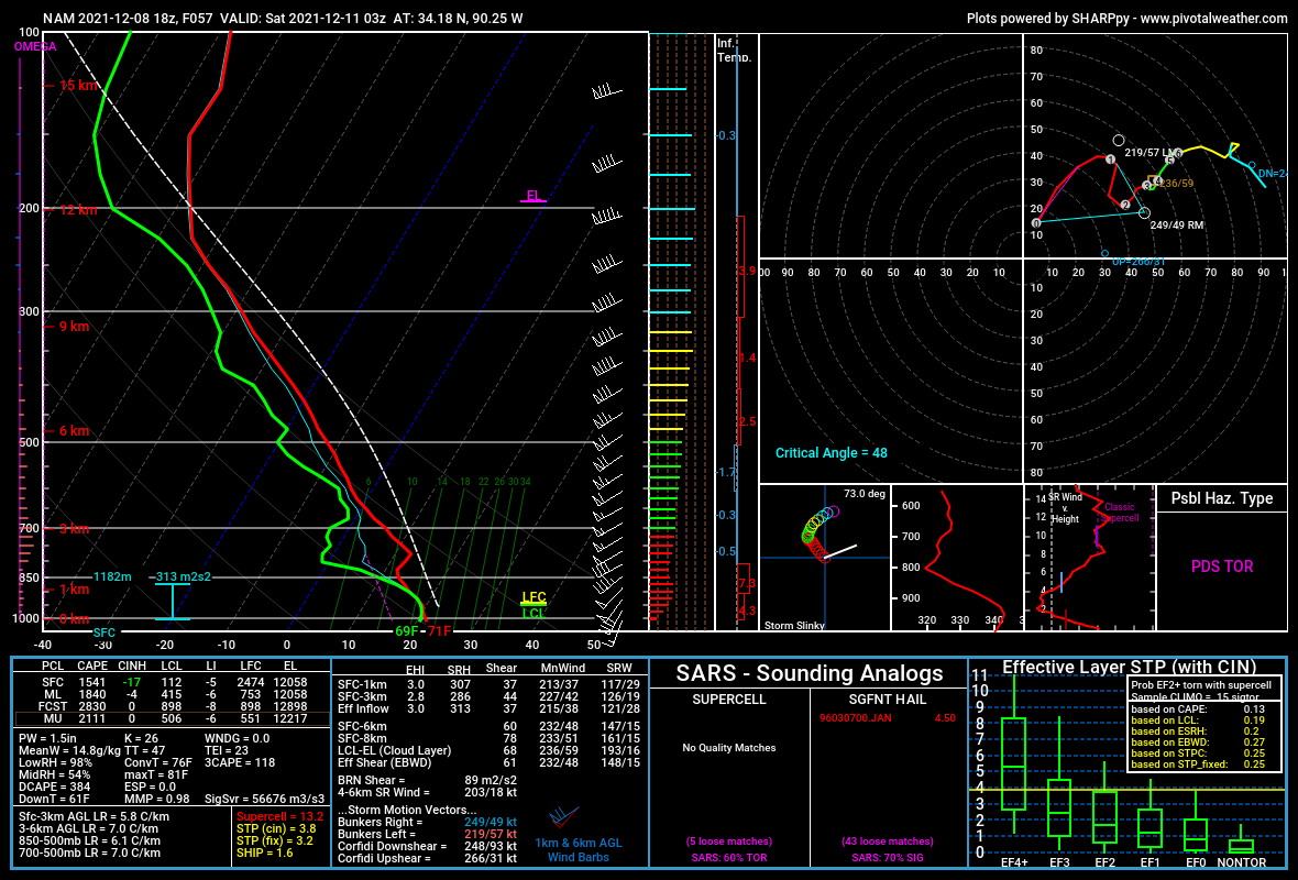
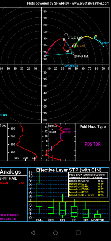
Posted on 12/8/21 at 5:18 pm to lockthevaught
Yeah, I've picked a couple every time I've checked the models for several days now.

Posted on 12/8/21 at 5:19 pm to LegendInMyMind
Thanks Biden
Posted on 12/8/21 at 7:52 pm to LegendInMyMind
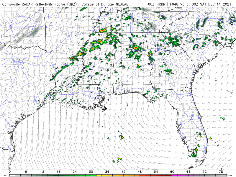
00z HRRR is also picking up on pop-up cells prior to the QLCS forming. This isn't a good look. Still too far out for the HRRR to show the development of the main line.

 Page 1 of 90

Popular
Back to top