- My Forums
- Tiger Rant
- LSU Recruiting
- SEC Rant
- Saints Talk
- Pelicans Talk
- More Sports Board
- Coaching Changes
- Fantasy Sports
- Golf Board
- Soccer Board
- O-T Lounge
- Tech Board
- Home/Garden Board
- Outdoor Board
- Health/Fitness Board
- Movie/TV Board
- Book Board
- Music Board
- Political Talk
- Money Talk
- Fark Board
- Gaming Board
- Travel Board
- Food/Drink Board
- Ticket Exchange
- TD Help Board
Customize My Forums- View All Forums
- Show Left Links
- Topic Sort Options
- Trending Topics
- Recent Topics
- Active Topics
Started By
Message
re: Plotting stands on a map/app
Posted on 9/18/18 at 1:11 pm to The Donald
Posted on 9/18/18 at 1:11 pm to The Donald
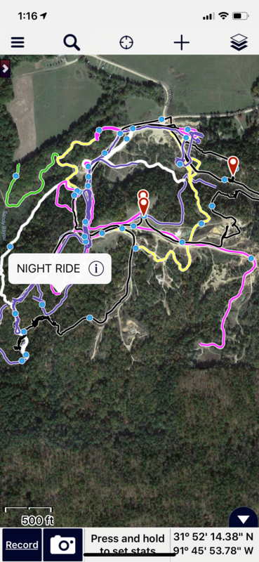
Gaia GPS is by far the greatest GPS App I've ever used.
you can record tracks, snap pictures that are geolocated, use "guide me", etc.
The PC interface is pretty sweet too for going back and adding details, editing way points or downloading more maps. i use it for fishing, hunting, hiking and wheeling.
it's also easy to share with other users (friends)
I've recorded every track i've made off the pavement for the last 5 years.
Mobile interface:
PC interface:
This post was edited on 9/18/18 at 1:20 pm
 0
0


Posted on 9/18/18 at 2:02 pm to The Donald
Yeah I use and eTrex. I had to plug it into my laptop. It was a free program to download on my computer, don't have an app.
Posted on 9/18/18 at 9:32 pm to Motorboat
quote:
third. The free version is awesome and you get 10 free plat ownership queries/month
Fourth, tried onX, prefer huntstand.
Posted on 9/19/18 at 9:01 am to geauxskeet
I've used OnX, HuntStand and they are both good. I use Google Earth Pro a lot, and it will interface with Gaia I also use an app called Maps Plus that I really like.
Posted on 9/19/18 at 9:36 am to The Donald
Huntstand for me.

 Page 2 of 2


Popular
Back to top