




- My Forums
- Tiger Rant
- LSU Recruiting
- SEC Rant
- Saints Talk
- Pelicans Talk
- More Sports Board
- Fantasy Sports
- Golf Board
- Soccer Board
- O-T Lounge
- Tech Board
- Home/Garden Board
- Outdoor Board
- Health/Fitness Board
- Movie/TV Board
- Book Board
- Music Board
- Political Talk
- Money Talk
- Fark Board
- Gaming Board
- Travel Board
- Food/Drink Board
- Ticket Exchange
- TD Help Board
Customize My Forums- View All Forums
- Show Left Links
- Topic Sort Options
- Trending Topics
- Recent Topics
- Active Topics
Started By
Message
Inside route from Venice to Grand Isle
Posted on 7/16/26 at 10:32 am
Posted on 7/16/26 at 10:32 am
Taking my 24 ft Tideline to the tarpon rodeo next week and hoping to avoid trailering from Venice to GI. I am very familiar with Venice but have not spent much time on the west side of the river north of Red Pass. Thinking it might make sense to run up the river to Empire and then across behind the islands if its rough that day. Is there an inside route from Empire to Grand Isle that's easy to run?
I have a Florida marine tracks east Louisiana chip in my plotter. I emailed them and they said there was one marked on the chip but figured somebody here might have better info.
I have a Florida marine tracks east Louisiana chip in my plotter. I emailed them and they said there was one marked on the chip but figured somebody here might have better info.
 4
4


Posted on 7/16/26 at 11:51 am to swampmusic
Do you have a LA 1 standard mapping card?
They have some "proven" routes on there. Use with caution tho. Some of them say that they are proven but could have changed over the years.
They have some "proven" routes on there. Use with caution tho. Some of them say that they are proven but could have changed over the years.
This post was edited on 7/16/26 at 11:52 am
Posted on 7/16/26 at 12:08 pm to swampmusic
I don’t have a marked route, but it’s not a bad run from empire to GI
Posted on 7/16/26 at 12:15 pm to SOLA
Pretty easy run.
Posted on 7/16/26 at 12:17 pm to swampmusic
It's super easy. Go out of Red pass or head due W to SW to get to GI. Or you can run the bays to Empire and hit the beach by Bastian bay and run W to GI. That route is more protected water to get to GI.
Posted on 7/16/26 at 1:01 pm to swampmusic
quote:
Go out of Red pass or head due W to SW to get to GI.
If weather allows, that is the easiest. If it is rough, you have several options some more riskier than others.
Out of Red Pass, you can go west passed Sandy Point then cut into Scofiled Bay through Bay Coquette. Have to watch it though on south and west side of coquette since there are sandbars in there from old islands. Once across Scofield, take the boat lane north and you can cut across Adams Bay and Lake Washington which puts you on the north end of Barataria.
Alternatively, you can continue across the gulf in front of Scofield, cut between Scofield and Shell island, then take the boat lane up towards Empire to cut across Adams.
Saturday of this past weekend, we fished Scofield Bay from GI marina. At first light we had 2 ft seas so we just ran the gulf to the Empire Jetty then north to Scofield. Had 2-3 ft seas on way back so we ran gulf and then went in behind the islands at Four Bayous (Quatre Bayou).
Use Google Earth Pro, if you don't already, to go back to old aerials and you can see more of what looks safe. I have used it to create waypoints when needed to avoid old stuff when making a new route.
Posted on 7/17/26 at 10:40 am to LSUengr
My Garmin echomap ultra has a "Navigate to" feature. You set the parameters for your vessel (overhead clearance, minimum draft) and it will give you a path to follow to your chosen destination, like Google maps in a car. It's not something I have used because I don't need it in local waters, but I wondered how reliable it is for new places. Do any of y'all use that function and trust it?

Posted on 7/17/26 at 10:56 am to TwoFace
My bosses boat has it, but I have never used it. I have a Humminbird Helix 12, which has no option like that.
Posted on 7/17/26 at 12:39 pm to LSUengr
Thanks for the advice
Plenty of water in Adams Bay and Lake Washington?
The Tideline only drafts 14" but I know that entire area used to be land not too long ago
Plenty of water in Adams Bay and Lake Washington?
The Tideline only drafts 14" but I know that entire area used to be land not too long ago
Posted on 7/17/26 at 2:06 pm to swampmusic
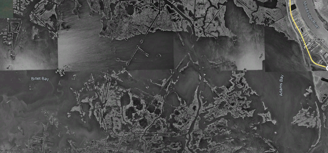
Adams Bay and Lake Washington have always been large bays void of land. There were some old strips of land between them. The image below is from 1989. There are still some shallow areas in there. I've only been across there once, so you still have to proceed with caution. Again, the safest route is Red Pass thru the Gulf to GI.
Posted on 7/17/26 at 4:37 pm to LSUengr
As others have said, it’s a pretty easy route.
Man we used to have some hella good times at the Tarpon!
Man we used to have some hella good times at the Tarpon!

Posted on 7/19/26 at 4:18 pm to GITiger66
Went in high school once. Launched in lafitte and had a spot to park boat at sand dollar. Thats it. 4 of us found places to sleep and rode in truck beds across island

Posted on 7/19/26 at 4:20 pm to freshtigerbait
The marsh changes almost monthly these days.....I would be cautious to trust routes that long...
One minor storm makes a big difference.
One minor storm makes a big difference.
This post was edited on 7/19/26 at 4:25 pm
Posted on 7/19/26 at 7:14 pm to TwoFace
I use the Garmin Navionics app on my phone to navigate pretty often. I don’t own my own boat but a member of Freedom boat club, so it’s my best option. Covered a lot of water from Naples to TB and it’s always pretty accurate. Especially if you add in boat parameters. We’ve gotten through some pretty skinny cuts you wouldn’t know existed or saved from being hung up on a bar with Navionics.

 Page 1 of 1


Popular
Back to top
 Follow TigerDroppings for LSU Football News