- My Forums
- Tiger Rant
- LSU Recruiting
- SEC Rant
- Saints Talk
- Pelicans Talk
- More Sports Board
- Fantasy Sports
- Golf Board
- Soccer Board
- O-T Lounge
- Tech Board
- Home/Garden Board
- Outdoor Board
- Health/Fitness Board
- Movie/TV Board
- Book Board
- Music Board
- Political Talk
- Money Talk
- Fark Board
- Gaming Board
- Travel Board
- Food/Drink Board
- Ticket Exchange
- TD Help Board
Customize My Forums- View All Forums
- Show Left Links
- Topic Sort Options
- Trending Topics
- Recent Topics
- Active Topics
Started By
Message

Where is/was Fort Bute (Bayou Manchac)?
Posted on 5/15/23 at 6:04 pm

Posted on 5/15/23 at 6:04 pm
I'm reading on the fascinating history of Akankia/Iberville River/Bayou Manchac including "The Forgotten History and Present-Day Peril of Bayou Manchac". I'm not from this area so I'm surprised to see that one of the proposed locations for New Orleans was Bayou Manchac @ Mississippi River to provide multiple ways of accessing the Gulf. I'm further surprised to see this waterway proposed for a major shipping channel through the 1820's when it was officially cut off.
One thing I don't see much info on, is the current day location or ruins of Fort Bute first built 1766. The accounts read that it was a decently sized earthen and timber fort that could house a couple hundred men. It also had at least one stone house so I'd imagine it might still be around. According to the map link below, It looks like it might be between UClub and the River, south of Ebenezer Church, north of Bayou Manchac.
What do you local Baton Rouge historians have on Fort Bute?
Old Map Showing Fort Bute LINK
 8
8


Posted on 5/15/23 at 6:16 pm to AutoYes_Clown
Interesting. I knew bayou Manchac used to be an important channel bringing ships to BR and always thought that was crazy.

Posted on 5/15/23 at 6:45 pm to AutoYes_Clown
Pretty sure it whatever was left was destroyed when the levee was built.
Posted on 5/15/23 at 6:50 pm to AutoYes_Clown
Under the old Willow Glen power station. Nearabout.
Reference from a history book I read about Manchac/Fort/Isle of New Orleans I read 30 years ago.
Granted, could have been the only point of reference available at the time of the book.
Reference from a history book I read about Manchac/Fort/Isle of New Orleans I read 30 years ago.
Granted, could have been the only point of reference available at the time of the book.
This post was edited on 5/15/23 at 6:54 pm
Posted on 5/15/23 at 6:53 pm to AutoYes_Clown
It was right on the River near Lexington Estates just north of Bayou Manchac.
This post was edited on 5/15/23 at 6:54 pm
Posted on 5/15/23 at 7:08 pm to mikelbr
quote:
was right on the River near Lexington Estates just north of Bayou Manchac
I trust that. Am I possibly thinking of Fort Iberville?
Posted on 5/15/23 at 7:19 pm to AutoYes_Clown
One of my people fought under Galvez in the Battle of Baton Rouge in the revolutionary war. Due to the location of his homestead at the time, and it is likely he was at the capture of Fort Bute a month earlier as well.
Present day Louisiana was under Spanish rule at the time with Galvez as Governor. The capture of Fort Bute was the first hostilities Spain faced after they entered the war on behalf The Colonist's.
Not sure if the book you are reading covers that time period but it too is fascinating. You had the fact Spanish rule of La only lasted a period of 40 years, coupled with the historical figure of Galvez, and history even thru in a hurricane as well.
Posted on 5/15/23 at 7:47 pm to Basura Blanco
The Battle of Baton Rouge was during the Revolutionary War?
Posted on 5/15/23 at 7:56 pm to AutoYes_Clown
What the hell man. Saban was recruiting back then?
The Alibama Village was setup right at Gardere ln.

The Alibama Village was setup right at Gardere ln.
Posted on 5/15/23 at 7:58 pm to AutoYes_Clown
Posted on 5/15/23 at 7:58 pm to AutoYes_Clown
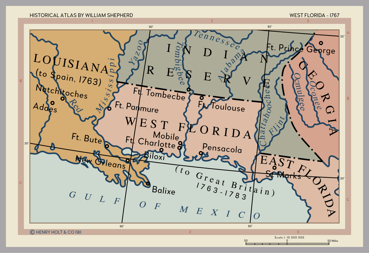
That fort appeared to be in Spanish territory according to that map.
This post was edited on 5/16/23 at 8:05 am
Posted on 5/15/23 at 8:03 pm to fightin tigers
quote:
I trust that. Am I possibly thinking of Fort Iberville?
Choupique just posted the Wiki with the coordinates.
I actually thought it was about 2500' north of this spot but close enough.

Posted on 5/15/23 at 8:19 pm to mikelbr
Wiki might be wrong. But I find it a useful resource while reading history.
Your investigation skills contribute a lot to us. Thanks MikeL.
Your investigation skills contribute a lot to us. Thanks MikeL.
Posted on 5/15/23 at 8:36 pm to mikelbr
Looks like there is a ditch there now according to Google maps. The river is up some so I'm thinking it's under water now.
Posted on 5/15/23 at 9:13 pm to Bigfishchoupique
I wonder if any reseachers went looking for the site during the record low water recently?
Posted on 5/15/23 at 9:24 pm to Redbone
I can't provide a link, but I have read that the fort site is now in the Mississippi River. I had an interest in it as a great grandfather of mine who lived in St James was in the Militia that was part of Galvez's army.
My great grandfather died in IIRC in 1805 and was buried in the St James cemetery but his gravesite and the oldest part of that cemetery is now under the levee .
At that time the Mississippi moved around a good bit, not like now where it is mostly constrained.
My great grandfather died in IIRC in 1805 and was buried in the St James cemetery but his gravesite and the oldest part of that cemetery is now under the levee .
At that time the Mississippi moved around a good bit, not like now where it is mostly constrained.
This post was edited on 5/15/23 at 9:27 pm
Posted on 5/15/23 at 9:30 pm to doublecutter
Yeah, I grew up in Geismar. I saw a few levee moving projects before they put those mats down.

 Page 1 of 1


Back to top