- My Forums
- Tiger Rant
- LSU Recruiting
- SEC Rant
- Saints Talk
- Pelicans Talk
- More Sports Board
- Fantasy Sports
- Golf Board
- Soccer Board
- O-T Lounge
- Tech Board
- Home/Garden Board
- Outdoor Board
- Health/Fitness Board
- Movie/TV Board
- Book Board
- Music Board
- Political Talk
- Money Talk
- Fark Board
- Gaming Board
- Travel Board
- Food/Drink Board
- Ticket Exchange
- TD Help Board
Customize My Forums- View All Forums
- Show Left Links
- Topic Sort Options
- Trending Topics
- Recent Topics
- Active Topics
Started By
Message
(VID) Nicaragua water passage system once allowed Pacific access to America (1600s)
Posted on 12/28/22 at 1:23 pm
Posted on 12/28/22 at 1:23 pm
There has been coincidental recent chatter over a supposed Chicom-built alternative to the Panama canal system proposed for Nicaragua. But guess what? It has supposedly already existed... centuries ago.
Below is PART 2 -- but don't forget to also watch PART 1 (which is only 6 minutes long.)
Part 2: The Panamud Canal Flood Conspiracy and Cover Up

This is one more mind-blower of a share. Well worth watching, baws.
WHO KNEW??

This waterway passage ("discovered" by Spain) is shown on olde maps (pre-1700s) and run from the Atlantic Ocean, through rivers on through Lake Nicaragua, finally reconnecting the journey's last leg into the Pacific Ocean via small river -- which eventually no longer exists. (Timing UNKNOWN)
What might have happened to it?
Many of us find the idea of a worldwide series of cataclysms to be valid (@ 1811-1817) -- one which drastically altered world geography, rivers, created "mudfloods," sunk "mythical" islands. Perhaps the final leg (short river) of this original Nicaragua "canal" system was cut off. (FWIW, the mysterious series World Cataclysms of 1811-1817 is another subject/thread share in the works as well)
 >
>
(ETA: The last Map is from c.1870.)
Library of Congress (LOC)
The pre-Panama Canal passage meant there was exclusive means of access to California and steady two-way stream of transported goods and people TO and FROM the coasts of California and beyond was ongoing for at least 150 years *before* "History" claimed would start buzzing as a result of the (alleged) "Gold Rush".
Coach & wagon? (Anglo-English-speaking people, struggling for grueling months over the plains and through the Rocky Mountains and desert as the sole means to the California and Pacific Ocean?) Doesn't look that way.
It is SPAIN who is said to have found and established this passage AND California (Isn't much of California long been named en Espanol?)
MOTIVATION to keep a secret (theory advanced by Spacebusters): If you've just discovered an easy, exclusively known passage to the wealth and access to California, would you share it with England, France, and others? OR, keep that route under your hat (while NOT mapping out the passage?)
NOTE: There are actually Two Parts to this video series (conducted by Spacebusters with sarcastic good humor.) Please don't forget to watch Part One -- which is only 6 minutes long.
Are you willing to examine valid historical, cartographic, circumstantial and logistical documentation -- evidence that helps makes a super-strong case that access from the Atlantic Ocean thru Nicaragua was not only possible, but the actual case?
Does this mean "history" as we've been told and taught as to who settled where (and especially HOW) in America is totally wrong? Have we been victimized by historical timeline and factual mis-direction again?
YOU decide.
IF alt-theories on history, maps, and dis-trust of the narrative fascinates you, watch, listen, and make your own determination as to whether the offered evidence and dot-connections make this theory plausibility, probable, or...impossible.
Below is PART 2 -- but don't forget to also watch PART 1 (which is only 6 minutes long.)
Part 2: The Panamud Canal Flood Conspiracy and Cover Up
This is one more mind-blower of a share. Well worth watching, baws.
WHO KNEW??
This waterway passage ("discovered" by Spain) is shown on olde maps (pre-1700s) and run from the Atlantic Ocean, through rivers on through Lake Nicaragua, finally reconnecting the journey's last leg into the Pacific Ocean via small river -- which eventually no longer exists. (Timing UNKNOWN)
What might have happened to it?
Many of us find the idea of a worldwide series of cataclysms to be valid (@ 1811-1817) -- one which drastically altered world geography, rivers, created "mudfloods," sunk "mythical" islands. Perhaps the final leg (short river) of this original Nicaragua "canal" system was cut off. (FWIW, the mysterious series World Cataclysms of 1811-1817 is another subject/thread share in the works as well)
> (ETA: The last Map is from c.1870.)
Library of Congress (LOC)
The pre-Panama Canal passage meant there was exclusive means of access to California and steady two-way stream of transported goods and people TO and FROM the coasts of California and beyond was ongoing for at least 150 years *before* "History" claimed would start buzzing as a result of the (alleged) "Gold Rush".
Coach & wagon? (Anglo-English-speaking people, struggling for grueling months over the plains and through the Rocky Mountains and desert as the sole means to the California and Pacific Ocean?) Doesn't look that way.
It is SPAIN who is said to have found and established this passage AND California (Isn't much of California long been named en Espanol?)
MOTIVATION to keep a secret (theory advanced by Spacebusters): If you've just discovered an easy, exclusively known passage to the wealth and access to California, would you share it with England, France, and others? OR, keep that route under your hat (while NOT mapping out the passage?)
NOTE: There are actually Two Parts to this video series (conducted by Spacebusters with sarcastic good humor.) Please don't forget to watch Part One -- which is only 6 minutes long.
Are you willing to examine valid historical, cartographic, circumstantial and logistical documentation -- evidence that helps makes a super-strong case that access from the Atlantic Ocean thru Nicaragua was not only possible, but the actual case?
Does this mean "history" as we've been told and taught as to who settled where (and especially HOW) in America is totally wrong? Have we been victimized by historical timeline and factual mis-direction again?
YOU decide.
IF alt-theories on history, maps, and dis-trust of the narrative fascinates you, watch, listen, and make your own determination as to whether the offered evidence and dot-connections make this theory plausibility, probable, or...impossible.
This post was edited on 12/28/22 at 1:30 pm
 11
11

Posted on 12/28/22 at 1:25 pm to Liberator
PART ONE (link)
This should probably best be view before Part 2 (duh)
VID: Pana-mud Canal Flood (Spacebusters) 6:03
This should probably best be view before Part 2 (duh)
VID: Pana-mud Canal Flood (Spacebusters) 6:03
Posted on 12/28/22 at 1:26 pm to Liberator
quote:On this one, I'll just let you tell me what to think, and I can live with that.
YOU decide
Posted on 12/28/22 at 1:28 pm to Liberator
quote:
YOU decide
Pepsi is better than Coke
Posted on 12/28/22 at 1:31 pm to shel311

Posted on 12/28/22 at 1:32 pm to Liberator
Wake up people
Posted on 12/28/22 at 1:37 pm to mattz1122
quote:
mattz1122
"Wake up people" -- we get it, Game-Boy. It's Mattz's go-to "post-joke" for every thread. Amazing that you're still baiting people with it.
Posted on 12/28/22 at 1:43 pm to Liberator
bookmark
Posted on 12/28/22 at 1:46 pm to Liberator
I know my history pretty well. I can't think of a single account of a pacific passage that didn't involve going to Tierra del Fuego.
I know I've seen maps showing a northwest passage. But again it was never actually there.
I know I've seen maps showing a northwest passage. But again it was never actually there.
Posted on 12/28/22 at 1:56 pm to Liberator
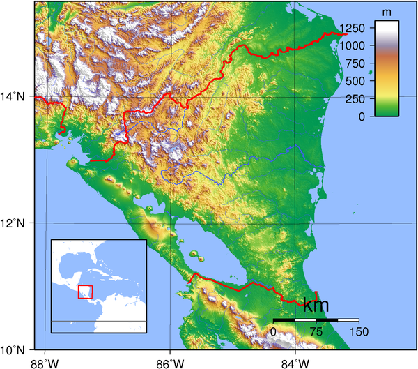
Isn't there a "mountain range" through that area? Would the river have gone up and over the mountains?
Posted on 12/28/22 at 2:08 pm to fightin tigers
quote:
Isn't there a "mountain range" through that area? Would the river have gone up and over the mountains?
Lake Nicaragua sits in a Rift Valley, meaning a navigable waterway to/from it could exist between higher mountain passes without necessitating that travelers go over the mountains. The lake only sits at 108’ above sea level but is situated in such a way that it could theoretically discharge to both coasts if the routes to sea were unimpeded
This post was edited on 12/28/22 at 2:09 pm

Posted on 12/28/22 at 2:11 pm to Liberator
Pangea for the win.
Posted on 12/28/22 at 2:15 pm to Liberator
Uh I’m in agreeance with you
Posted on 12/28/22 at 2:31 pm to Liberator
If you zoom in on the bottom of this map it looks more like a sketch of a proposed canal. There are multiple locks and canals that need to be dug.
If there were all these locks present don’t you think we would see them?
This post was edited on 12/28/22 at 2:31 pm

Posted on 12/28/22 at 2:35 pm to WaWaWeeWa
quote:
If you zoom in on the bottom of this map it looks more like a sketch of a proposed canal. There are multiple locks and canals that need to be dug.
If there were all these locks present don’t you think we would see them?
Right. I thought it was rather well known that this had always been the alternate proposal of how to possibly canal across Central America. Of course, there would have been drawn maps and diagrams of it.
Posted on 12/28/22 at 2:37 pm to Y.A. Tittle
It’s being dug right now by the Chinese
Smithsonian
We could have built it ourselves with the money we sent Ukraine
China is absolutely wrecking us on a global level. There’s a certain president who tried to call attention to it.
Smithsonian
quote:
When construction crews begin digging a new canal this month across Nicaragua, connecting the Pacific and Atlantic, it’ll be a boon to global shipping and, the government says, to the economy of the second-poorest nation in the Americas. But activists, scientists and others are increasingly alarmed by the environmental impact of a 173-mile artificial waterway—wider, deeper and three and a half times the length of the Panama Canal. Developed by Wang Jing, an enigmatic Chinese industrialist with ties to China’s ruling party, the Grand Nicaragua Canal will cost an estimated $40 billion and take five years to build. At 90 feet deep and 1,706 feet across at its widest, the channel will accommodate the newest cargo supertankers, which are longer than the Empire State Building is tall and carry 18,000 shipping containers. The vessels are too big to pass through the Panama Canal (even after a $5 billion expansion is completed) or to dock in any U.S. port.
We could have built it ourselves with the money we sent Ukraine
China is absolutely wrecking us on a global level. There’s a certain president who tried to call attention to it.

Posted on 12/28/22 at 2:38 pm to Liberator
All the answers are in Antarctica
Posted on 12/28/22 at 3:21 pm to fightin tigers
quote:
Isn't there a "mountain range" through that area? Would the river have gone up and over the mountains?
Yes. (The content researcher did address this Snafu in Part 2. I could be wrong but I believe he acknowledged the area elevation is now 500-600 ft)
He also theorizes that in the tumultuous aftermath of a calamity (earthquakes?), the original river route and flow could have also been displaced, rearranged or just disappeared at that time. The cataclysmic upheaval could have possibly resulted in "new" hills and mountains.
Posted on 12/28/22 at 3:28 pm to WaWaWeeWa
That article is from 2014, last I’d heard this project stalled and is unlikely to move forward.
Good thing, Isla de Ometepe is a gem.
Good thing, Isla de Ometepe is a gem.
Posted on 12/28/22 at 3:31 pm to MrWalkingMan
quote:
Lake Nicaragua sits in a Rift Valley, meaning a navigable waterway to/from it could exist between higher mountain passes without necessitating that travelers go over the mountains.
The lake only sits at 108’ above sea level but is situated in such a way that it could theoretically discharge to both coasts if the routes to sea were unimpeded
Given that topographical information (108' elevation) and map, you wonder if its possible for engineers to just trench out rivers that have shifted to flow just below ground? (or diverted into a shallow aquifer?)
You would also think Lidar might be able to sort that whole possibility out -- including depth of the possible "shadow rivers."

 Page 1 of 2

Popular
Back to top