- My Forums
- Tiger Rant
- LSU Recruiting
- SEC Rant
- Saints Talk
- Pelicans Talk
- More Sports Board
- Fantasy Sports
- Golf Board
- Soccer Board
- O-T Lounge
- Tech Board
- Home/Garden Board
- Outdoor Board
- Health/Fitness Board
- Movie/TV Board
- Book Board
- Music Board
- Political Talk
- Money Talk
- Fark Board
- Gaming Board
- Travel Board
- Food/Drink Board
- Ticket Exchange
- TD Help Board
Customize My Forums- View All Forums
- Show Left Links
- Topic Sort Options
- Trending Topics
- Recent Topics
- Active Topics
Started By
Message
re: Tornado! Threat Continues Overnight then Shifts East Tomorrow
Posted on 4/2/17 at 8:45 am to GeauxLSUGRL
Posted on 4/2/17 at 8:45 am to GeauxLSUGRL
quote:
What is/are the best apps for these storms
RadarScope. It's around 10 bucks on the iTunes Store but a great investment.
 2
2

Posted on 4/2/17 at 8:50 am to SouthernHog
What time should Acadia Parish expect the worst weather?

Posted on 4/2/17 at 8:50 am to SouthernHog
quote:several of my coworkers endorse this app but I can't bring myself to pay for something for work. I'd download it the second that my company offered to reimburse me though
RadarScope. It's around 10 bucks on the iTunes Store but a great investment.
Posted on 4/2/17 at 8:52 am to chillbaw
quote:look outside
What time should Acadia Parish expect the worst weather?
I wouldn't rule out another cell or two like that on for Acadia today but you should have a break for at least a good hour before anything else comes through
Posted on 4/2/17 at 8:52 am to baytiger
quote:
several of my coworkers endorse this app but I can't bring myself to pay for something for work. I'd download it the second that my company offered to reimburse me though
I've got it on my laptop, but the latest update causes it to crash every time I click on a warning. To say it is infuriating is an understatement.

Posted on 4/2/17 at 8:54 am to slackster


Posted on 4/2/17 at 8:54 am to slackster
The cell over laffy has some circulation in it now.

Posted on 4/2/17 at 8:55 am to GEAUXmedic
The nerdy dude on Lafayette news last night was saying it wouldn't get bad until tonight. Good call bro.
Posted on 4/2/17 at 8:55 am to baytiger
quote:
you'll see scattered supercells starting around noon becoming more frequent throughout the night. the supercells will be the most dangerous with tornado/hail threat but lots of heavy rain and wind in the overnight and early morning stuff.
The NCAR ensembles seem to show a pretty strong signal for a period of discrete cells with high UH across S. Louisiana b/w 20z - 22z. Mostly north of I10, that might be the biggest risk period for significant tornadoes for that area.
Posted on 4/2/17 at 9:02 am to rds dc
quote:
The NCAR ensembles seem to show a pretty strong signal for a period of discrete cells with high UH across S. Louisiana b/w 20z - 22z. Mostly north of I10, that might be the biggest risk period for significant tornadoes for that area.
I was about to say the same thing.
Posted on 4/2/17 at 9:03 am to baytiger
1 inch hail from that cell over Lafayette right now
Posted on 4/2/17 at 9:04 am to baytiger
quote:
1 inch hail from that cell over Lafayette right now
can confirm
Posted on 4/2/17 at 9:06 am to hendersonshands
The laffy cell is getting a hook.

Posted on 4/2/17 at 9:07 am to hendersonshands
Was not expecting something like this so early.
Posted on 4/2/17 at 9:07 am to baytiger
New watch about to be issued. Also, that cell in southern La could be big trouble if it rides that warm front.
Posted on 4/2/17 at 9:08 am to hendersonshands
If anyone has pictures from today they would let me share, post please. We're having a hard time finding any pics of the hail/storms.
Posted on 4/2/17 at 9:09 am to hendersonshands
It's about quarter size hail in Breaux bridge right now
Posted on 4/2/17 at 9:10 am to rds dc
That cell is putting on a show

Posted on 4/2/17 at 9:12 am to slackster
Pretty sure we've got a tornado on the ground with this cell in Texas.


Posted on 4/2/17 at 9:13 am to slackster
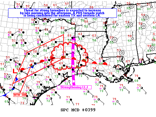
Mesoscale Discussion 0399
NWS Storm Prediction Center Norman OK
0904 AM CDT Sun Apr 02 2017
Areas affected...eastern Texas through extreme western Louisiana
Concerning...Severe potential...Tornado Watch likely
Valid 021404Z - 021630Z
Probability of Watch Issuance...95 percent
SUMMARY...The threat for tornadoes is expected to increase from late
morning into the afternoon over a portion of east TX. A tornado
watch will likely be issued for parts of east TX into western LA by
16Z, and a PDS tornado watch is being considered. The new watch
might also replace the eastern portion of tornado watch 108.
DISCUSSION...Early this morning numerous discrete to semi-discrete
storms including supercells are developing within a zone of warm
advection and isentropic ascent in the vicinity of a warm front
located from southern LA through eastern TX. The storms north of the
warm front are likely slightly elevated, while activity along and
just south of this boundary are probably ingesting
near-surface-based inflow parcels.
Current expectations are for the storms well north of the warm front
to weaken as they move north into the more stable boundary layer
across northeast TX, but may still pose a short term large hail
threat. Visible imagery indicates some diabatic warming may commence
by mid morning over southeast TX, contributing to further boundary
layer destabilization near the warm front. The front should move
slowly north as the low-level jet strengthens across eastern TX into
far western LA in response to forcing for ascent within exit region
of an upper jet rotating through base of synoptic trough. Increasing
0-1 km hodograph size resulting from the strengthening LLJ and
destabilization of the boundary layer should contribute to an
increasing threat for supercells with strong low-level mesocyclones
and tornadoes as storms continue developing in vicinity of the warm
front.

 Page 10 of 52

Popular
Back to top