- My Forums
- Tiger Rant
- LSU Recruiting
- SEC Rant
- Saints Talk
- Pelicans Talk
- More Sports Board
- Coaching Changes
- Fantasy Sports
- Golf Board
- Soccer Board
- O-T Lounge
- Tech Board
- Home/Garden Board
- Outdoor Board
- Health/Fitness Board
- Movie/TV Board
- Book Board
- Music Board
- Political Talk
- Money Talk
- Fark Board
- Gaming Board
- Travel Board
- Food/Drink Board
- Ticket Exchange
- TD Help Board
Customize My Forums- View All Forums
- Show Left Links
- Topic Sort Options
- Trending Topics
- Recent Topics
- Active Topics
Started By
Message
 1
1

Posted on 12/10/21 at 5:22 pm to LegendInMyMind
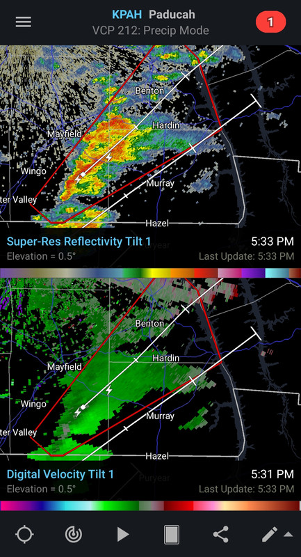
Lightning is a really good hint to watch a cell. Getting ice production in those clouds, telling of a healthier updraft.
Sidebar: my windchill is -11 currently. Which, not really a fan I gotta say.
Sidebar: my windchill is -11 currently. Which, not really a fan I gotta say.
This post was edited on 12/10/21 at 5:24 pm

Posted on 12/10/21 at 5:23 pm to LegendInMyMind
Thanks to all our posters keeping me informed.
I honestly check this OT instead of our local TV guys all the way until we start getting warnings.
Again many thanks.
I honestly check this OT instead of our local TV guys all the way until we start getting warnings.
Again many thanks.
Posted on 12/10/21 at 5:25 pm to Duke
quote:
Lightning is a really good hint to watch a cell. Getting ice production in those clouds, telling of a healthier updraft.
Nothing has really broke 40k feet yet. Still seems kind of capped.
Posted on 12/10/21 at 5:26 pm to Duke
quote:
Sidebar: my windchill is -11 currently. Which, not really a fan I gotta say.
Forgive me if I respectfully decline my share of that.

Posted on 12/10/21 at 5:31 pm to LegendInMyMind
Good luck out there Baw and Bawettes!
Posted on 12/10/21 at 5:33 pm to LegendInMyMind
Western Kentucky first TW of the night.

Posted on 12/10/21 at 5:33 pm to Impotent Waffle
Tornado warning south Graves Co, Ky (my county) near the TN state line.
Livestream sites
WPSD LOCAL 6
KFVS-12
WSIL 3
Livestream sites
WPSD LOCAL 6
KFVS-12
WSIL 3
Posted on 12/10/21 at 5:36 pm to LegendInMyMind
quote:
Nothing has really broke 40k feet yet. Still seems kind of capped
Will get soundings up soon, if not already up. If theres a cap, we ought to see it.
Posted on 12/10/21 at 5:41 pm to Duke
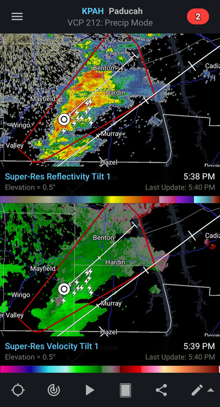
Possible tornado near Lynn Grove in south Calloway Co. it looks like it’ll go south of Murray
Posted on 12/10/21 at 5:42 pm to LegendInMyMind
Note the difference in lightning a few scans later. Also, there's a secondary rotation trying to form under the storm track.
Posted on 12/10/21 at 5:43 pm to LegendInMyMind
I’m in Mayfield according to the radar picture above.
Posted on 12/10/21 at 5:43 pm to LegendInMyMind
Seeing maybe a slight drop on CC.
Posted on 12/10/21 at 5:44 pm to LegendInMyMind
They moved the risk area west in the Ark La Tex area
Posted on 12/10/21 at 5:45 pm to LegendInMyMind
Guys what’s the best way to post a pic/gif? I have tried to help with some RadarScope pics in the past and haven’t been able too.
Posted on 12/10/21 at 5:47 pm to Duke
quote:
Sidebar: my windchill is -11 currently. Which, not really a fan I gotta say.
those are rookie numbers. We had a windchill of -50 a couple weeks back
Posted on 12/10/21 at 5:47 pm to Pisco
This storm in Graves is really close to my Dad’s house, just S of Farmington.
Posted on 12/10/21 at 5:48 pm to SATNIGHTS
quote:
Guys what’s the best way to post a pic/gif? I have tried to help with some RadarScope pics in the past and haven’t been able too.
postimg.cc
I can't remember if you have to make an account. Copy/paste your image to that hosting site, copy the direct link into your reply here.

 Page 8 of 90

Popular
Back to top