




- My Forums
- Tiger Rant
- LSU Recruiting
- SEC Rant
- Saints Talk
- Pelicans Talk
- More Sports Board
- Fantasy Sports
- Golf Board
- Soccer Board
- O-T Lounge
- Tech Board
- Home/Garden Board
- Outdoor Board
- Health/Fitness Board
- Movie/TV Board
- Book Board
- Music Board
- Political Talk
- Money Talk
- Fark Board
- Gaming Board
- Travel Board
- Food/Drink Board
- Ticket Exchange
- TD Help Board
Customize My Forums- View All Forums
- Show Left Links
- Topic Sort Options
- Trending Topics
- Recent Topics
- Active Topics
Started By
Message

Tornado in far south Chicago (near Dyer, IN) moving into Indiana
Posted on 5/27/19 at 4:36 pm

Posted on 5/27/19 at 4:36 pm
 6
6


Posted on 5/27/19 at 4:40 pm to NorthEndZone
The holiday weather female isn't moving to a better time slot anytime soon. There's a possibility that she ignores the massive storm to the immediate east and thinks the little bitty pop up is the tornado.
But, heck, it's Chicago metro and they've got bigger worries.
But, heck, it's Chicago metro and they've got bigger worries.

Posted on 5/27/19 at 4:40 pm to NorthEndZone
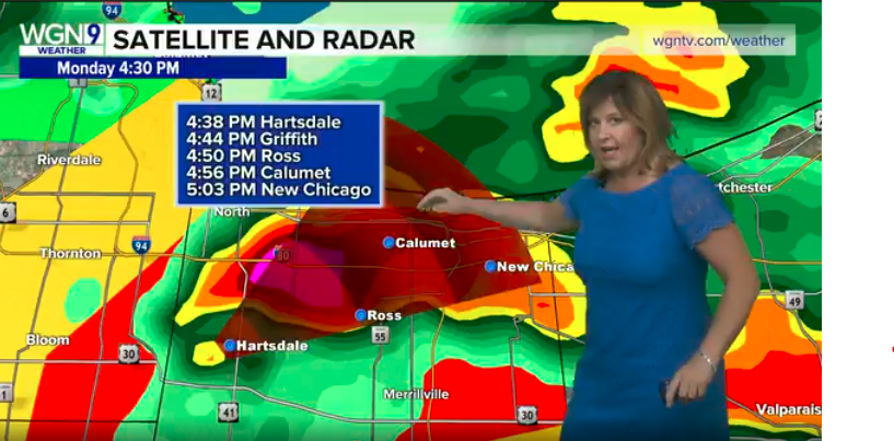
Posted on 5/27/19 at 4:46 pm to LaBR4
They brought in the A-team pretty quickly. Young AA guy and veteran Tom on now. 
This post was edited on 5/27/19 at 4:47 pm

Posted on 5/27/19 at 5:08 pm to NorthEndZone
Tornado heading directly for South Bend. Like heart of town.


Posted on 5/27/19 at 5:12 pm to NorthEndZone
quote:
Tornado in far south Chicago
Its gonna be pissed when it finds out it's not even the most lethal thing in town.
Posted on 5/27/19 at 5:22 pm to slackster
Looks like it's just west of the SB airport now. Heading for northern half of South Bend. Notre Dame could be in the path.
Severe Weather Statement
National Weather Service Northern Indiana
618 PM EDT Mon May 27 2019
INC141-MIC021-027-272245-
/O.CON.KIWX.TO.W.0004.000000T0000Z-190527T2245Z/
St. Joseph IN-Cass MI-Berrien MI-
618 PM EDT Mon May 27 2019
...A TORNADO WARNING REMAINS IN EFFECT UNTIL 645 PM EDT FOR
NORTHEASTERN ST. JOSEPH...SOUTHWESTERN CASS AND SOUTHEASTERN BERRIEN
COUNTIES...
At 616 PM EDT, a severe thunderstorm capable of producing a tornado
was located over South Bend, moving east at 30 mph.
HAZARD...Tornado and quarter size hail.
SOURCE...Weather spotters reported a funnel cloud from Mishawaka and
South Bend.
IMPACT...Flying debris will be dangerous to those caught without
shelter. Mobile homes will be damaged or destroyed. Damage
to roofs, windows, and vehicles will occur. Tree damage is
likely.
This dangerous storm will be near...
Mishawaka and Georgetown around 625 PM EDT.
Granger and Osceola around 635 PM EDT.
Edwardsburg around 640 PM EDT.
Other locations impacted by this tornadic thunderstorm include Barron
Lake, Bertrand, Lydick, Chain-o-lakes and Indian Village.
Severe Weather Statement
National Weather Service Northern Indiana
618 PM EDT Mon May 27 2019
INC141-MIC021-027-272245-
/O.CON.KIWX.TO.W.0004.000000T0000Z-190527T2245Z/
St. Joseph IN-Cass MI-Berrien MI-
618 PM EDT Mon May 27 2019
...A TORNADO WARNING REMAINS IN EFFECT UNTIL 645 PM EDT FOR
NORTHEASTERN ST. JOSEPH...SOUTHWESTERN CASS AND SOUTHEASTERN BERRIEN
COUNTIES...
At 616 PM EDT, a severe thunderstorm capable of producing a tornado
was located over South Bend, moving east at 30 mph.
HAZARD...Tornado and quarter size hail.
SOURCE...Weather spotters reported a funnel cloud from Mishawaka and
South Bend.
IMPACT...Flying debris will be dangerous to those caught without
shelter. Mobile homes will be damaged or destroyed. Damage
to roofs, windows, and vehicles will occur. Tree damage is
likely.
This dangerous storm will be near...
Mishawaka and Georgetown around 625 PM EDT.
Granger and Osceola around 635 PM EDT.
Edwardsburg around 640 PM EDT.
Other locations impacted by this tornadic thunderstorm include Barron
Lake, Bertrand, Lydick, Chain-o-lakes and Indian Village.

Posted on 5/27/19 at 5:24 pm to NorthEndZone
Less than 2 miles away from my good friend

Posted on 5/27/19 at 5:31 pm to NorthEndZone


Posted on 5/27/19 at 5:36 pm to NorthEndZone
Several tornados through the south side of Chicago would be a good thing.


Posted on 5/27/19 at 5:53 pm to LaBR4
Prayers to whom ever is watching that thing on WGN TV.


Posted on 5/27/19 at 6:09 pm to NorthEndZone
I live in a South Bend suburb (Granger) rotation moved on the south side of South Bend (not near ND). There a second line moving in now though that looks bad.
There's radar proof of a tornado on the south side of South Bend, but no spotters confirmed yet. They could see it on the skyview cam, but wasn't definitive enough to confirm. It was some scary shite.
There's radar proof of a tornado on the south side of South Bend, but no spotters confirmed yet. They could see it on the skyview cam, but wasn't definitive enough to confirm. It was some scary shite.
Posted on 5/27/19 at 6:14 pm to TigerFanatic99
Stay safe

Posted on 5/27/19 at 6:14 pm to TigerFanatic99
Hopefully buttgay gets taken out.
Posted on 5/27/19 at 7:03 pm to momentoftruth87
Another tornado just confirmed 30 or 40 miles south east of South Bend between Akron and Gilead.

Posted on 5/27/19 at 7:04 pm to NorthEndZone
It won’t make it out of Chicago Alive.

 Page 1 of 1


Popular
Back to top
 Follow TigerDroppings for LSU Football News