- My Forums
- Tiger Rant
- LSU Recruiting
- SEC Rant
- Saints Talk
- Pelicans Talk
- More Sports Board
- Coaching Changes
- Fantasy Sports
- Golf Board
- Soccer Board
- O-T Lounge
- Tech Board
- Home/Garden Board
- Outdoor Board
- Health/Fitness Board
- Movie/TV Board
- Book Board
- Music Board
- Political Talk
- Money Talk
- Fark Board
- Gaming Board
- Travel Board
- Food/Drink Board
- Ticket Exchange
- TD Help Board
Customize My Forums- View All Forums
- Show Left Links
- Topic Sort Options
- Trending Topics
- Recent Topics
- Active Topics
Started By
Message
re: Tornado! Cards vs Cubs
Posted on 5/7/15 at 3:39 pm to GEAUXmedic

Posted on 5/7/15 at 3:39 pm to GEAUXmedic
STP values from the HRRR for 4pm:

Supercell composite parameters for 4pm:

Supercell composite parameters for 4pm:
This post was edited on 5/7/15 at 3:44 pm
 2
2

Posted on 5/7/15 at 4:09 pm to GEAUXmedic
Looking at the HRRR again for this evening, the ingredients are definitely there for severe weather. The HRRR is the "High Res Rapid Refresh" model, which is an experimental hi res version of the "Rapid Refresh" model, which is a short range model run every hour based on the WRF and GFS models, especially used for severe weather.
I don't feel like typing much but here is a slightly modified explanation I compiled from Jeff Haby's site and apply it to today. Just in case anyone wants to understand models a little more..
First I'll show the CAPE (Convective Available Potential Energy) values:
High CAPE means storms will build vertically very quickly. The updraft speed depends on the CAPE environment.
Hail: As CAPE increases (especially above 2,500 J/kg) the hail potential increases. Large hail requires very large CAPE values.
Downdraft: An intense updraft often produces an intense downdraft since an intense updraft will condense out a large amount of moisture. Expect isolated regions of very heavy rain when storms form in a large or extreme CAPE environment.
Lightning: Large and extreme CAPE will produce storms with abundant lightning.
4. Pitfalls:
a. Storms will only form and the CAPE actualized if the low level capping inversion is broken.
b. CAPE magnitude can rise or fall very rapidly across time and space.
Operational significance of CAPE:
CAPE
1 - 1,500 Positive
1,500 - 2,500 Large
2,500+ Extreme

Next we will look at CIN (Convective Inhibition)
CIN is also known as the cap. You need to break the cap for the lifting to reach the CAPE to form deep convection.
As you can see CIN is non existent for many areas, most likely due to daytime heating..

Next is the LI, or Lifted Index.
A negative LI indicates that the PBL is unstable with respect to the middle troposphere. This is an environment in which convection can occur. The more negative the LI the more unstable the troposphere and the more buoyant the acceleration will be for rising parcels of air from the PBL. Keep in mind the capping layer (CIN) must be broken before lower PBL based lifting is able to move into the +CAPE region of a sounding and develop into deep convection.
LI Values:
Positive number Stable
0 to -4 Marginal instability
-4 to -7 Large instability
-8 or less Extreme instability

Finally, I show you the EHI, or Energy Helicity Index:
The Energy Helicity Index (EHI) is a combination of two indexes. By itself, it is the best index available for tornado prediction since it combines both CAPE and Helicity.
EHI > 1 : Supercell potential
1 to 5 : up to F2, F3 tornadoes possible
5+ : up to F4, F5 tornadoes possible

Couple these ingredients with the immense amount of gulf moisture feeding into the area, I'd say the best chance for severe weather today is in this area:

I don't feel like typing much but here is a slightly modified explanation I compiled from Jeff Haby's site and apply it to today. Just in case anyone wants to understand models a little more..
First I'll show the CAPE (Convective Available Potential Energy) values:
High CAPE means storms will build vertically very quickly. The updraft speed depends on the CAPE environment.
Hail: As CAPE increases (especially above 2,500 J/kg) the hail potential increases. Large hail requires very large CAPE values.
Downdraft: An intense updraft often produces an intense downdraft since an intense updraft will condense out a large amount of moisture. Expect isolated regions of very heavy rain when storms form in a large or extreme CAPE environment.
Lightning: Large and extreme CAPE will produce storms with abundant lightning.
4. Pitfalls:
a. Storms will only form and the CAPE actualized if the low level capping inversion is broken.
b. CAPE magnitude can rise or fall very rapidly across time and space.
Operational significance of CAPE:
CAPE
1 - 1,500 Positive
1,500 - 2,500 Large
2,500+ Extreme
Next we will look at CIN (Convective Inhibition)
CIN is also known as the cap. You need to break the cap for the lifting to reach the CAPE to form deep convection.
As you can see CIN is non existent for many areas, most likely due to daytime heating..
Next is the LI, or Lifted Index.
A negative LI indicates that the PBL is unstable with respect to the middle troposphere. This is an environment in which convection can occur. The more negative the LI the more unstable the troposphere and the more buoyant the acceleration will be for rising parcels of air from the PBL. Keep in mind the capping layer (CIN) must be broken before lower PBL based lifting is able to move into the +CAPE region of a sounding and develop into deep convection.
LI Values:
Positive number Stable
0 to -4 Marginal instability
-4 to -7 Large instability
-8 or less Extreme instability
Finally, I show you the EHI, or Energy Helicity Index:
The Energy Helicity Index (EHI) is a combination of two indexes. By itself, it is the best index available for tornado prediction since it combines both CAPE and Helicity.
EHI > 1 : Supercell potential
1 to 5 : up to F2, F3 tornadoes possible
5+ : up to F4, F5 tornadoes possible
Couple these ingredients with the immense amount of gulf moisture feeding into the area, I'd say the best chance for severe weather today is in this area:
This post was edited on 5/7/15 at 4:11 pm
Posted on 5/7/15 at 4:11 pm to GEAUXmedic
quote:
STP values
I have no idea what these mean...is the higher number worse? I see 15 & 20 in the gulf

Posted on 5/7/15 at 4:13 pm to GEAUXmedic
I don't like the way a lot of those numbers look for NTX.
Posted on 5/7/15 at 4:14 pm to Topwater Trout
quote:
I have no idea what these mean...is the higher number worse? I see 15 & 20 in the gulf
The map youre looking at is the supercell composite parameter, which shows which area has the greatest potential for supercells (not tornados exactly), if the ingredients were in the area.
Posted on 5/7/15 at 4:15 pm to Topwater Trout
quote:
STP values
Damn, though that said SFP at first glance. Was kinda hoping we could friendzone these tornados.
Posted on 5/7/15 at 4:15 pm to LSUGrrrl
Hail in Colorado Springs. TV station said they had to get the snow plows out.

Posted on 5/7/15 at 4:16 pm to GEAUXmedic
Thanks I see my mistake 
Posted on 5/7/15 at 4:16 pm to ptra
That can't all be hail. I've never seen that before.
Posted on 5/7/15 at 4:19 pm to LSUGrrrl
Not to mention... the KFDR Radar went down today...
and look where it's located.

quote:
MESSAGE DATE: MAY 07 2015 18:10:12
KFDR 88D MAINTENANCE IS OUT OF SERVICE. TECHNICIANS HAVE BEEN
NOTIFIED. RESTORATION TIME IS UNKNOWN.FM WFO/OUN 5/7/14 1812 UTC
and look where it's located.

Posted on 5/7/15 at 4:21 pm to GEAUXmedic
Have a friend flying DFW-ORD in an hour, should make for a fun bumpy ride on the 787. I've been keeping an eye on how close his flight gets to some of these storms
Posted on 5/7/15 at 4:25 pm to CuseTiger

quote:
MESOSCALE DISCUSSION 0536
NWS STORM PREDICTION CENTER NORMAN OK
0351 PM CDT THU MAY 07 2015
AREAS AFFECTED...NCNTRL TX AND SRN OK
CONCERNING...SEVERE POTENTIAL...WATCH LIKELY
VALID 072051Z - 072245Z
PROBABILITY OF WATCH ISSUANCE...80 PERCENT
SUMMARY...STRONG TO SEVERE STORMS ARE EXPECTED TO DEVELOP EWD INTO
SRN OK AND NCNTRL TX THIS EVENING. A NEW WW WILL PROBABLY BE NEEDED
WITHIN THE NEXT HOUR OR TWO. PRIMARY THREATS WILL BE LARGE HAIL AND
DAMAGING WIND...BUT A COUPLE TORNADOES CANNOT BE RULED OUT.
DISCUSSION...MCS FROM WRN OK SWWD THROUGH NWRN TX IS MOVING
GENERALLY EWD AT 15 TO 20 KT. OTHER DISCRETE CELLS ARE FORMING IN
NCNTRL TX AHEAD OF THE LINE. OBJECTIVE ANALYSIS INDICATES THE
ATMOSPHERE HAS BECOME MODERATELY TO STRONGLY UNSTABLE WITH 2000-3000
J/KG MLCAPE AND MINIMAL CAP REMAINING. VWP DATA SHOW LOW-LEVEL SHEAR
IS WEAK WITH SMALL HODOGRAPHS. HOWEVER...40-50 KT SHEAR THROUGH A
DEEP LAYER IS SUPPORTIVE OF SUPERCELLS AND STORM ORGANIZATION. THE
STORMS WITHIN THE LINE WILL CONTINUE TO FORWARD PROPAGATE...AND SOME
OF THE DISCRETE CELLS IN WARM SECTOR WILL LIKELY EVOLVE INTO
SUPERCELLS. LARGE HAIL AND DAMAGING WIND WILL REMAIN THE PRIMARY
THREATS WITH THE STRONGER STORMS INTO THE EARLY EVENING. SOME
INCREASE IN THE LLJ WILL OCCUR THIS EVENING WHICH WILL ENHANCE 0-1
KM HODOGRAPHS AND SUPPORT AT LEAST A SMALL WINDOW FOR A FEW
TORNADOES.
Remember just cause there's a severe thunderstorm watch rather than a tornado watch, that doesn't mean you can't have tornadoes.
Posted on 5/7/15 at 4:38 pm to GEAUXmedic
there it is:
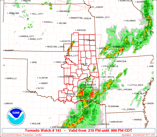
430 PM CDT THU MAY 7 2015
THE NWS STORM PREDICTION CENTER HAS ISSUED A
* SEVERE THUNDERSTORM WATCH FOR PORTIONS OF
SOUTH-CENTRAL OKLAHOMA
NORTH-CENTRAL TEXAS
* EFFECTIVE THIS THURSDAY AFTERNOON FROM 430 PM UNTIL MIDNIGHT
CDT.
* PRIMARY THREATS INCLUDE...
ISOLATED VERY LARGE HAIL EVENTS TO 2.5 INCHES IN DIAMETER
POSSIBLE
ISOLATED DAMAGING WIND GUSTS TO 70 MPH POSSIBLE
A TORNADO OR TWO POSSIBLE
SUMMARY...A NORTH-SOUTH-ORIENTED BAND OF THUNDERSTORMS IS EXPECTED
TO CONTINUE EWD ALONG THE RED RIVER THIS AFTERNOON INTO EVENING.
THE ENVIRONMENT WILL BE SUPPORTIVE OF EMBEDDED SUPERCELL STRUCTURES
WITH A RISK FOR LARGE HAIL...DAMAGING STRAIGHT LINE WINDS AND
PERHAPS A BRIEF TORNADO OR TWO.
THE SEVERE THUNDERSTORM WATCH AREA IS APPROXIMATELY ALONG AND 60
STATUTE MILES EAST AND WEST OF A LINE FROM 70 MILES SOUTHWEST OF
SHERMAN TEXAS TO 30 MILES EAST NORTHEAST OF ARDMORE OKLAHOMA.
FOR A COMPLETE DEPICTION OF THE WATCH SEE THE ASSOCIATED WATCH
OUTLINE UPDATE (WOUS64 KWNS WOU1).
PRECAUTIONARY/PREPAREDNESS ACTIONS...
REMEMBER...A SEVERE THUNDERSTORM WATCH MEANS CONDITIONS ARE
FAVORABLE FOR SEVERE THUNDERSTORMS IN AND CLOSE TO THE WATCH
AREA. PERSONS IN THESE AREAS SHOULD BE ON THE LOOKOUT FOR
THREATENING WEATHER CONDITIONS AND LISTEN FOR LATER STATEMENTS
AND POSSIBLE WARNINGS. SEVERE THUNDERSTORMS CAN AND OCCASIONALLY
DO PRODUCE TORNADOES.
Posted on 5/7/15 at 4:52 pm to GEAUXmedic
I don't have time to deal with this nonsense weather tonight. It's open house night at elementary schools.
Posted on 5/7/15 at 6:07 pm to LSUGrrrl
Open house in May? I'm confused 
Posted on 5/7/15 at 6:07 pm to LSUGrrrl
Tornado Warning NW of DFW

Posted on 5/7/15 at 6:15 pm to GEAUXmedic
Another one:

Posted on 5/7/15 at 6:23 pm to GEAUXmedic
Cells S/SE of DFW could be trouble later, environment across N. Texas is becoming more conducive for tornadoes. Those cells could pass through or very near to eastern DFW before the window closes on tornado potential. Also, any cell that goes up out ahead of the main line could be trouble.

Posted on 5/7/15 at 6:25 pm to GEAUXmedic
god damn you are on top of this shite.
Posted on 5/7/15 at 6:38 pm to bigberg2000
kinda off topic:
anyone feel it?
quote:
@breakingweather 13m13 minutes ago
4.0 magnitude earthquake (depth of 2 miles) 3 miles NNW of Venus, TX, USGS reports: LINK
anyone feel it?

 Page 14 of 28

Popular
Back to top