- My Forums
- Tiger Rant
- LSU Recruiting
- SEC Rant
- Saints Talk
- Pelicans Talk
- More Sports Board
- Winter Olympics
- Fantasy Sports
- Golf Board
- Soccer Board
- O-T Lounge
- Tech Board
- Home/Garden Board
- Outdoor Board
- Health/Fitness Board
- Movie/TV Board
- Book Board
- Music Board
- Political Talk
- Money Talk
- Fark Board
- Gaming Board
- Travel Board
- Food/Drink Board
- Ticket Exchange
- TD Help Board
Customize My Forums- View All Forums
- Show Left Links
- Topic Sort Options
- Trending Topics
- Recent Topics
- Active Topics
Started By
Message
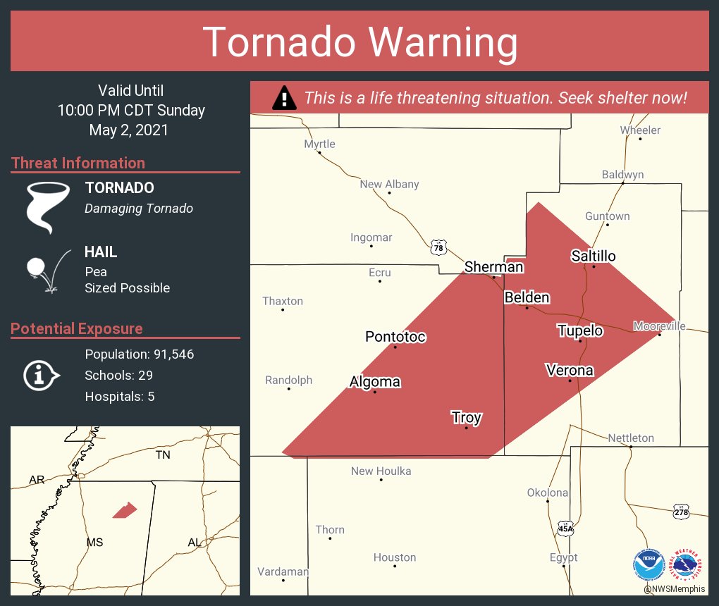
re: Sunday Weather Thread
Posted on 5/2/21 at 9:36 pm to Bobby OG Johnson

Posted on 5/2/21 at 9:36 pm to Bobby OG Johnson
Continues
 3
3

Posted on 5/2/21 at 9:38 pm to Bobby OG Johnson
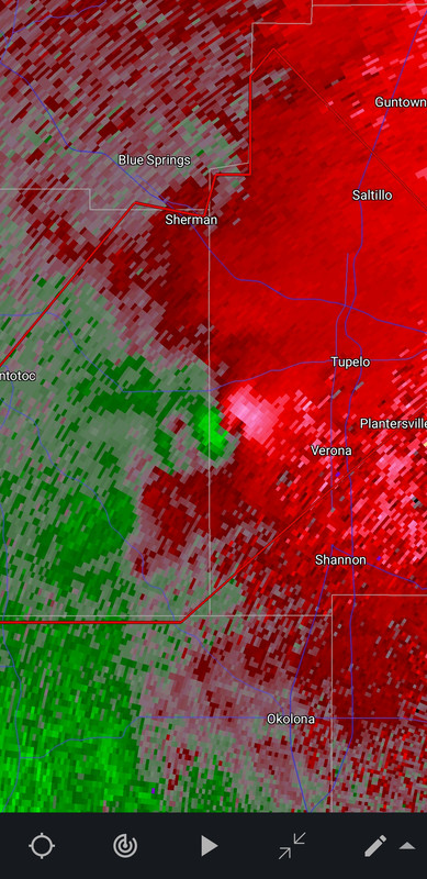
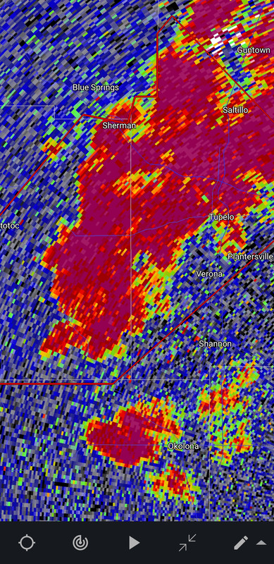
It is a no doubter on radar with that TDS.

Posted on 5/2/21 at 9:40 pm to Bobby OG Johnson
TDS isn’t as apparent now, but they are still saying it’s down.
Posted on 5/2/21 at 9:40 pm to Duke
I did not think that rotation would hold together all the way to Tupelo. Yikes.
That storm, in particular, has been an overachiever.
That storm, in particular, has been an overachiever.
Posted on 5/2/21 at 9:43 pm to LegendInMyMind
that storm has lasted from Yazoo City to Tupelo?
Posted on 5/2/21 at 9:44 pm to Duke
quote:
Duke
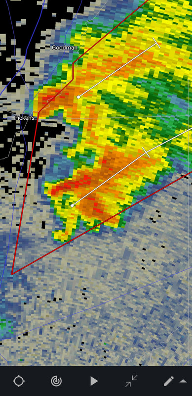
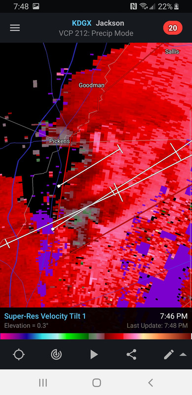
Since you're here, look at this structure from earlier. That little appendage on the south side developed over 3ish frames. It developed a secondary rotation that on Reflectivity looked like it could be anti-cyclonic. Doesn't really look it on Velocity, though. Just thought it was unusual.
Posted on 5/2/21 at 9:45 pm to LegendInMyMind
Still a strong couplet. TDS might be starting to come back.
Posted on 5/2/21 at 9:45 pm to rt3
quote:
that storm has lasted from Yazoo City to Tupelo?
Yep. With significant TDS at multiple times.
Posted on 5/2/21 at 9:47 pm to Bobby OG Johnson
Larger debris signature now
Posted on 5/2/21 at 9:48 pm to Roll Tide Ravens
Has anyone noticed if there have been any Tornado Warnings within today's Enhanced Risk area?
Posted on 5/2/21 at 9:48 pm to Bobby OG Johnson
Sounds like it is heading straight for the TV station
Posted on 5/2/21 at 9:48 pm to LegendInMyMind
TDS is back.
Posted on 5/2/21 at 9:48 pm to Bobby OG Johnson

Posted on 5/2/21 at 9:49 pm to Roll Tide Ravens
Damage in Calhoun City, MS from this same storm that’s approaching Tupelo.
Posted on 5/2/21 at 9:50 pm to Roll Tide Ravens

Posted on 5/2/21 at 9:51 pm to Roll Tide Ravens
quote:
Damage in Calhoun City, MS from this same storm that’s approaching Tupelo.
It was definitely on the ground heading into the town. The TDS was significant then.
Posted on 5/2/21 at 9:52 pm to LegendInMyMind
You can hear the sirens in the background on WTVA.
Posted on 5/2/21 at 9:53 pm to Roll Tide Ravens
quote:
You can hear the sirens in the background on WTVA.
Said earlier it was headed for them
Posted on 5/2/21 at 9:54 pm to Bobby OG Johnson
Emergency!


 Page 10 of 14

Popular
Back to top