- My Forums
- Tiger Rant
- LSU Recruiting
- SEC Rant
- Saints Talk
- Pelicans Talk
- More Sports Board
- Fantasy Sports
- Golf Board
- Soccer Board
- O-T Lounge
- Tech Board
- Home/Garden Board
- Outdoor Board
- Health/Fitness Board
- Movie/TV Board
- Book Board
- Music Board
- Political Talk
- Money Talk
- Fark Board
- Gaming Board
- Travel Board
- Food/Drink Board
- Ticket Exchange
- TD Help Board
Customize My Forums- View All Forums
- Show Left Links
- Topic Sort Options
- Trending Topics
- Recent Topics
- Active Topics
Started By
Message
re: Severe weather thread. 11-5-18
Posted on 11/5/18 at 4:40 pm to Jim Rockford
Posted on 11/5/18 at 4:40 pm to Jim Rockford
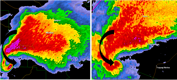
Hello...God speed to all of you in LA this evening. Things seemed to get going fast and they look to be legit and already sparking ground truth. There seems to be a ton of shear with these storm right off...please do not play around with these if you are the type who shrugs storms off. These just have a different dynamic to them today.
I wish all of you the best!!!
I wish all of you the best!!!
 0
0


Posted on 11/5/18 at 4:41 pm to rt3
I'm practicing my radar observation, the one by Stanley looks like circulation, no?
Posted on 11/5/18 at 4:41 pm to slackster
quote:
These tornado warning graphics from Twitter are how I learn about new parts of LA.
Who knew there was an Atlanta, LA?
#frickTheFalcons
now that that's done
Posted on 11/5/18 at 4:42 pm to BHM
quote:
Define obvious.
These things.
Posted on 11/5/18 at 4:43 pm to slackster

Posted on 11/5/18 at 4:44 pm to rt3
Posted on 11/5/18 at 4:44 pm to slackster
quote:
Who knew there was an Atlanta, LA?
There's also a Natchez, LA. our ancestors weren't very creative
Posted on 11/5/18 at 4:45 pm to Pettifogger
quote:
I'm practicing my radar observation, the one by Stanley looks like circulation, no?
Semi-pro tip #1: Use bigger towns as reference points.
I had to look up the Village of Stanley and it's population of 107.
ETA - You were right though. That cell is now warned, heading to Mansfield.
This post was edited on 11/5/18 at 4:46 pm
Posted on 11/5/18 at 4:46 pm to rt3
damn thats a big fricker.
Posted on 11/5/18 at 4:46 pm to rt3

Posted on 11/5/18 at 4:47 pm to slackster
Natchitoches Parish tornado moving into Winn Parish. Current path would take it south of Winnfield.
Posted on 11/5/18 at 4:47 pm to Jim Rockford
quote:
There's also a Natchez, LA. our ancestors weren't very creative
and an Oxford, La.
#GTHOM
Posted on 11/5/18 at 4:48 pm to lsuman25
Posted on 11/5/18 at 4:48 pm to slackster
quote:
Semi-pro tip #1: Use bigger towns as reference points.
haha fair
Posted on 11/5/18 at 4:49 pm to weadjust

Posted on 11/5/18 at 4:50 pm to rt3
That Natchitoches tornado video is pretty damn sizable.
Posted on 11/5/18 at 4:50 pm to rt3
crazy that this is happening on the borderline marginal to slight risk area.
Posted on 11/5/18 at 4:51 pm to rt3
that storm west of Natchitoches heading towards Campti is just dirty... super scary looking
Posted on 11/5/18 at 4:51 pm to rds dc
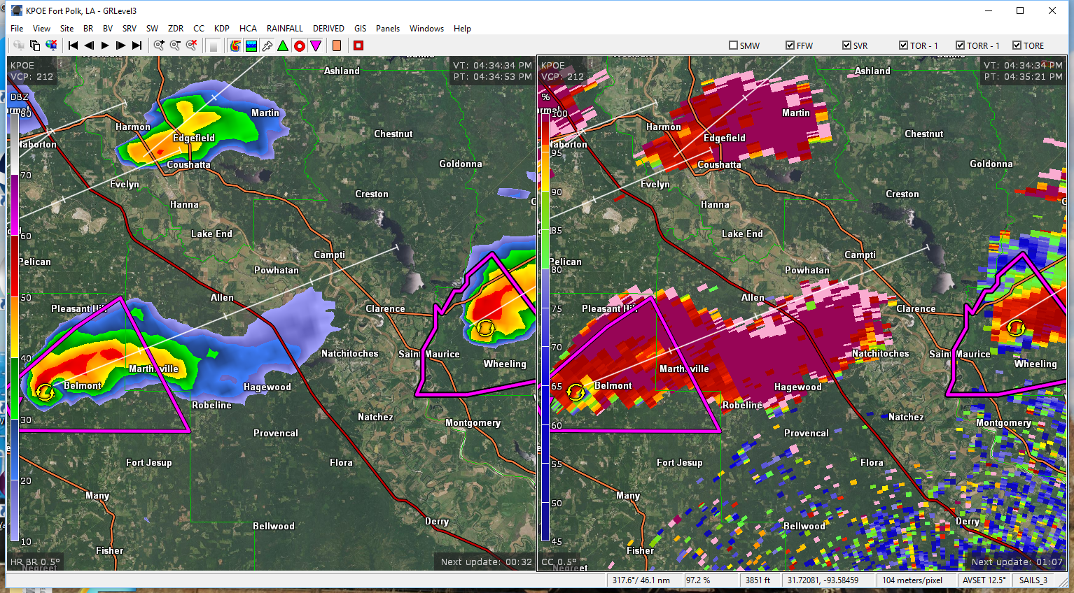
Interesting setup with those cells firing on the leading edge of the best CAPE. The 18z sounding from Shreveport isn't very impressive, highlighting the tight gradient in this setup.

Cells are moving NE as the better thermodynamic environment to the south of them is being advected northward. Shear profiles are supportive of tornadic supercells off to the NE but these cells might outrun the better thermodynamic environment.
Cells are moving NE as the better thermodynamic environment to the south of them is being advected northward. Shear profiles are supportive of tornadic supercells off to the NE but these cells might outrun the better thermodynamic environment.

 Page 2 of 6

Popular
Back to top