- My Forums
- Tiger Rant
- LSU Recruiting
- SEC Rant
- Saints Talk
- Pelicans Talk
- More Sports Board
- Fantasy Sports
- Golf Board
- Soccer Board
- O-T Lounge
- Tech Board
- Home/Garden Board
- Outdoor Board
- Health/Fitness Board
- Movie/TV Board
- Book Board
- Music Board
- Political Talk
- Money Talk
- Fark Board
- Gaming Board
- Travel Board
- Food/Drink Board
- Ticket Exchange
- TD Help Board
Customize My Forums- View All Forums
- Show Left Links
- Topic Sort Options
- Trending Topics
- Recent Topics
- Active Topics
Started By
Message

 0
0

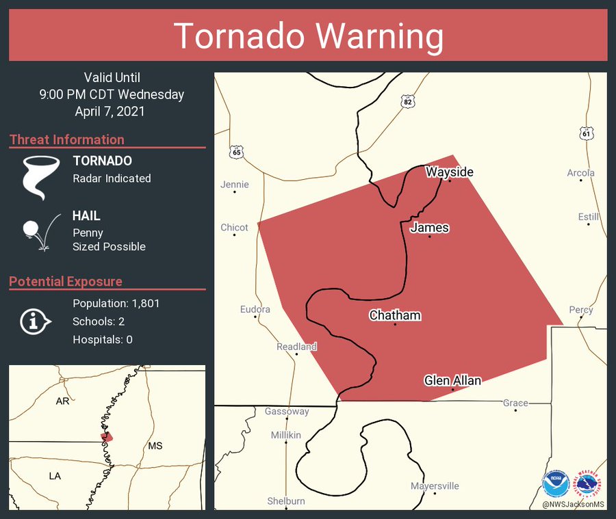
Posted on 4/7/21 at 8:33 pm to Bobby OG Johnson
I wonder if they’ll extend the warning further east
Posted on 4/7/21 at 8:34 pm to deltaland
Tornado or not looks like I’m in for a nice storm in an hour or so.
MS River tends to weaken these some
MS River tends to weaken these some
Posted on 4/7/21 at 8:36 pm to deltaland
quote:
I wonder if they’ll extend the warning further east
They've been slow to all night. Hell, they had "Confirmed tornado on the ground" language, but chose to extend as a Severe Thunderstorm Warning. When they went with a Tornado Warning finally, they just threw it in the middle of the STSW polygon. They must have the B team working tonight.
This post was edited on 4/7/21 at 8:37 pm
Posted on 4/7/21 at 8:43 pm to LegendInMyMind
Who is they in this case? Because the local meteorologists around here are borderline, um, special
Posted on 4/7/21 at 8:44 pm to deltaland
quote:
Who is they in this case?
NWW Jackson
Still better than Memphis a couple weeks ago who issued a tornado warning, posted a polygon, and completely missed the storm with it. They just left it and let the rotation come to it. It was near the MS/AL state line. When it crossed the state line, NWS Huntsville went with a Severe Thunderstorm. That was after NWS Memphis did its whole "there is a tornado" deal in the warning discussion.
This post was edited on 4/7/21 at 9:55 pm
Posted on 4/7/21 at 8:46 pm to deltaland
Jackson. Just pulled in the backside of the warned area without extending the frontside. Radar couplets not looking tight. Hope it means a windy nothingburger for you, but still you stay safe, OK?
Posted on 4/7/21 at 8:50 pm to DoctorTechnical
Still no mention of the spotter confirmation. How the hell do you go "Radar confirmed tornado on the ground" and "there is a tornado on the ground doing damage" to a spotter-confirmed tornado on the ground, with an actual brief TDS on radar, but go back to "a severe thunderstorm capable of producing a tornado"? It makes no sense!

Posted on 4/7/21 at 8:50 pm to DoctorTechnical
Lost power here in cenla at 8:25. Currently studying by a flashlight now.
Posted on 4/7/21 at 8:50 pm to DoctorTechnical
There it is. Just expanded it east and south
Posted on 4/7/21 at 8:51 pm to DoctorTechnical
quote:
Jackson. Just pulled in the backside of the warned area without extending the frontside. Radar couplets not looking tight. Hope it means a windy nothingburger for you, but still you stay safe, OK?
They extended the tornado warning.
Posted on 4/7/21 at 8:52 pm to LegendInMyMind
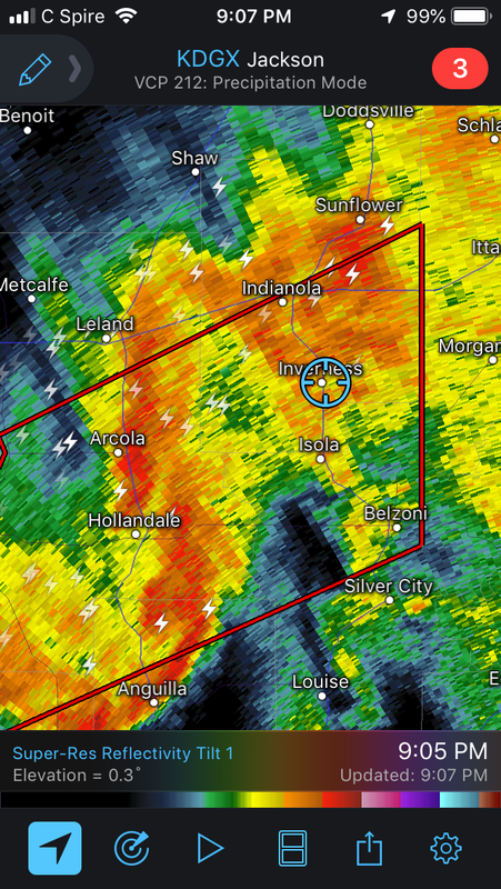
Gonna move over to Columbus radar to take a look...
ETA: still too far away. So why in this modern world do we not have radars spaced every 30 miles or so? Just wondering...
ETA: still too far away. So why in this modern world do we not have radars spaced every 30 miles or so? Just wondering...
This post was edited on 4/7/21 at 8:55 pm
Posted on 4/7/21 at 8:56 pm to DoctorTechnical
KDGX will give you the best look at Velocity. There's a secondary rotation showing up, maybe. It is to the South of the one that has carried the warning.
ETA: My image hosting has shite the bed tonight, so I can't post screen grabs. That, or the internet is just shite where I am.
ETA: My image hosting has shite the bed tonight, so I can't post screen grabs. That, or the internet is just shite where I am.
This post was edited on 4/7/21 at 8:58 pm

Posted on 4/7/21 at 8:57 pm to LegendInMyMind
Morehouse Parish had a tornado or two touch down
Posted on 4/7/21 at 9:00 pm to LegendInMyMind
Possible TDS on the northern rotation.
Posted on 4/7/21 at 9:02 pm to LegendInMyMind
Damn. Can you post the exact location of TDS? Northern one will get very close to me
Posted on 4/7/21 at 9:04 pm to deltaland
Approaching Leland. Given the delay in radar analysis, it's close. Stay safe and let us know if you are OK.

Posted on 4/7/21 at 9:06 pm to deltaland
Enhanced severe zone already for Friday for NE Louisiana and central Mississippi. That's gonna be upped by Friday. Prepare thy bungholes.
Posted on 4/7/21 at 9:06 pm to deltaland
quote:
Damn. Can you post the exact location of TDS? Northern one will get very close to me
Just Southwest of Hollandale. About 3 frames ago.
It looks like the southern rotation is taking over now. NWS Jackson nailed that polygon, though. It accounts for both areas of rotation.
This post was edited on 4/7/21 at 9:07 pm
Posted on 4/7/21 at 9:07 pm to DoctorTechnical
TDS should be near Hollandale not Leland?

 Page 4 of 28

Popular
Back to top