- My Forums
- Tiger Rant
- LSU Recruiting
- SEC Rant
- Saints Talk
- Pelicans Talk
- More Sports Board
- Coaching Changes
- Fantasy Sports
- Golf Board
- Soccer Board
- O-T Lounge
- Tech Board
- Home/Garden Board
- Outdoor Board
- Health/Fitness Board
- Movie/TV Board
- Book Board
- Music Board
- Political Talk
- Money Talk
- Fark Board
- Gaming Board
- Travel Board
- Food/Drink Board
- Ticket Exchange
- TD Help Board
Customize My Forums- View All Forums
- Show Left Links
- Topic Sort Options
- Trending Topics
- Recent Topics
- Active Topics
Started By
Message
 1
1


Posted on 9/13/20 at 1:31 am to biohzrd
One big problem with Sally is it nearly stalls between Monday and Tuesday Nights, it won't be moving very far and wherever the rains do set up it will rain a ton.
If that were to be NOLA it would be very very bad.
If that were to be NOLA it would be very very bad.
Posted on 9/13/20 at 1:42 am to antibarner
Keep those pumps working
Posted on 9/13/20 at 1:43 am to rds dc
Faaackkk

Posted on 9/13/20 at 2:06 am to rds dc
uh oh
Posted on 9/13/20 at 2:18 am to YogaPants
Pressure is dropping
Posted on 9/13/20 at 2:20 am to YogaPants
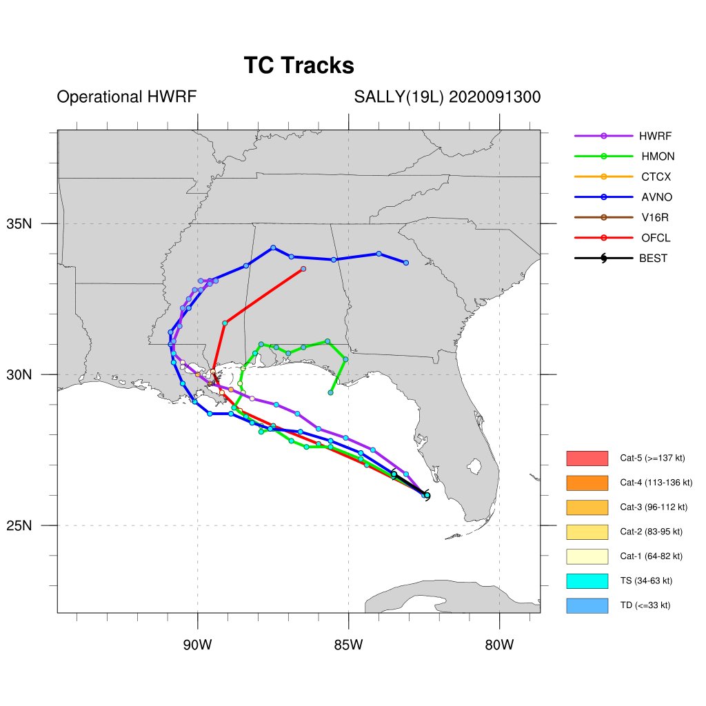
I can’t recall any storms that have taken this approach into SELA, if something like the HWRF verifies. A couple of days of east winds would pile up water East of the Mississippi River and a landfall coming out of that direction with SE winds wrapping around the eyewall would be no bueno.

Posted on 9/13/20 at 2:23 am to YogaPants
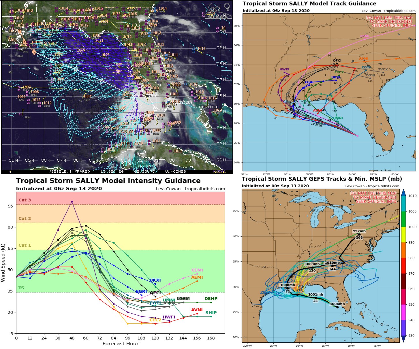
Recon finding 60 mph surface winds. Stronger than expected this soon.


Posted on 9/13/20 at 2:32 am to GEAUXmedic
Looks like rapid intensification is taking place right now which is far sooner than they had predicted. If I recall though the stronger the storm the further north they thought it might go on Saturday is that still the case?
Posted on 9/13/20 at 2:35 am to MrLSU
quote:
Looks like rapid intensification is taking place right now which is far sooner than they had predicted.
No, that’s not what appears to be happening yet. Storm still has a ways to go with respect to her structure before any RI would happen.
Having slightly stronger surface winds in a center that is mostly devoid of any deep convection is not rapid intensification.
Posted on 9/13/20 at 2:35 am to MrLSU
doesn't seem that rapid, most of the convection still sits a distance away from the center

Posted on 9/13/20 at 2:37 am to MrLSU
quote:
Philippe Papin
@pppapin
The beginnings of a nascent inner core may be occurring with #Sally this morning SW of Tampa. Earlier shallow convection wrapped around the llc & is now growing in coverage + intensity.
The last @53rdWRS leg had 57kt 925-hPa FL winds, 52kt SFMR, & 1000-hPa extrapolated pressure.

Posted on 9/13/20 at 2:40 am to Bobby OG Johnson
Posted on 9/13/20 at 2:43 am to MrLSU
TVCN is now over the lake.

Posted on 9/13/20 at 2:45 am to GEAUXmedic
quote:
@zackfradellawx
Not liking what I am seeing during the overnight model runs, small hints of a west shift with more of a track right into SE LA. That could put the greatest threats of heavy rain, long duration wind impacts and coastal surge more centered over Louisiana rather than MS. #lawx
Posted on 9/13/20 at 2:51 am to BRgetthenet
Don’t recall 7 areas of interest on one map. Par for the 2020 course I suppose.

Posted on 9/13/20 at 2:56 am to slackster
quote:
7 areas of interest on one map
quote:
2020

Posted on 9/13/20 at 3:42 am to BRgetthenet
This post was edited on 9/13/20 at 3:45 am
Posted on 9/13/20 at 4:14 am to MrLSU
...SALLY STRENGTHENING...
...HURRICANE AND STORM SURGE WARNINGS ISSUED FOR PORTIONS OF THE
NORTHERN GULF COAST...
SUMMARY OF 500 AM EDT...0900 UTC...INFORMATION
----------------------------------------------
LOCATION...27.0N 84.0W
ABOUT 115 MI...190 KM W OF PORT CHARLOTTE FLORIDA
ABOUT 345 MI...550 KM ESE OF THE MOUTH OF THE MISSISSIPPI RIVER
MAXIMUM SUSTAINED WINDS...50 MPH...85 KM/H
PRESENT MOVEMENT...WNW OR 300 DEGREES AT 13 MPH...20 KM/H
MINIMUM CENTRAL PRESSURE...1001 MB...29.56 INCHES
WATCHES AND WARNINGS
--------------------
CHANGES WITH THIS ADVISORY:
A Storm Surge Warning has been issued from Port Fourchon Louisiana
to Mississippi/Alabama Border.
A Hurricane Warning has been issued from Grand Isle Louisiana
northeast to Ocean Springs Mississippi, including New Orleans,
Lake Pontchartrain and Lake Maurepas.
A Hurricane Watch has been issued from east of Morgan City
Louisiana to west of Grand Isle.
A Tropical Storm Warning has been issued from east of Ocean Springs
Mississippi to Indian Pass Florida.
A Storm Surge Warning is in effect for...
* Port Fourchon Louisiana to the Mississippi/Alabama Border
* Lake Pontchartrain, Lake Maurepas, and Lake Borgne
A Hurricane Warning is in effect for...
* Grand Isle Louisiana to Ocean Springs Mississippi
* Lake Pontchartrain and Lake Maurepas including metropolitan New
Orleans
A Storm Surge Watch is in effect for...
* Mississippi/Alabama Border to the Alabama/Florida Border
A Hurricane Watch is in effect for...
* East of Ocean Springs to the Alabama/Florida Border
A Tropical Storm Warning is in effect for...
* East of Ocean Springs to Indian Pass
A Tropical Storm Watch is in effect for...
* Indian Pass to Ochlockonee River Florida
This post was edited on 9/13/20 at 4:15 am

 Page 44 of 298

Popular
Back to top