- My Forums
- Tiger Rant
- LSU Recruiting
- SEC Rant
- Saints Talk
- Pelicans Talk
- More Sports Board
- Fantasy Sports
- Golf Board
- Soccer Board
- O-T Lounge
- Tech Board
- Home/Garden Board
- Outdoor Board
- Health/Fitness Board
- Movie/TV Board
- Book Board
- Music Board
- Political Talk
- Money Talk
- Fark Board
- Gaming Board
- Travel Board
- Food/Drink Board
- Ticket Exchange
- TD Help Board
Customize My Forums- View All Forums
- Show Left Links
- Topic Sort Options
- Trending Topics
- Recent Topics
- Active Topics
Started By
Message
re: Preliminary Ratings: Lacombe Tornado - EF1; NOLA/Arabi Tornado - EF3
Posted on 3/16/22 at 11:29 pm to LegendInMyMind

Posted on 3/16/22 at 11:29 pm to LegendInMyMind
What does the sounding look like over the Ascension/Livingston area?
 1
1

Posted on 3/16/22 at 11:30 pm to Duke
I cannot for the life of me remember where I was pulling 12 and 24hr Updraft Helicity Swaths from last year. I don't guess I bookmarked it. I haven't checked SPC yet. I like looking at it that way better than just a 6hr swath, and wherever had it I remember being better than others with the look of it.
Posted on 3/16/22 at 11:33 pm to TDsngumbo
quote:
What does the sounding look like over the Ascension/Livingston area?
Not good either. To me, everything east of BR has the tor risk tomorrow.
And legend, check the HREF on the SPC site. I bet that's what youre looking for.
Posted on 3/16/22 at 11:34 pm to Duke
Ok but this is for Friday morning near sunrise, correct?
Posted on 3/16/22 at 11:36 pm to TDsngumbo
Probably straight up overnight for you. Looking near sunrise a little farther east but the threat should increase as it goes east because of the instability loading up.
Posted on 3/16/22 at 11:40 pm to Duke
I'm wondering if I will squeak into another High Risk Tuesday. Right now I don't think so, but I'm betting someone will see it.
Posted on 3/16/22 at 11:43 pm to LegendInMyMind
Action Jackson seems destined.
I was planning to start really digging in to Tuesday tonight and then soon to be day 1 threw a wrench in all that.
Also, really interesting what happened in Birmingham today. 0.8" PWAT and major flash flooding. Some summertime shite with the no steering but just enough instability and good lapse rates to dump rain.
Posted on 3/16/22 at 11:47 pm to Duke
Thanks. I love hurricanes but tornados are a big no for me. They form too fast and are too destructive for my liking. I enjoy a category 1/2 hurricane til the cows come home but frick even a weak tornado.
Posted on 3/16/22 at 11:50 pm to Duke
quote:
Also, really interesting what happened in Birmingham today.
Wanna know how much attention I've been paying? This is the first I've heard of it.
I've gotta get back in gear.
Posted on 3/16/22 at 11:51 pm to Duke
quote:
And legend, check the HREF on the SPC site. I bet that's what youre looking for.
That'll work. It isn't exactly what I had, but it will do. Thanks.
Posted on 3/16/22 at 11:54 pm to Duke
quote:
I was planning to start really digging in to Tuesday tonight and then soon to be day 1 threw a wrench in all that.
Almost like it is March in the Southeast, huh?
I'm not liking the pattern currently. I think we got off light the first half of the month, but this active period heading toward April doesn't bode well. Not unexpected at all, but I'm hoping it doesn't follow the path of similar years.
Posted on 3/17/22 at 12:02 am to LegendInMyMind
quote:
Almost like it is March in the Southeast, huh?
Precisely.
Cutoff low causing all sorts of interesting slight risk days this week. Then getting the best thermo ive seen since the Kentucky outbreak for a nocturnal threat in Louisiana and probably into southern Alabama during the day Friday.
And I too hate what I suspect is lurking beyond.
Posted on 3/17/22 at 2:04 am to Roll Tide Ravens
quote:
Spann mentioned this afternoon that much of Alabama is in a severe weather risk for Day 8. He said that this is only the 6th time since 2012 that they’ve issued a Day 8 risk.
I’m not saying he didn’t do this bc I know you are a good poster for these threads but that just doesn’t sound like Spann’s MO at all.
He always shits on it when outlets try to do their own warnings and stuff like that. He has even pushed to try to get media outlets to use the same or similar graphics when it comes to risk levels and stuff like that
Posted on 3/17/22 at 8:23 am to Wishnitwas1998
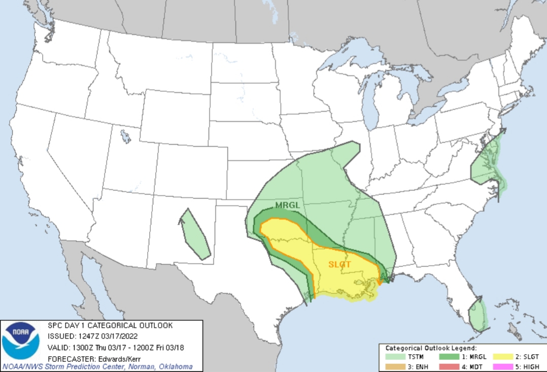
SPC AC 171247
Day 1 Convective Outlook NWS Storm Prediction Center Norman OK 0747 AM CDT Thu Mar 17 2022
Valid 171300Z - 181200Z
...THERE IS A SLIGHT RISK OF SEVERE THUNDERSTORMS LATE THIS AFTERNOON INTO THIS EVENING OVER PARTS OF OKLAHOMA AND NORTH TEXAS...AND LATE TONIGHT IN PARTS OF LOUISIANA AND SOUTHERN MISSISSIPPI...
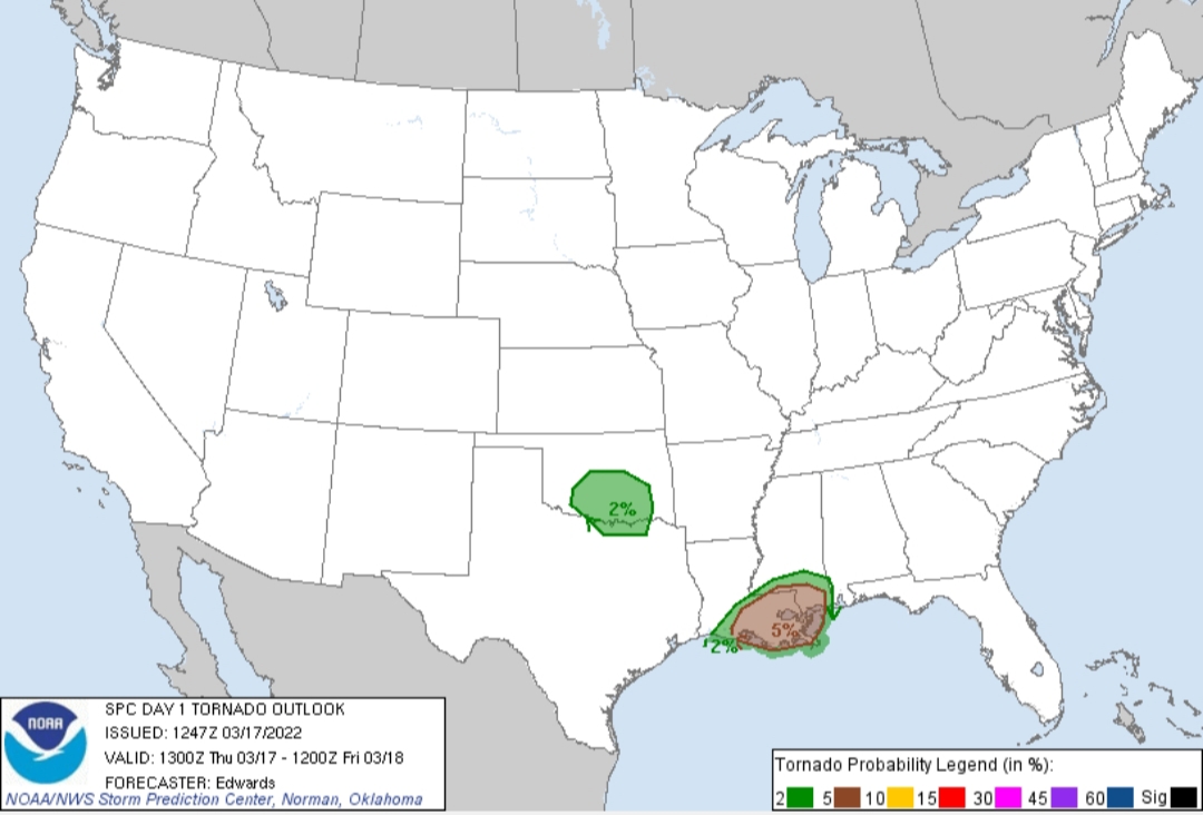
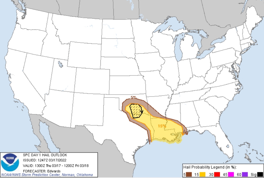
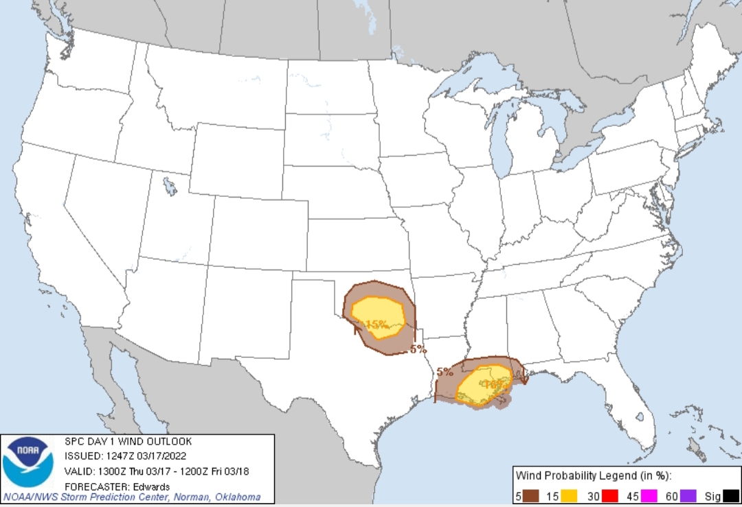
...SUMMARY... Threats for severe thunderstorms are expected late this afternoon into this evening over parts of Oklahoma and north Texas, and late tonight in parts of Louisiana and southern Mississippi. Large hail, damaging winds and a few tornadoes are possible.
...Synopsis... In mid/upper levels, a progressive/split-flow pattern will persist through tomorrow morning, with an especially active southern stream contributing the most to convective potential. A lead shortwave trough, with small/embedded low initially over the CLT area, will eject east-northeastward off the Mid-Atlantic Coast by 00Z. Farther west, a strong shortwave trough is apparent in moisture-channel imagery over the higher terrain of CO/NM. This feature should pivot eastward over the southern High Plains today. By 00Z, the 500-mb trough should extend near a GCK-CDS-DRT axis, with an accompanying low forming over the eastern TX Panhandle. By 12Z, the low should reach the BVO/CNU area, while the trailing trough becomes neutrally to slightly negatively tilted toward the east TX/western LA area.
At the surface, 11Z analysis showed a low over northeastern NC, related to the Carolinas-vicinity mid/upper-level circulation. The associated cold front was drawn across Atlantic waters to near a line from SUA-FMY, across the central Gulf as a stationary to warm front, and westward to lower/middle TX offshore waters. This boundary will move northward across southeast TX this evening and parts of southern LA overnight. By 12Z, it should reach south-central AR, southwestern MS and near MOB.
An elongated area of low pressure was analyzed from east of AMA to near LBB, along a quasistationary frontal zone extending northeastward across northern OK and eastern KS. A cold front extended from the low area roughly westward over central NM. The low is expected to consolidate today and move eastward across parts of northwest TX to southwestern OK by 00Z, with cold front southwestward across the Trans-Pecos region, and dryline across north-central, central and deep south TX. As the low proceeds northeastward to the western Ozarks overnight, the cold front will overtake the dryline, and by 12Z, extend from the low across southwestern AR, to the upper TX coastal plain and deep south TX.
...OK/TX afternoon/evening... Isolated to scattered thunderstorms should develop in an arc late this afternoon over portions of southern OK and north TX, east through southeast of the surface low, and in the low-level convergence maximum near the dryline. Some of that convection may become supercellular, with a threat for large hail and isolated severe gusts. Isolated significant/2-inch+ hail may occur. Unconditional tornado potential is more marginal and uncertain, given the lack of both greater moisture and lower LCL. However, tornado potential cannot be ruled out given the expected strong vertical shear, and potential for mature storms moving into growing hodographs, before they weaken/dissipate late this evening. Low-level hodographs should expand through around 00-02Z over the region with effective SRH reaching the 200-300 J/kg range, before too much nocturnal cooling occurs to support a continued warm- sector/surface-based inflow.
A narrow corridor of favorable surface/diurnal heating is expected ahead of the dryline and surface low this afternoon. Meanwhile, moist advection will continue, albeit in an incomplete return-flow phase, with surface dew points commonly in the 50s F by the time sufficient MLCINH is eroded for late-afternoon convection initiation. As 500-mb temperatures cool to around -20 deg C with the approach of the mid/upper perturbation, a deep layer of steep lapse rates (at least 8 deg C/km from surface to near 400 mb) will develop along and just ahead of the dryline. This will foster a narrow, eastward-moving corridor of around 1000-1500 J/kg MLCAPE -- locally/briefly higher in north TX where low-level forcing will weaken with southward extent past the Metroplex. Nearly half that CAPE could occur within optimal hail-growth zones, with any discrete supercells potentially offering 2-inch hailstones, despite the somewhat limited moisture.
A relative minimum in severe potential may exist between this regime and the LA activity tonight; however, given mesoscale and convection-initiation uncertainties, confidence in a true convective gap is too low to carve out a minimum in unconditional probabilities at this stage.
...LA/MS overnight... Scattered to locally numerous thunderstorms should develop tonight across much of the lower Mississippi Valley/Delta region, in an expansive precipitation area extending northward over more-stable air in the Mid-South. This activity will correspond to a broad zone of low-level warm advection, related large-scale lift, and moisture transport, near and northeast of the surface marine/warm front, with a broad/50-60-kt LLJ. The southern rim of this convection may extend/develop back into the warm sector with some surface-based supercellular involvement. This will include a threat for a few tornadoes, as well as sporadic damaging wind and severe hail.
The most-favorable overlap of buoyancy and vertical shear should be on the warm front, where forecast soundings reasonably suggest dew points in the upper 60s F supporting around 1500 J/kg MLCAPE, with 40-50-kt effective-shear magnitudes, and well-curved hodographs with effective SRH in the 200-400 J/kg range. Any sustained supercells -- from the warm sector through that part of the warm-frontal zone containing surface-based effective-inflow parcels -- will pose the greatest tornado potential. Inflow-layer moisture, mid/upper-level lapse rates, and considerable CAPE in the ideal hail-growth zone, also combine to indicate potential for large hail on either side of the front. A conditional significant-severe threat (hail and/or tornado) may develop the last few hours of the period roughly in the near-coastal BTR-MOB corridor as well. If confidence increases in this scenario's occurrence before the start of the day-2 period, succeeding outlook updates may need to increase probabilities in that area.
..Edwards/Kerr.. 03/17/2022
CLICK TO GET WUUS01 PTSDY1 PRODUCT
NOTE: THE NEXT DAY 1 OUTLOOK IS SCHEDULED BY 1630Z
Day 1 Convective Outlook NWS Storm Prediction Center Norman OK 0747 AM CDT Thu Mar 17 2022
Valid 171300Z - 181200Z
...THERE IS A SLIGHT RISK OF SEVERE THUNDERSTORMS LATE THIS AFTERNOON INTO THIS EVENING OVER PARTS OF OKLAHOMA AND NORTH TEXAS...AND LATE TONIGHT IN PARTS OF LOUISIANA AND SOUTHERN MISSISSIPPI...
...SUMMARY... Threats for severe thunderstorms are expected late this afternoon into this evening over parts of Oklahoma and north Texas, and late tonight in parts of Louisiana and southern Mississippi. Large hail, damaging winds and a few tornadoes are possible.
...Synopsis... In mid/upper levels, a progressive/split-flow pattern will persist through tomorrow morning, with an especially active southern stream contributing the most to convective potential. A lead shortwave trough, with small/embedded low initially over the CLT area, will eject east-northeastward off the Mid-Atlantic Coast by 00Z. Farther west, a strong shortwave trough is apparent in moisture-channel imagery over the higher terrain of CO/NM. This feature should pivot eastward over the southern High Plains today. By 00Z, the 500-mb trough should extend near a GCK-CDS-DRT axis, with an accompanying low forming over the eastern TX Panhandle. By 12Z, the low should reach the BVO/CNU area, while the trailing trough becomes neutrally to slightly negatively tilted toward the east TX/western LA area.
At the surface, 11Z analysis showed a low over northeastern NC, related to the Carolinas-vicinity mid/upper-level circulation. The associated cold front was drawn across Atlantic waters to near a line from SUA-FMY, across the central Gulf as a stationary to warm front, and westward to lower/middle TX offshore waters. This boundary will move northward across southeast TX this evening and parts of southern LA overnight. By 12Z, it should reach south-central AR, southwestern MS and near MOB.
An elongated area of low pressure was analyzed from east of AMA to near LBB, along a quasistationary frontal zone extending northeastward across northern OK and eastern KS. A cold front extended from the low area roughly westward over central NM. The low is expected to consolidate today and move eastward across parts of northwest TX to southwestern OK by 00Z, with cold front southwestward across the Trans-Pecos region, and dryline across north-central, central and deep south TX. As the low proceeds northeastward to the western Ozarks overnight, the cold front will overtake the dryline, and by 12Z, extend from the low across southwestern AR, to the upper TX coastal plain and deep south TX.
...OK/TX afternoon/evening... Isolated to scattered thunderstorms should develop in an arc late this afternoon over portions of southern OK and north TX, east through southeast of the surface low, and in the low-level convergence maximum near the dryline. Some of that convection may become supercellular, with a threat for large hail and isolated severe gusts. Isolated significant/2-inch+ hail may occur. Unconditional tornado potential is more marginal and uncertain, given the lack of both greater moisture and lower LCL. However, tornado potential cannot be ruled out given the expected strong vertical shear, and potential for mature storms moving into growing hodographs, before they weaken/dissipate late this evening. Low-level hodographs should expand through around 00-02Z over the region with effective SRH reaching the 200-300 J/kg range, before too much nocturnal cooling occurs to support a continued warm- sector/surface-based inflow.
A narrow corridor of favorable surface/diurnal heating is expected ahead of the dryline and surface low this afternoon. Meanwhile, moist advection will continue, albeit in an incomplete return-flow phase, with surface dew points commonly in the 50s F by the time sufficient MLCINH is eroded for late-afternoon convection initiation. As 500-mb temperatures cool to around -20 deg C with the approach of the mid/upper perturbation, a deep layer of steep lapse rates (at least 8 deg C/km from surface to near 400 mb) will develop along and just ahead of the dryline. This will foster a narrow, eastward-moving corridor of around 1000-1500 J/kg MLCAPE -- locally/briefly higher in north TX where low-level forcing will weaken with southward extent past the Metroplex. Nearly half that CAPE could occur within optimal hail-growth zones, with any discrete supercells potentially offering 2-inch hailstones, despite the somewhat limited moisture.
A relative minimum in severe potential may exist between this regime and the LA activity tonight; however, given mesoscale and convection-initiation uncertainties, confidence in a true convective gap is too low to carve out a minimum in unconditional probabilities at this stage.
...LA/MS overnight... Scattered to locally numerous thunderstorms should develop tonight across much of the lower Mississippi Valley/Delta region, in an expansive precipitation area extending northward over more-stable air in the Mid-South. This activity will correspond to a broad zone of low-level warm advection, related large-scale lift, and moisture transport, near and northeast of the surface marine/warm front, with a broad/50-60-kt LLJ. The southern rim of this convection may extend/develop back into the warm sector with some surface-based supercellular involvement. This will include a threat for a few tornadoes, as well as sporadic damaging wind and severe hail.
The most-favorable overlap of buoyancy and vertical shear should be on the warm front, where forecast soundings reasonably suggest dew points in the upper 60s F supporting around 1500 J/kg MLCAPE, with 40-50-kt effective-shear magnitudes, and well-curved hodographs with effective SRH in the 200-400 J/kg range. Any sustained supercells -- from the warm sector through that part of the warm-frontal zone containing surface-based effective-inflow parcels -- will pose the greatest tornado potential. Inflow-layer moisture, mid/upper-level lapse rates, and considerable CAPE in the ideal hail-growth zone, also combine to indicate potential for large hail on either side of the front. A conditional significant-severe threat (hail and/or tornado) may develop the last few hours of the period roughly in the near-coastal BTR-MOB corridor as well. If confidence increases in this scenario's occurrence before the start of the day-2 period, succeeding outlook updates may need to increase probabilities in that area.
..Edwards/Kerr.. 03/17/2022
CLICK TO GET WUUS01 PTSDY1 PRODUCT
NOTE: THE NEXT DAY 1 OUTLOOK IS SCHEDULED BY 1630Z
This post was edited on 3/17/22 at 8:28 am
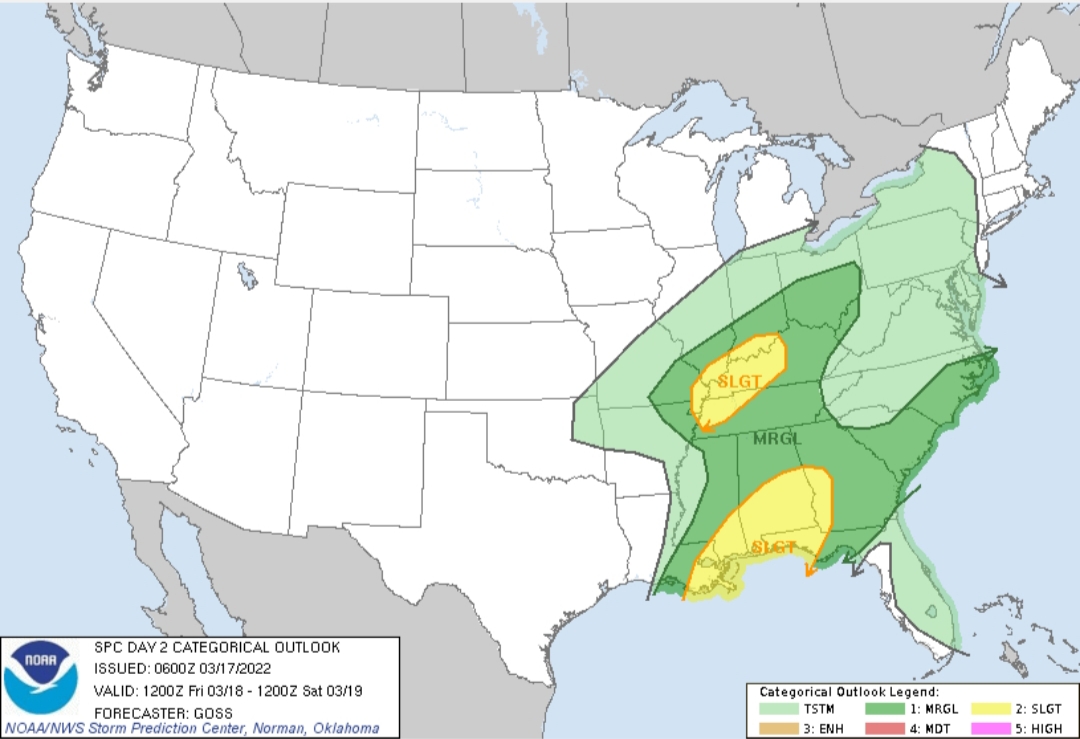
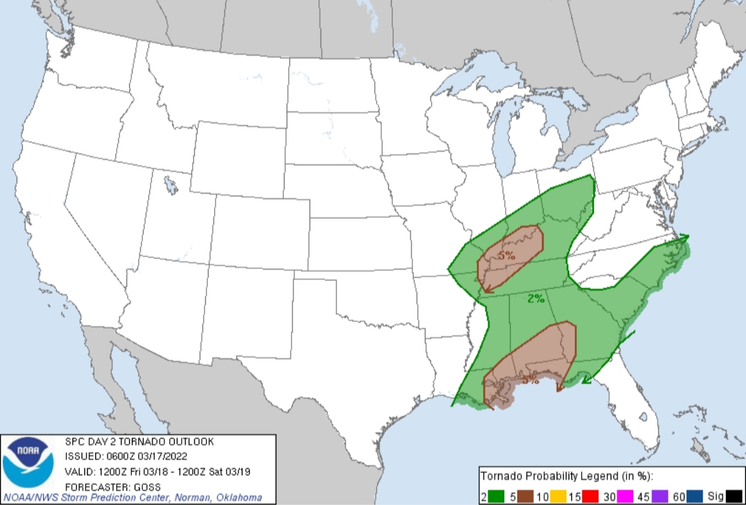
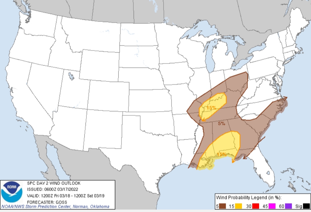
Posted on 3/17/22 at 8:29 am to LegendInMyMind
And the Day 2 Outlook:

This post was edited on 3/17/22 at 8:34 am

Posted on 3/17/22 at 9:01 am to Wishnitwas1998
quote:
I’m not saying he didn’t do this bc I know you are a good poster for these threads but that just doesn’t sound like Spann’s MO at all.
He always shits on it when outlets try to do their own warnings and stuff like that. He has even pushed to try to get media outlets to use the same or similar graphics when it comes to risk levels and stuff like that
I think he just mentioned it to give people a heads up, and just added that a Day 8 risk is fairly rare. I don't think he was trying to hype the event up or say that he already thinks it will be a high end event. In fact, he has said all week that it was too early to be specific about next week's threat for Alabama. As he said even this morning, we need to get through the Friday severe wx threat before we focus too much on next week.
This post was edited on 3/17/22 at 9:03 am
Posted on 3/17/22 at 9:05 am to Wishnitwas1998
quote:
He always shits on it when outlets try to do their own warnings and stuff like that. He has even pushed to try to get media outlets to use the same or similar graphics when it comes to risk levels and stuff like that
He would have been referring to a forecast from the SPC.
Posted on 3/17/22 at 9:12 am to Duke
quote:
He would have been referring to a forecast from the SPC
I'm interested to see if he does what he did last year around this time. While it is true that he knocks outlets putting out their own proprietary outlooks and such, he has done the same.
On a day four or five last year he put out a graphic for Central/South AL that had a Slight Risk area. It was the exact same wording, layout, and graphics as the SPC. The SPC doesn't do a Categorical Outlook beyond day three. Spann knows that, but he put it out anyway and chose to use a format that looked exactly like a SPC Outlook.
I pointed out that what he/they did was the same thing he shits on others for doing and the Spann army beat me for it. They were defending him saying that "The SPC does the same thing", but they don't do the same thing.
I believe that day ended up being an Enhanced Risk day that saw the deadly Lee County tornado.
ETA: He hasn't done that since.
This post was edited on 3/17/22 at 9:13 am
Posted on 3/17/22 at 10:12 am to LegendInMyMind
The timing on this stuff tonight is a double edged sword. It limits instability, which is very good but you hate nocturnal severe weather.
I keep going back and forth if there's enough to ENH SELA. Is slight+ a thing? HRRR doesnt quite destabilize the boundary layer for SELA, and thats really the question. Does the low level flow kill the marine layer and get us mixing at the surface?
IDK
Ive got to say though, looking pretty potent for SE Alabama come late morning Friday.
Posted on 3/17/22 at 10:24 am to LegendInMyMind
I'll second this. Although I will say that as a resident of St Charles Parish, you don't need shite but even less than decent hearing...we have those huge arse sirens that can't help but being heard. And two of my dachshunds love to wail in tandem with them, so I have zero chance of sleeping through this type of event.
If you have an iPhone, be sure your Emergency Alerts are turned on...Settings > Notifications > Scroll down to the bottom to Emergency Alerts. If you've ever had it turned on, and heard that squeal, you'd swear the Zombie Apocalypse was upon us.
If you have an iPhone, be sure your Emergency Alerts are turned on...Settings > Notifications > Scroll down to the bottom to Emergency Alerts. If you've ever had it turned on, and heard that squeal, you'd swear the Zombie Apocalypse was upon us.

 Page 6 of 94

Back to top