- My Forums
- Tiger Rant
- LSU Recruiting
- SEC Rant
- Saints Talk
- Pelicans Talk
- More Sports Board
- Fantasy Sports
- Golf Board
- Soccer Board
- O-T Lounge
- Tech Board
- Home/Garden Board
- Outdoor Board
- Health/Fitness Board
- Movie/TV Board
- Book Board
- Music Board
- Political Talk
- Money Talk
- Fark Board
- Gaming Board
- Travel Board
- Food/Drink Board
- Ticket Exchange
- TD Help Board
Customize My Forums- View All Forums
- Show Left Links
- Topic Sort Options
- Trending Topics
- Recent Topics
- Active Topics
Started By
Message
re: Morganza Spillway may or may not open for a 3rd time -- lack of clear info from ACoE
Posted on 5/28/19 at 10:10 am to Kracka
Posted on 5/28/19 at 10:10 am to Kracka
I am sure this or something like it has been posted. But here is KATC's weather guy showing what is going to happen with the opening of the spillway, and why it's necessary.
KATC - Morganza Spillway
KATC - Morganza Spillway
This post was edited on 5/28/19 at 10:10 am
 4
4


Posted on 5/28/19 at 10:11 am to MountainTiger
quote:
Not sure but I don't think so. The spillway is on the east side of Whiskey Bay Pilot Channel isn't it?
ETA: Maybe they do. The protection levee doesn't go as far south as I thought it did.
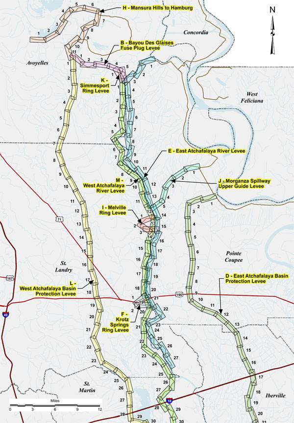
Yeah, the Morganza Spillway is formed by the Atchafalaya's East Levee and the Basin's East Levee with a Levee connecting the Atchafalaya's East levee to high ground/control structure at Morganza to keep the flow from moving North. The Atchafalaya's East levee ends just South of Krotz Springs. Once the river clears the settlements, they pretty much let it go where it wants, though the Atchafalaya's West levee runs further South than its East levee. I think the Atchafalaya's West levee basically runs down through Butte La Rose and ends South of there.
This post was edited on 5/28/19 at 10:18 am
Posted on 5/28/19 at 10:16 am to Kracka
That was very informative and sorta scares the hell out of me.

Posted on 5/28/19 at 10:20 am to TigerstuckinMS
Thanks, yeah I saw that diagram in the other thread. I'm still trying to figure out how that fuse plug levee works. I assume that's the one we were talking about the other day wrt the West Atchafalaya Floodway.

Posted on 5/28/19 at 10:20 am to Kracka
That’s a great description of how everything works. I enjoy going on google earth and looking at everything from a birds eye view.
Posted on 5/28/19 at 10:24 am to sec13rowBBseat28
it looks like there are quite a few camps ON TOP or at least on the other side of the levee from Crotch Springs to Butt Larose

Posted on 5/28/19 at 10:26 am to Kracka
That was a very informative video. Thanks for posting.

Posted on 5/28/19 at 10:27 am to TDsngumbo
It really is. I've never heard a breakdown this in depth about the Morganza
Posted on 5/28/19 at 10:31 am to Kracka
Informative link. Thanks for posting.
Posted on 5/28/19 at 10:33 am to MountainTiger
quote:
I'm still trying to figure out how that fuse plug levee works.
It's just a levee that is designed to be destroyed if it's ever overtopped. It is taller than any expected flooding event, but is shorter than the main levees along the sides of the basin. In the event of an extreme event that threatens to completely fill the basin and spill out of the basin into surrounding areas, water should overtop that fuse plug levee first, break it, and release the basin into the relatively less populated and developed areas near the confluence of the Red and Atchafalaya to catastrophically flood there and give the water more room to fill before it can threaten the main levees and possibly break those and cause a complete loss of control of the lower basin into the far more populous and developed areas further South.
It's very similar to blowing the levees South of New Orleans and letting it flood those people out to save New Orleans, but no dynamite required.
I think.
This post was edited on 5/28/19 at 10:38 am

Posted on 5/28/19 at 10:34 am to tgrbaitn08
quote:they breakin the law.
it looks like there are quite a few camps ON TOP
Are camp owners still bitching about being flooded? I love hearing these people bitch.
Posted on 5/28/19 at 10:35 am to CarRamrod
quote:
Are camp owners still bitching about being flooded? I love hearing these people bitch.
I get a kick out of it too. WTF did they expect? Some folks just love to have something to bitch about.
This post was edited on 5/28/19 at 10:36 am
Posted on 5/28/19 at 10:38 am to CarRamrod
quote:
it looks like there are quite a few camps ON TOP
they breakin the law.
look at the camps on the West side of the spillway between Crotch Springs and Butt Larose....see what I'm talking about?
Posted on 5/28/19 at 10:39 am to TDsngumbo
quote:I think part of it is being ignorant about their camp. Either they dont remember or were never told that, whoever got the land, did so for a fraction of the cost being it was in a spillway and will be flooded during certain times. Being this has only flooded 3 times, they should just consider themselves lucky because this could be a yearly things.
I get a kick out of it too. WTF did they expect? Some folks just love to have something to bitch about.
Posted on 5/28/19 at 10:40 am to tgrbaitn08
quote:ohh i know.... i have walked most of them.
look at the camps on the West side of the spillway between Crotch Springs and Butt Larose....see what I'm talking about?
Idk if they ever would do this but USACE could come out and make these owners removes anything within 15' of the levee. That includes the removal of a camp structure.
I saw a camp that was excavated within the levee up in Missouri. I would guess they did make that guy remove it..... unless he was politically connected.
This post was edited on 5/28/19 at 10:43 am
Posted on 5/28/19 at 10:51 am to TigerstuckinMS
quote:
It's just a levee that is designed to be destroyed if it's ever overtopped.
That part I got but I wasn't sure where it was located and where the floodway was if it ever got overtopped.
According to the diagram you posted, it must be along Bayou des Glaises just outside of Simmesport. For some reason I was trying to put it closer to Mansura. So if the Red ever got high enough it would fill up the area south of Grassy Lake until it got to that fuse plug and then overtop it. After which it would flood the area between Simmesport and the west Atchafalaya protection levee, which is mostly farmland and forest (except for some houses outside the Simmesport ring levee).
LINK
This post was edited on 5/28/19 at 10:57 am
Posted on 5/28/19 at 11:03 am to TDsngumbo
quote:
Are camp owners still bitching about being flooded? I love hearing these people bitch. I get a kick out of it too. WTF did they expect? Some folks just love to have something to bitch about.
I know people with camps in these areas and I’ve not heard any bitching. They all know the consequences and while none are ever happy to see their place flood they know good and well going in that it will happen at some point. Not to say a couple might gripe but by and large these people go through this and just like a lot of South Louisiana they just deal with it. Pulled a couple of truck loads of gear out of Lottie this weekend for a family member.
Posted on 5/28/19 at 11:13 am to MountainTiger
quote:
That part I got but I wasn't sure where it was located and where the floodway was if it ever got overtopped.
According to the diagram you posted, it must be along Bayou des Glaises just outside of Simmesport. For some reason I was trying to put it closer to Mansura. So if the Red ever got high enough it would fill up the area south of Grassy Lake until it got to that fuse plug and then overtop it. After which it would flood the area between Simmesport and the west Atchafalaya protection levee, which is mostly farmland and forest (except for some houses outside the Simmesport ring levee).
Yeah, my understanding is that the whole area around the river in Concordia and Avoyelles parishes is one giant swampy area north of the levee system that the river is allowed to flood into as necessary every year. It's the first line of defense for the lower Mississippi, and is just allowed to naturally flood every year as the rivers swell and then slowly drain back into the river channels as they recede. The Atchafalaya is part of this because the ORCS maintains the 30/70 split in flows between the Atchafalaya and Mississippi. As the Mississippi rises, so must the Atchafalaya. As the Mississippi rises and the Atchafalaya rises with it, that swampy area fills and the rivers fill the batture between their channels and their levees.
If that fills up and the rivers continue to rise, the Bonne Carre is opened first to divert flow into Pontchartrain to both lower the river level at New Orleans and relieve head pressure on the rivers to allow their levels to come down.
If that doesn't appear to be enough to stop the rivers' rise, then the Morganza structure is opened to allow excess water from the Mississippi River side down the East side of the Atchafalaya basin to meet the Atchafalaya River South of Krotz Springs. This water comes from that swampy area that has been allowed to rise. The Morganza structure is normally high and dry, so only if the Mississippi is high enough to flood that swampy area enough to reach the structure can it be used.
If THAT isn't enough to stop the rivers' rise, then the swampy area that's the first line of defense will fill up until it overtops the fuse plug levee, destroying it, and open that floodplain and relieve the Mississippi down the West side of the Basin as well, meeting the Atchafalaya South of Butte La Rose.
If that's not enough, build an ark.
I think.
This post was edited on 5/28/19 at 11:29 am
Posted on 5/28/19 at 11:16 am to TigerstuckinMS
quote:
I think.
I think you're right.
Posted on 5/28/19 at 11:35 am to CarRamrod
quote:
Are camp owners still bitching about being flooded? I love hearing these people bitch.
Are you happy about the people who live there full time bitch about flooding? Or is it just the people who have leisure camps?

 Page 73 of 107

Popular
Back to top