- My Forums
- Tiger Rant
- LSU Recruiting
- SEC Rant
- Saints Talk
- Pelicans Talk
- More Sports Board
- Coaching Changes
- Fantasy Sports
- Golf Board
- Soccer Board
- O-T Lounge
- Tech Board
- Home/Garden Board
- Outdoor Board
- Health/Fitness Board
- Movie/TV Board
- Book Board
- Music Board
- Political Talk
- Money Talk
- Fark Board
- Gaming Board
- Travel Board
- Food/Drink Board
- Ticket Exchange
- TD Help Board
Customize My Forums- View All Forums
- Show Left Links
- Topic Sort Options
- Trending Topics
- Recent Topics
- Active Topics
Started By
Message
re: Harvey ***Catastrophic Flooding Event***
Posted on 8/23/17 at 5:41 am to GEAUXmedic
Posted on 8/23/17 at 5:41 am to GEAUXmedic
I hope that I'm wrong but I get a gut feeling that this will go much further east than they're saying. It's going to slow down, making it easier to be carried or to turn...and if that cold front slows or stalls, it could pick it up.
 1
1


Posted on 8/23/17 at 5:44 am to EastBankTiger
I'm thinking similar to the UKMET path it's been showing.
Posted on 8/23/17 at 5:51 am to GEAUXmedic
quote:
NHC Atlantic Ops @NHC_Atlantic
12m
USAF hurricane hunter aircraft enroute to investigate remnants of #Harvey to determine if it has regenerated to a tropical cyclone. @NOAA
Posted on 8/23/17 at 6:12 am to GEAUXmedic
quote:
Area Forecast Discussion
National Weather Service New Orleans LA
419 AM CDT Wed Aug 23 2017
.SHORT TERM...
Remnants of Harvey beginning to look better this morning. This
system could be the result of a prolonged rainfall event for not
just our area but the entire western half of the gulf coast states.
NHC is giving this system a 90% chance of developing into a tropical
cyclone in 48 hours. And a tropical depression or storm is very
likely to form today. The next thing to look at that will play a
part in what is to come will be the synoptic trough located over
southern Arkansas and northern Mississippi this morning. This trough
will continue to sink southward and stall near the gulf coast. This
trough is also what is causing the weakness in the mid-upper level
ridging that was over the area yesterday. As the tropical system
moves northwest, very deep tropical moisture will be forced
northward on its east side into the stalled trough where plenty of
lift will cause an elongated area of sh/ts to break out initiating
from the tropical cyclone over southeast Texas to the Florida
panhandle. This should begin to be observe Friday or Friday night.
This scenario is expected to continue through the weekend into the
new week as well with rainfall rates slowly increasing over the
weekend into the new week. The tropical feature should slow or even
stall possibly just inland over southeast Texas before getting
picked up in the westerlies starting Sunday night or Monday. As the
low begins to lift, it will do so along the synoptic trough
boundary. Where this boundary is located by Monday should be the
area of heaviest rainfall where it interacts with the low.
The systems exit scenario can not be resolved with any confident
accuracy at the moment since the energy that will pick this
tropical feature up is still located over the Pacific. But the
system that does finally pick it up should begin to be sampled
with the RAOB network by Friday. This will cause the global models
to come into much stronger agreement with respect to the systems
exit. But regardless of naming or any other nomenclature, this
system will have the potential to produce very heavy flooding
rainfall and gusty winds over the entire area as well as high
tides especially west of the Mississippi River. Another
possibility associated with this event will be waterspouts and
tornadic thunderstorms on the east side of the system within the
banding structures. This may depend on how close the low
eventually comes to the area though.
DSS code: Yellow.
Deployed: NOHSEP.
Activation: None.
Activities: DSS support for NOHSEP; Monitoring Convective and
tropical trends.
Decision Support Services (DSS) Code Legend
Green = No weather impacts that require action.
Blue = Long-fused watch, warning, or advisory in effect or
high visibility event.
Yellow = Heightened impacts with short-fused watch, warning or
advisory issuances; radar support.
Orange = High Impacts; Slight to Moderate risk severe; nearby tropical
events; HazMat or other large episodes.
Red = Full engagement for Moderate risk of severe and/or
direct tropical threats; Events of National Significance.
This post was edited on 8/23/17 at 6:25 am
Posted on 8/23/17 at 6:18 am to dukke v
quote:
No worries for the U.S. mainland which is good.... Mexico is gonna get fricking slammed..


Posted on 8/23/17 at 6:21 am to DuckManiak
We fooked
Posted on 8/23/17 at 6:24 am to DuckManiak
quote:
No worries for the U.S. mainland which is good.... Mexico is gonna get fricking slammed..
Don't think it can get repeated enough. This idiot should be permabanned from all weather threads.
Posted on 8/23/17 at 6:27 am to jorconalx
Let's keep him around for the betting threads though. I've made a few bucks doing the opposite.
Posted on 8/23/17 at 6:30 am to iknowmorethanyou
Recon is in

This post was edited on 8/23/17 at 6:35 am
Posted on 8/23/17 at 6:33 am to GEAUXmedic
No ideq what that means but is that a good or bad thing that the blue thingy is pointed straight at Louisiana
Posted on 8/23/17 at 6:33 am to GEAUXmedic
Well that's certainly an eastward spin.
Posted on 8/23/17 at 6:33 am to GEAUXmedic
quote:
@EdValleeWx
3m
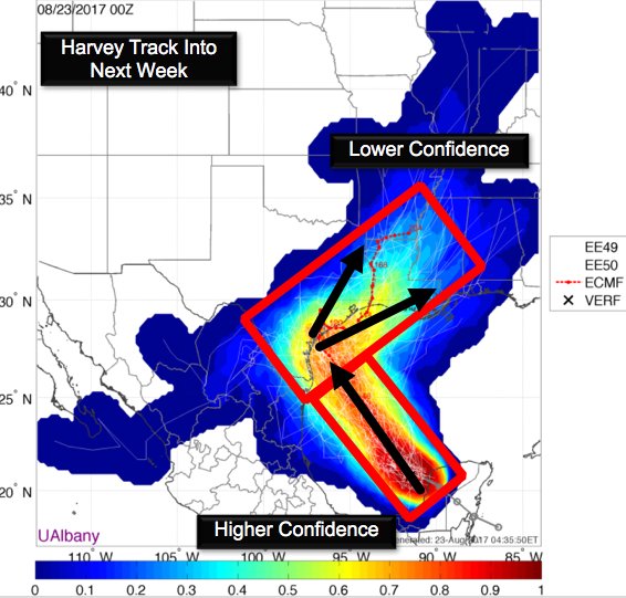
#Harvey track guidance yields high confidence in northwest movement into late week, but confidence decreases next week as it moves northeast

Posted on 8/23/17 at 6:35 am to tke857
That's the flight path into the storm from Biloxi.
Posted on 8/23/17 at 6:35 am to tke857
quote:
No ideq what that means but is that a good or bad thing that the blue thingy is pointed straight at Louisiana
That is just the path the plane took to get to Harvey
Posted on 8/23/17 at 6:36 am to tke857
I know it is extremely early; I know we are going to get it rain; but I don't know if we are going to see 35+mph winds in the Baton Rouge area.
It may sound silly.
But I hate filling up propane bottles only to leave them in the shed forever. With our power lines, I have to assume any storm will bring extended power failure.
Hell power went off last night.
It may sound silly.
But I hate filling up propane bottles only to leave them in the shed forever. With our power lines, I have to assume any storm will bring extended power failure.
Hell power went off last night.
This post was edited on 8/23/17 at 6:38 am
Posted on 8/23/17 at 6:36 am to GEAUXmedic
quote:
Harvey track guidance yields high confidence in northwest movement into late week, but confidence decreases next week as it moves northeast
Well that's one of the most contradictory statements I've seen in awhile
Posted on 8/23/17 at 6:36 am to tke857
So it looks like central Texas landfall.
This post was edited on 8/23/17 at 6:37 am
Posted on 8/23/17 at 6:37 am to GEAUXmedic
Oh ok thanks for clarifying
Posted on 8/23/17 at 6:38 am to X123F45
Bring on the wind. That 20"-35" of rain shite can go straight to hell. If we have another flood like last August I'm moving.
Posted on 8/23/17 at 6:39 am to tke857
quote:
Well that's one of the most contradictory statements I've seen in awhile
Well, no, look at the graphic. There is high confidence Harvey will move northwest towards the texas coast then turn northeast, but there is low confidence where it will go after that turn.

 Page 29 of 618

Back to top