- My Forums
- Tiger Rant
- LSU Recruiting
- SEC Rant
- Saints Talk
- Pelicans Talk
- More Sports Board
- Fantasy Sports
- Golf Board
- Soccer Board
- O-T Lounge
- Tech Board
- Home/Garden Board
- Outdoor Board
- Health/Fitness Board
- Movie/TV Board
- Book Board
- Music Board
- Political Talk
- Money Talk
- Fark Board
- Gaming Board
- Travel Board
- Food/Drink Board
- Ticket Exchange
- TD Help Board
Customize My Forums- View All Forums
- Show Left Links
- Topic Sort Options
- Trending Topics
- Recent Topics
- Active Topics
Started By
Message
A good read on the 33 Category 5 hurricanes on record in the Atlantic since 1924
Posted on 8/31/16 at 5:17 pm

Posted on 8/31/16 at 5:17 pm
LINK
NOAA historical hurricane tracker
NOAA historical hurricane tracker
quote:
There have been 33 Category 5 hurricanes on record in the Atlantic since 1924.
Most Category 5 Atlantic hurricanes have occurred in August and September.
Three Atlantic hurricanes have made landfall in the U.S. as a Category 5.
quote:
In 1980, Hurricane Allen had the highest sustained winds: 190 mph.
Labor Day Hurricane (1935), Hurricane Gilbert (1988) and Hurricane Wilma (2005) had sustained winds of 185 mph.
The lowest air pressure was recorded in Hurricane Wilma (882 mb).
Labor Day Hurricane (1935), Hurricane Camille (1969) and Hurricane Andrew (1992) were the only Category 5 hurricanes to make a recorded landfall in the U.S.
Hurricane Donna (1960) was the only hurricane that produced hurricane-force winds in Florida, the mid-Atlantic states and New England.
Hurricane Camille (1969) made landfall on the coast of Mississippi which is the farthest north.
Cleo (1958), Ethel (1960), Edith (1976) and Emily (2005) are the only four Category 5 Atlantic hurricanes that didn't have their names retired.
 4
4

Posted on 8/31/16 at 5:19 pm to ForeverLSU02
It appears we're experiencing our longest Cat 5 drought (almost 9 years) since 1953

Posted on 8/31/16 at 5:26 pm to ForeverLSU02
quote:
Hurricane Andrew (1992)
Witnessed the destruction first-hand as a volunteer. Like a nuclear bomb was dropped. The most surreal thing I've ever seen in my life.

Posted on 8/31/16 at 5:34 pm to The Quiet One
Where is that picture?
Posted on 8/31/16 at 5:34 pm to CyrustheVirus
Homestead most likely
Posted on 8/31/16 at 5:34 pm to CyrustheVirus
Homestead, Florida

Posted on 8/31/16 at 5:38 pm to ForeverLSU02
quote:
It appears we're experiencing our longest Cat 5 drought (almost 9 years) since 1953
Global cooling.
Posted on 8/31/16 at 6:17 pm to Bestbank Tiger
What was Betsy?
Posted on 8/31/16 at 6:28 pm to nevilletiger79
quote:
What was Betsy?
Cat 3, I believe. Big rainmaker.
Posted on 8/31/16 at 6:35 pm to nevilletiger79
quote:
What was Betsy?
maxed out at cat 4, hit New Orleans as Cat 2/3
Posted on 8/31/16 at 6:38 pm to nevilletiger79
When my grandparents moved to Belle Glade, FL (southeast rim of Lake Okeechobee) in 1932, they were still cleaning up from the 1928 storm. We are fortunate to have the detection, forecasting and response mechanisms in place today to limit damage and deaths. Pre-war storms were just brutal.

Posted on 8/31/16 at 6:41 pm to ForeverLSU02
IIRC, Andrew was only a 3 or 4 just before coming ashore, and it intensified as it approached and was afterwards declared a Cat 5.

Posted on 8/31/16 at 7:00 pm to The Quiet One
That's a mobile home park.

Posted on 8/31/16 at 7:06 pm to ForeverLSU02
quote:
It appears we're experiencing our longest Cat 5 drought (almost 9 years) since 1953
I'm hoping if Trump gets elected he can just run that wall through the gulf and around Florida.
Posted on 8/31/16 at 7:10 pm to LeClerc
quote:
That's a mobile home park.
Well in that case, it isn't all that impressive.
Not a mobile home park...

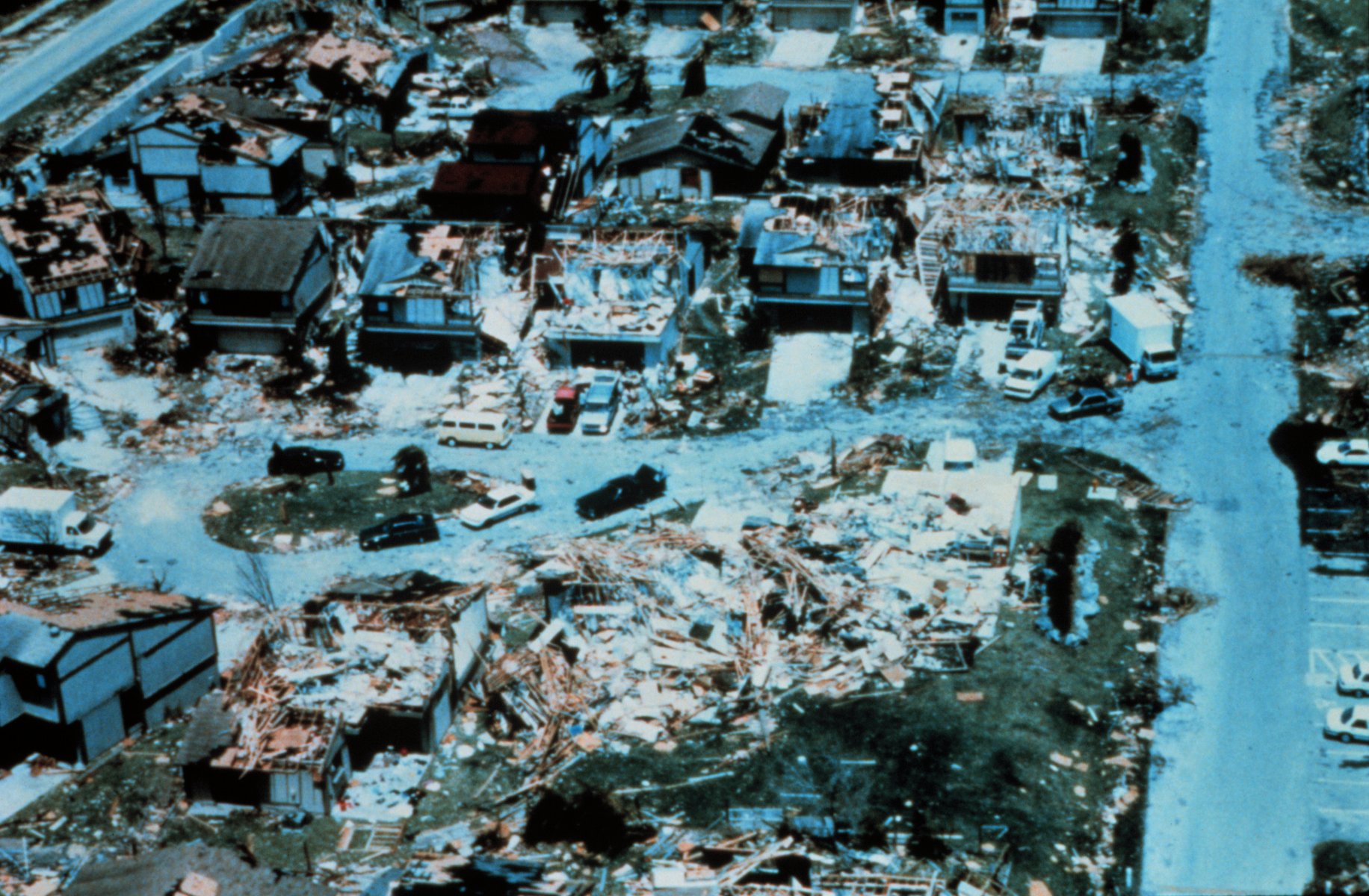
Still a mobile home park, but a worthwhile shot nonetheless:
Posted on 8/31/16 at 7:32 pm to SoFla Tideroller
quote:
When my grandparents moved to Belle Glade, FL (southeast rim of Lake Okeechobee) in 1932, they were still cleaning up from the 1928 storm. We are fortunate to have the detection, forecasting and response mechanisms in place today to limit damage and deaths. Pre-war storms were just brutal.
in the late 1930's a hurricane came onshore on Long Island. it moved over Long Island and into the Long Island sound and over to the Atlantic. it hit Rhode Island as a CAT 3.
no one knew it was coming. we now know it was moving in the ocean at 75 MPH. Your post reminded me.
here is part of the wiki
quote:
Eastern Long Island experienced the worst of the storm. The Dune Road area of Westhampton Beach was obliterated, resulting in 29 deaths. A cinema in Westhampton was also swept out to sea; about 20 people at a matinee and the theater projectionist landed two miles (3 km) into the Atlantic and drowned.[31] There were 21 other deaths through the rest of the East End of Long Island. The storm surge temporarily turned Montauk into an island as it flooded across the South Fork at Napeague and obliterated the tracks of the Long Island Rail Road.
Being exposed to the storm due to its shorelines, Long Island was hit hard. The estimated storm tide was 15 feet in this region. A mean low water storm tide of 8 feet was recorded at Port Jefferson.[8] About 50 people perished in the storm’s wake.[18] All the shore lines were very vulnerable to the high winds and flooding waves, and anyone who was along or near the shores was directly in harm's way.
Ten new inlets were created on eastern Long Island.[8] The surge rearranged the sand at the Cedar Point Lighthouse so that the island became connected to what is now Cedar Point County Park. The surging water created the present-day Shinnecock Inlet by carving out a large section of barrier island separating Shinnecock Bay from the Atlantic. The storm toppled the landmark steeple of the tallest building in Sag Harbor, the Old Whaler's Church.[21] The steeple has not been rebuilt. Wading River suffered substantial damage.
In Greenport, on the North Fork of Long Island, the storm blew down the movie theater located on Front Street.
The fishing industry was destroyed, as was half of the apple crop.[8]
Rhode Island
Damage in Island Park, Rhode Island
Water levels of the 1815 and 1938 hurricanes are marked at Old Market House, Providence
The storm surge hit Westerly, Rhode Island at 3:50 pm EDT, resulting in 100 deaths.[32]
The tide was even higher than usual because of the autumnal equinox and full moon. The hurricane produced storm tides of 14 to 18 feet (5 m) across most of the Long Island and Connecticut coast, with 18 to 25-foot (8 m) tides from New London east to Cape Cod. The storm surge was especially violent along the Rhode Island shore, sweeping hundreds of summer cottages out to sea. Low-lying Block Island offshore was almost completely underwater, and many drowned. As the surge drove northward through Narragansett Bay, it was restricted by the Bay's funnel shape and rose to 15.8 feet above normal spring tides, resulting in more than 13 feet (4.0 m) of water in some areas of downtown Providence. Several motorists were drowned in their autos.[33] Due in part to the economic difficulties of the Great Depression, many stores in downtown Providence were looted by mobs, often before the flood waters had fully subsided.
Many homes and structures along the coast were destroyed, as well as many structures inland along the hurricane's path. Entire beach communities on the coast of Rhode Island were obliterated. Napatree Point, a small cape that housed nearly 40 families between the Atlantic Ocean and Little Narragansett Bay just off of Watch Hill, Rhode Island, was completely swept away. Today, Napatree is a wildlife refuge with no human inhabitants. One house in Charlestown, Rhode Island was lifted and deposited across the street, where it stood, inhabited, until it was demolished in August 2011. Even to this day, concrete staircases and boardwalk bases destroyed by the hurricane can be found when sand levels on some beaches are low.
A few miles from Conanicut Island, Whale Rock Light was swept off its base and into the raging waves, killing keeper Walter Eberle. His body was never found.
At Prudence Island, the Prudence Island Light suffered a direct blow from the storm surge, which measured 17'5" at Sandy Point.
This post was edited on 8/31/16 at 7:34 pm
Posted on 8/31/16 at 7:37 pm to Zach Lee To Amp Hill
How about Hilda? Hit closer to the berry.
Posted on 8/31/16 at 7:41 pm to The Quiet One
quote:
The most surreal thing I've ever seen in my life.
Reminds me of after Katrina.
This post was edited on 1/15/21 at 4:49 pm
Posted on 8/31/16 at 7:50 pm to Bestbank Tiger
I genuinely have no clue how they have so much detail about storms in the 1930s and earlier. This kind of shite is incredible, and probably unreliable too.

Posted on 8/31/16 at 8:10 pm to slackster
They must have extrapolated from land based readings.

 Page 1 of 2

Popular
Back to top