- My Forums
- Tiger Rant
- LSU Recruiting
- SEC Rant
- Saints Talk
- Pelicans Talk
- More Sports Board
- Fantasy Sports
- Golf Board
- Soccer Board
- O-T Lounge
- Tech Board
- Home/Garden Board
- Outdoor Board
- Health/Fitness Board
- Movie/TV Board
- Book Board
- Music Board
- Political Talk
- Money Talk
- Fark Board
- Gaming Board
- Travel Board
- Food/Drink Board
- Ticket Exchange
- TD Help Board
Customize My Forums- View All Forums
- Show Left Links
- Topic Sort Options
- Trending Topics
- Recent Topics
- Active Topics
Started By
Message
re: 2 Apr Severe Weather Potential now in more Eastern areas than Tue
Posted on 4/2/25 at 9:53 am to Roll Tide Ravens

Posted on 4/2/25 at 9:53 am to Roll Tide Ravens
NOAA is predicting the Ohio can get up to about 28 feet (just around moderate flooding range).
Definitely some concern with flash flooding with the rate it'll come down too.
NOAA at Ohio River McAlpine Lock Upper
Definitely some concern with flash flooding with the rate it'll come down too.
NOAA at Ohio River McAlpine Lock Upper
 0
0

Posted on 4/2/25 at 9:59 am to Roll Tide Ravens
quote:
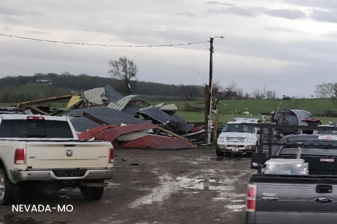
Nasty storm in SW Missouri, near the cities of Nevada and Walker. It has a history of producing a tornado.
Looks as if it did produce a tornado in Moundville and Nevada, MO


Posted on 4/2/25 at 10:51 am to SidewalkTiger
Damn know some good people from nevada
This post was edited on 4/2/25 at 10:51 am

Posted on 4/2/25 at 12:30 pm to OU Guy
Nasty look from the 16z HRRR valid at 7:00 PM CDT this evening. Multiple discrete cells firing out ahead of the main line in northwestern TN and eastern KY.

Posted on 4/2/25 at 12:35 pm to Roll Tide Ravens
We caught the tail end of the line about 6ish this morning...had some energy then and can only imagine as this day/evening unfolds...be safe, people

Posted on 4/2/25 at 12:39 pm to wfallstiger
When did South La. turn into Chicago? The winds lately have been insane.
Posted on 4/2/25 at 12:40 pm to Roll Tide Ravens
quote:
NWS Memphis is calling the forecasted flooding “potentially devastating.”
Isn't a PDS Flood Watch already out for this system?
Posted on 4/2/25 at 12:42 pm to Roll Tide Ravens
An enhanced risk (level 3/5) has been added for tomorrow across many of the same areas that are under the gun today.


Posted on 4/2/25 at 12:44 pm to OU Guy
OU Guy, it might be a good idea to update the thread title to reflect the areas under the gun this afternoon/tonight.
Posted on 4/2/25 at 1:02 pm to Roll Tide Ravens
I don’t see how it doesn’t get bad here, it’s 89 degrees and the wind is ripping but I’m in the slight area
Posted on 4/2/25 at 1:04 pm to Roll Tide Ravens
Dang looks like the weather in Little Rock tomorrow will be fun.
Posted on 4/2/25 at 1:05 pm to Roll Tide Ravens
I can’t always get on here timely during daytime my work throttles it I think. Might want to make a new thread? If I could get on and post easy I would.
Posted on 4/2/25 at 1:07 pm to OU Guy
quote:
can’t always get on here timely during daytime my work throttles it I think. Might want to make a new thread? If I could get on and post easy I would.
Totally understand. I can do that.
Posted on 4/2/25 at 3:46 pm to Roll Tide Ravens
Don't like the way this discrete cell coming into Tennsippibama looks on radar right now. Hopefully it doesn't continue to strengthen bc it has that look about it

 Page 4 of 4


Popular
Back to top