- My Forums
- Tiger Rant
- LSU Recruiting
- SEC Rant
- Saints Talk
- Pelicans Talk
- More Sports Board
- Fantasy Sports
- Golf Board
- Soccer Board
- O-T Lounge
- Tech Board
- Home/Garden Board
- Outdoor Board
- Health/Fitness Board
- Movie/TV Board
- Book Board
- Music Board
- Political Talk
- Money Talk
- Fark Board
- Gaming Board
- Travel Board
- Food/Drink Board
- Ticket Exchange
- TD Help Board
Customize My Forums- View All Forums
- Show Left Links
- Topic Sort Options
- Trending Topics
- Recent Topics
- Active Topics
Started By
Message
 1
1


Posted on 5/28/19 at 11:53 pm to cable
quote:
ok, maybe there was a microburst in the photo. It has nothing to do with the fricking tornado that was in there.
It was, no doubt, a microburst in the pic. Also, not sure you can have a tornado in a microburst...the mechanics of the burst would seem to thwart the development of a tornado...

Posted on 5/28/19 at 11:54 pm to Marco Esquandolas
It was a microburst and there’s another abbreviation for that particular super cell that I learned from a Pecos Hank video that is escaping me atm.
Version one is non rain wrapped
Version two is rain centric
Version three is mixed
I’m sure Duke or one of the Mets can explain better than I.
Version one is non rain wrapped
Version two is rain centric
Version three is mixed
I’m sure Duke or one of the Mets can explain better than I.
Posted on 5/28/19 at 11:56 pm to RummelTiger
quote:
It was, no doubt, a microburst in the pic. Also, not sure you can have a tornado in a microburst...the mechanics of the burst would seem to thwart the development of a tornado...
then I guess it wasn't a microburst. It was definitely a tornado.
Posted on 5/28/19 at 11:58 pm to cable
Quit being obtuse. It’s okay to admit you were wrong. Nobody is going to judge you...too harshly.
Posted on 5/29/19 at 12:02 am to 50_Tiger
quote:
It was a microburst and there’s another abbreviation for that particular super cell that I learned from a Pecos Hank video that is escaping me atm.
Version one is non rain wrapped
Version two is rain centric
Version three is mixed
I’m sure Duke or one of the Mets can explain better than I.
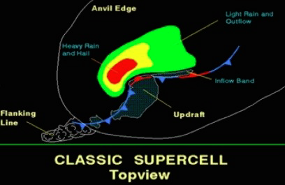
Classic
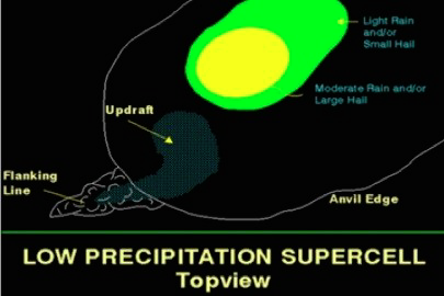
LP (low precipitation)
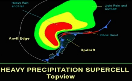
HP (high precipitation)
This post was edited on 5/29/19 at 12:07 am
Posted on 5/29/19 at 12:04 am to RummelTiger
microburst/tornado. Who cares. There are people that lost their homes and are in the local hospitals. I'll be out tomorrow helping my neighbors clean up the debris. You can all play faux meteorologists.
This post was edited on 5/29/19 at 12:05 am
Posted on 5/29/19 at 12:08 am to cable
quote:
microburst/tornado. Who cares.
Well, you, apparently.
quote:
There are people that lost their homes and are in the local hospitals. I'll be out tomorrow helping my neighbors clean up the debris. You can all play faux meteorologists.
Good for you, but you’re barking up the wrong part of the country when it comes to helping neighbors, cleaning debris, etc.
And I don’t “play” a faux meteorologist...I am one.
Posted on 5/29/19 at 12:09 am to RummelTiger
Do you ever hate being an Administrator
Posted on 5/29/19 at 12:12 am to RummelTiger
quote:
Well, you, apparently.
I'm just repeating what 10/10 local mets and the NWS said, including one that chased the storm for 100 miles, but some dude 1000 miles away knows better.
Posted on 5/29/19 at 12:13 am to Sao
No, never hate it...I just try to have fun 99% of the time, but some take this place soooooo seriously.
Posted on 5/29/19 at 12:13 am to cable
I think you're dealing way too much in the semantics of a still photo. That's all these guys are saying
Posted on 5/29/19 at 12:14 am to RummelTiger
so I'm going to assume that the Lawrenceville et al storm tonight was a HP supercell from the photos we've seen
from Wiki
from Wiki
quote:
The HP supercell has a much heavier precipitation core that can wrap all the way around the mesocyclone. These are especially dangerous storms, since the mesocyclone is wrapped with rain and can hide a tornado (if present) from view. These storms also cause flooding due to heavy rain, damaging downbursts and weak tornadoes, although they are also known to produce strong to violent tornadoes. They have a lower potential for damaging hail than Classic and LP supercells, although damaging hail is possible. It has been observed by some spotters that they tend to produce more cloud-to-ground and intracloud lightning than the other types. Also, unlike the LP and Classic types, severe events usually occur at the front (southeast) of the storm. The HP supercell is the most common type of supercell in the United States east of Interstate 35,
Posted on 5/29/19 at 12:16 am to cable
quote:
but some dude 1000 miles away knows better.
I’m actually just 700 miles away...
Posted on 5/29/19 at 12:17 am to RummelTiger
quote:
I’m actually just 700 miles away...
the local mets actually said they had never seen anything like this before.
Posted on 5/29/19 at 12:17 am to RummelTiger
quote:
It was, no doubt, a microburst in the pic. Also, not sure you can have a tornado in a microburst...the mechanics of the burst would seem to thwart the development of a tornado...
A tornado would likely be behind it. They can and do happen in the same supercells.
Posted on 5/29/19 at 12:19 am to cable
Come here, cable...lets hug this shite out.
That’s it...bring it in tight...hold it for a second...and we’re good!
That’s it...bring it in tight...hold it for a second...and we’re good!
Posted on 5/29/19 at 12:19 am to cable
Part of that proclamation was that the top was at 50k feet and one point. Everyone you're fighting with is right and you are too. Don't sweat the small shite.
This post was edited on 5/29/19 at 12:21 am
Posted on 5/29/19 at 12:22 am to RummelTiger
quote:
Come here, cable...lets hug this shite out.
dude, it was a stressful day. Not so much for me, but for the family and neighbors. It was a close call.
Posted on 5/29/19 at 12:24 am to cable
In all sincerity...I’m glad you’re okay, hope your friends and family are, and hope that your community recovers quickly.

 Page 9 of 10

Popular
Back to top