- My Forums
- Tiger Rant
- LSU Recruiting
- SEC Rant
- Saints Talk
- Pelicans Talk
- More Sports Board
- Fantasy Sports
- Golf Board
- Soccer Board
- O-T Lounge
- Tech Board
- Home/Garden Board
- Outdoor Board
- Health/Fitness Board
- Movie/TV Board
- Book Board
- Music Board
- Political Talk
- Money Talk
- Fark Board
- Gaming Board
- Travel Board
- Food/Drink Board
- Ticket Exchange
- TD Help Board
Customize My Forums- View All Forums
- Show Left Links
- Topic Sort Options
- Trending Topics
- Recent Topics
- Active Topics
Started By
Message
re: LA-1 card for Lowrance
Posted on 3/8/19 at 10:07 am to bayouvette

Posted on 3/8/19 at 10:07 am to bayouvette
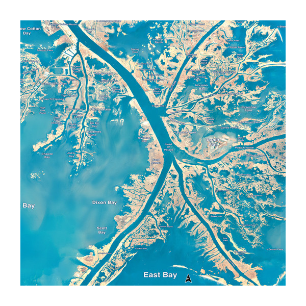
No, I’m talking about stand mapping LA1 card. I’ll post a pic of what there’s supposedly looks like... it looks nothing like a google earth made map card that I have
 2
2

Posted on 3/8/19 at 10:56 am to Uncle JackD
The standard map card is an infrared image. He uses it to have a contrast between land and water. You can find his maps on gonvernment websites. However you cant download the georeferencing data to use them on your lowrance. This is why you need SAS planet. The guy who runs standard has a background of map making and developed these maps
Yall will see when making maps that in the sun it is hard to distinguish muddy marsh water and land.
Pro tip: if using arcgis or google style maps you need to play with the contrast settings. Bing maps have much better contrast
Yall will see when making maps that in the sun it is hard to distinguish muddy marsh water and land.
Pro tip: if using arcgis or google style maps you need to play with the contrast settings. Bing maps have much better contrast
This post was edited on 3/9/19 at 4:06 am
Posted on 3/8/19 at 3:14 pm to Uncle JackD
quote:
No, I’m talking about stand mapping LA1 card. I’ll post a pic of what there’s supposedly looks like... it looks nothing like a google earth made map card that I have
That odd blue colored map is only visible at certain zoom ranges. When you zoom in close enough for the map to be useful the image changes colors and gets worse.

 Page 1 of 1


Popular
Back to top