- My Forums
- Tiger Rant
- LSU Recruiting
- SEC Rant
- Saints Talk
- Pelicans Talk
- More Sports Board
- Fantasy Sports
- Golf Board
- Soccer Board
- O-T Lounge
- Tech Board
- Home/Garden Board
- Outdoor Board
- Health/Fitness Board
- Movie/TV Board
- Book Board
- Music Board
- Political Talk
- Money Talk
- Fark Board
- Gaming Board
- Travel Board
- Food/Drink Board
- Ticket Exchange
- TD Help Board
Customize My Forums- View All Forums
- Show Left Links
- Topic Sort Options
- Trending Topics
- Recent Topics
- Active Topics
Started By
Message
Storm Aftermath - Hurricane Matthew will be Retired
Posted on 9/20/16 at 2:18 pm
Posted on 9/20/16 at 2:18 pm


Model Times - Tropical Tidbits
GFS:
00z - 10:30 pm
06z - 4:30 am
12z - 10:30 am
18z - 4:30 pm
Euro:
00z - 12:45 am
12z - 12:45 pm
This post was edited on 10/10/16 at 10:07 pm
 39
39


Posted on 9/20/16 at 2:19 pm to rds dc
So...we're not going to die?
Posted on 9/20/16 at 2:20 pm to rds dc
looks like i'll wait another year to get my generator serviced
Posted on 9/20/16 at 2:29 pm to rds dc

I typically don't give much time to pouch tracking but P39L is very intriguing. The current MJO forecast and medium range model guidance would suggest a general westward motion. The last few systems have come off of Africa farther north and have been automatic out to sea systems.
The models are in pretty good agreement that P39L will be approaching the Islands in 8 or 9 days with a ridge over the top. At this time, there are a lot of signals pointing to a late season heatwave in the East. That would suggest stronger than normal high pressure over the SE that might keep any future system trapped on a westward course.

Posted on 9/20/16 at 2:31 pm to udtiger
quote:
So...we're not going to die?
Depends on how intense the fighting over Miles becomes.
This post was edited on 9/20/16 at 2:34 pm

Posted on 9/20/16 at 2:33 pm to rds dc
Punta Cana... Here I come!!
Posted on 9/20/16 at 9:52 pm to jlu03
quote:
Punta Cana... Here I come!!
Got stuck on the train the other day next to a women that was talking on her phone about going to Punta Cana. Needless to say, I nearly lost it
Posted on 9/20/16 at 10:17 pm to rds dc
The 12z models today are still latching on to P39L and developing it in a week or so. It is actually still over Africa:
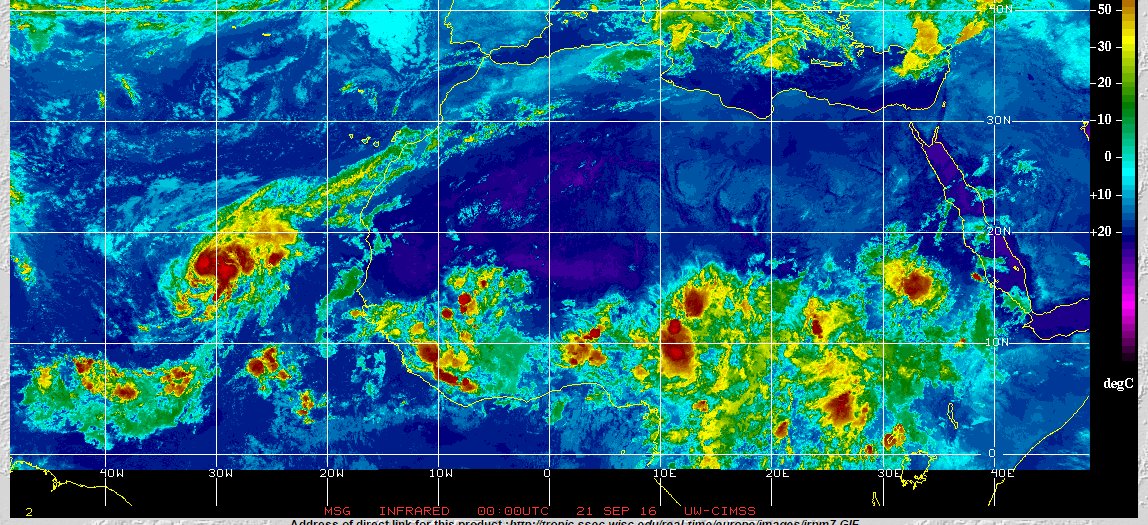
It should stay weak as it moves westward across the Basin with conditions being pretty unfavorable overall:
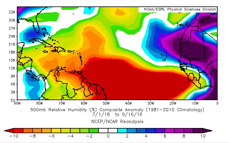
The red contours and brownish orange shading show that the Atlantic could be dominated by dry sinking air over the next week or so. This fits right in with the theme of this season with the MDR being full of dry sinking air:
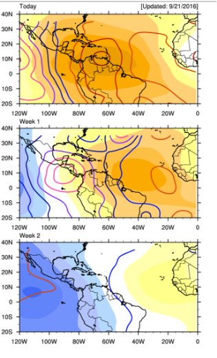
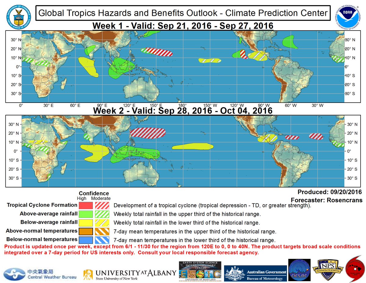
Conditions are forecast to improve over the WCAB and Gulf as we move through the 2nd week of the upcoming period. This appears to be what the models are picking up on but they actually try to get things started in about 7 days or so, which might be a little bit rushed. However, the Climate Prediction Center is highlighting the Islands for development in Week 2:
Regardless, a long ways off but something to watch with both the 12z GFS and Euro having a system at D10:


And they are both supported by the corresponding ensemble runs. The 12z Euro EPS isn't as aggressive as the GEFS but is highlighting a similar area by D10:

An interesting analog of a late season system that came across really low would be Lili from 2002 that peaked as a Cat 4:

It should stay weak as it moves westward across the Basin with conditions being pretty unfavorable overall:
The red contours and brownish orange shading show that the Atlantic could be dominated by dry sinking air over the next week or so. This fits right in with the theme of this season with the MDR being full of dry sinking air:
Conditions are forecast to improve over the WCAB and Gulf as we move through the 2nd week of the upcoming period. This appears to be what the models are picking up on but they actually try to get things started in about 7 days or so, which might be a little bit rushed. However, the Climate Prediction Center is highlighting the Islands for development in Week 2:
Regardless, a long ways off but something to watch with both the 12z GFS and Euro having a system at D10:
And they are both supported by the corresponding ensemble runs. The 12z Euro EPS isn't as aggressive as the GEFS but is highlighting a similar area by D10:
An interesting analog of a late season system that came across really low would be Lili from 2002 that peaked as a Cat 4:

Posted on 9/20/16 at 10:19 pm to rds dc
I thought everyone said we'd have humanity ending hurricanes with all this global warming and shite?
Posted on 9/20/16 at 10:22 pm to rds dc
This is my last hurricane season in New Orleans 
This post was edited on 9/20/16 at 10:23 pm
Posted on 9/20/16 at 10:30 pm to jimbeam
quote:
I thought everyone said we'd have humanity ending hurricanes with all this global warming and shite?
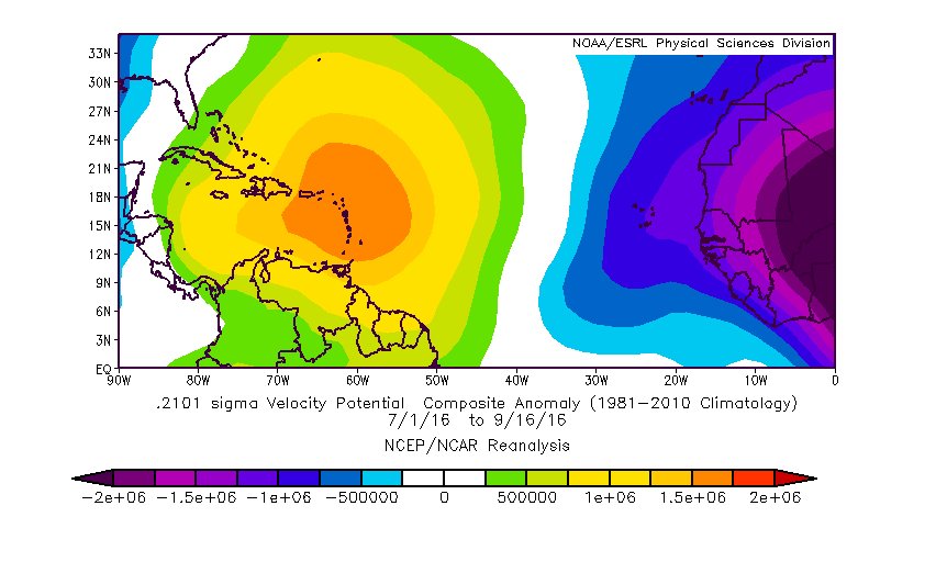
I'm not getting into here but there is growing evidence/research that the warming of the oceans globally may actually be hampering cyclone develop in the Atlantic MDR. Globally, ocean temps continue to be well above normal but Northern Hemisphere ACE is basically at normal with the Atlantic being about 25% below normal.

Posted on 9/20/16 at 10:55 pm to rds dc
So, how far off were the "preseason" estimates off from actual?
My guess is close to the number of named storms, but too high on the number of major hurricanes, since I'm not sure we got one this season.
Yet.
My guess is close to the number of named storms, but too high on the number of major hurricanes, since I'm not sure we got one this season.
Yet.
Posted on 9/21/16 at 7:44 am to East Coast Band
quote:
So, how far off were the "preseason" estimates off from actual?
My guess is close to the number of named storms, but too high on the number of major hurricanes, since I'm not sure we got one this season.
Yet.
IIRC, most people who put out seasonal forecast went with above normal activity. We are at 12 named storms right now and that is the avg. for a season. However, the season is about 25% below normal for ACE.
The 00z GFS is trying to crank some ACE on this next system

Posted on 9/22/16 at 2:10 pm to rds dc
P39L is now showing up in the NHC outlook:


Posted on 9/22/16 at 2:14 pm to rds dc
seriously, is PC going to be effected next week? I really am going there 
Posted on 9/22/16 at 2:35 pm to tgrbaitn08
quote:
seriously, is PC going to be effected next week? I really am going there
Really no way to tell, the 12z models range from the Euro & UK being week and down near S. America to the GFS showing this:

I would probably lean towards the weaker solutions at this point.
Posted on 9/22/16 at 4:02 pm to rds dc
Surprisingly good agreement between the 12z Euro and Euro EPS that P39L will be in the WCAB and poised to turn towards the Gulf at D10:


Posted on 9/22/16 at 4:15 pm to rds dc
dude - i love reading your posts with the diagrams - thx for making them.
Posted on 9/23/16 at 8:11 am to rds dc
There continues to be good agreement across the models that P39L could be an issue in the WCAB in 8 to 10 days. Obviously, model forecast at that range are of low confidence but there are reasons to believe that these might not be as low as normal. Development in WCAB matches Climo for the timeframe and the large scale pattern depicted by the models matches up nicely with global teleconnections.
00z GFS at 240hrs

00z Euro at 240hrs

The setup shown in both models would suggest at turn to the Gulf after that. Still a long ways off and probably only of interest to wx nerds at this point.
00z GFS at 240hrs
00z Euro at 240hrs
The setup shown in both models would suggest at turn to the Gulf after that. Still a long ways off and probably only of interest to wx nerds at this point.
Posted on 9/23/16 at 8:35 am to rds dc
a 917 mb central pressure would be a pretty strong storm.

 Page 1 of 181

Popular
Back to top