- My Forums
- Tiger Rant
- LSU Recruiting
- SEC Rant
- Saints Talk
- Pelicans Talk
- More Sports Board
- Fantasy Sports
- Golf Board
- Soccer Board
- O-T Lounge
- Tech Board
- Home/Garden Board
- Outdoor Board
- Health/Fitness Board
- Movie/TV Board
- Book Board
- Music Board
- Political Talk
- Money Talk
- Fark Board
- Gaming Board
- Travel Board
- Food/Drink Board
- Ticket Exchange
- TD Help Board
Customize My Forums- View All Forums
- Show Left Links
- Topic Sort Options
- Trending Topics
- Recent Topics
- Active Topics
Started By
Message
re: Storm Tracking Thread: Post Tropical Storm Hermine
Posted on 8/26/16 at 6:34 pm to theunknownknight

Posted on 8/26/16 at 6:34 pm to theunknownknight
quote:
Saw this on FB
Link?
 1
1

Posted on 8/26/16 at 6:59 pm to TheArrogantCorndog
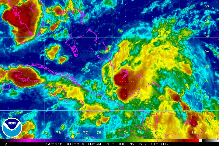
NHC drops percentages to 20/50%
TROPICAL WEATHER OUTLOOK
NWS NATIONAL HURRICANE CENTER MIAMI FL
800 PM EDT FRI AUG 26 2016
For the North Atlantic...Caribbean Sea and the Gulf of Mexico:
The National Hurricane Center is issuing advisories on Tropical
Storm Gaston, located about 1000 miles east-southeast of Bermuda.
1. Shower activity associated with a weak area of low pressure located
in the central Bahamas has increased during the past several hours
but it remains disorganized. Upper-level winds are not favorable
for significant development during the next day or so while the
system moves west-northwestward at about 10 mph. Environmental
conditions could become a little more conducive for some development
when the system reaches the eastern Gulf of Mexico early next week.
Heavy rains, with the potential to cause flash floods and mud
slides, are likely to continue over Hispaniola tonight and Saturday.
This activity is expected to spread over eastern and central Cuba
through the weekend. Gusty winds and locally heavy rainfall are
likely over portions of the Bahamas, and will spread into parts of
southern Florida and the Florida Keys over the weekend. Interests
elsewhere in Florida and the eastern Gulf of Mexico should continue
to monitor the progress of this disturbance.
* Formation chance through 48 hours...low...20 percent
* Formation chance through 5 days...medium...50 percent

 Page 1 of 1


Popular
Back to top