- My Forums
- Tiger Rant
- LSU Recruiting
- SEC Rant
- Saints Talk
- Pelicans Talk
- More Sports Board
- Fantasy Sports
- Golf Board
- Soccer Board
- O-T Lounge
- Tech Board
- Home/Garden Board
- Outdoor Board
- Health/Fitness Board
- Movie/TV Board
- Book Board
- Music Board
- Political Talk
- Money Talk
- Fark Board
- Gaming Board
- Travel Board
- Food/Drink Board
- Ticket Exchange
- TD Help Board
Customize My Forums- View All Forums
- Show Left Links
- Topic Sort Options
- Trending Topics
- Recent Topics
- Active Topics
Started By
Message
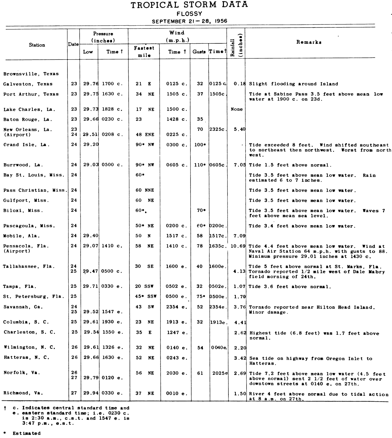
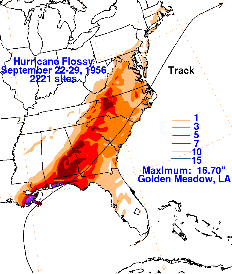
Hurricane Flossy - September 24, 1956 - SE LA coastal parishes, MS, AL coast, FL panhandle
Posted on 9/24/25 at 11:43 am
Posted on 9/24/25 at 11:43 am
Flossy may not have had the strongest winds, but she moved slowly and pushed a lot of water and dropped a ton of rain. Seems similar to Isaac from 2012. My grandmother used to always tell me about this one besides Betsy when we talked about hurricanes.
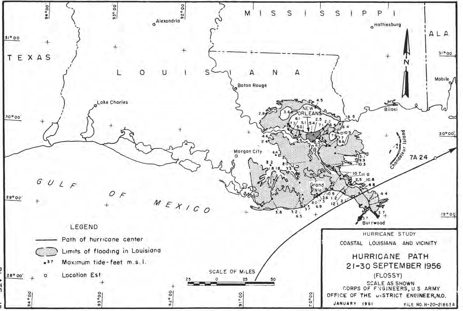
Landfalls: Mouth of Mississippi River just south of Venice, LA and Destin, FL
Maximum Sustained Winds: 90 mph
Minimum central pressure: 974 mb
Highest storm surge: ~12-13 feet at Ostrica Locks near Buras, LA, ~7 feet Laguna Beach, FL
Deaths: 15
 >
>
Landfalls: Mouth of Mississippi River just south of Venice, LA and Destin, FL
Maximum Sustained Winds: 90 mph
Minimum central pressure: 974 mb
Highest storm surge: ~12-13 feet at Ostrica Locks near Buras, LA, ~7 feet Laguna Beach, FL
Deaths: 15
> quote:
September 24:
Ship highlights:
65 kt SSW and 984 mb at 28.1N, 89.0W at 12Z
980 mb (“passed within the eye”) at 15Z, no location
974 mb (“a dredge within the eye”) at Destin at 2325Z
Land highlights:
72 kt, gusts to 82 kt at an Oil Rig at 29.1N, 90.5W at 0505Z
78 kt (estimated) NW, gusts to 85 kt, 989 mb at Grand Isle, LA at 09Z
983 mb at Burrwood, LA at 1010Z
983 mb at Venice, LA (calm between 0950Z-1155Z)
78 kt (estimated) NW at Burrwood, LA at 1228Z
984 mb with 50 kt NE (max wind) at Pensacola (airport), FL at 2010Z
980 mb with 30 kt N at Pensacola NAS at 2030Z, 56 kt max wind
Aircraft highlights:
Penetration center fix at 30.2N, 87.1W at 2142Z (ATSR). Penetration center fix measured a central pressure of 974 mb, maximum surface winds of 80 kt and an eye diameter of 30 nm at 30.3N, 86.9W at 2230Z (ATSR). Penetration center fix at 30.4N, 86.3W at 2330Z (ATSR). “29.2N, 89.6W – 974 mb – 1013 mb Penv – RMW 22 nmi – speed 10 kt – 70 kt est max sustained 10m, 10-min wind
973.9 mb central pressure measured by land barometer at Destin, FL and RECON – RMW 18 nmi – 10 kt forward speed – landfall pt 30.4N, 86.4W
“During the afternoon the hurricane turned rather sharply toward the eastnortheast, crossing the Mississippi delta a little north Burrwood near Pilottown early on the 24th. Here it seems to have reached maximum intensity with the highest wind at Burrwood 84 m.p.h and lowest pressure 29.03 inches. An oil rig a little west of Grande Isle reported a maximum wind of 83 m.p.h and gust to 95.
The center passed a little south of Pensacola, Florida, during the afternoon and later about over Fort Walton. The storm became extra-tropical shortly after the center passed out of Florida but it moved northeastward inside the coastlines as an energetic storm until it passed out to sea near the Virginia Capes. As far as known, no hurricane winds were reported at any Florida point although winds were near hurricane force eastward along the coast to Panama City.
The lowest pressure reported during the storm was 28.93 inches at the Pensacola Naval Air Station. The highest storm tide was 7.4 feet m.s.l at Laguna Beach, Florida. Some higher values were reported along the eastern side of the Mississippi delta but have not been verified. Tides flooded portions of Norfolk, Va., and water stood 2.5 feet deep in several of the principal street.”
“Flossy entered the Mississippi Delta 10 miles north of Burrwood, Louisiana, at 1100Z on the 24th and continued on the northeast course until passing into the Atlantic at Elizabeth City, North Carolina, on the 27th.” “... and continued increasing to a maximum of 105 knots while passing south of Mobile, Alabama, on the 24th. No sustained winds greater than 40 knots existed after Flossy passed Dothan, Alabama.”
“The central pressure early on the morning of the 24th, at the time the hurricane center crossed the Mississippi Delta, as computed to be near 28.80 in. [975 mb]...Radius of maximum winds – 22 nm”.
 6
6


Posted on 9/24/25 at 1:26 pm to NorthEndZone


Posted on 9/24/25 at 1:41 pm to NorthEndZone
Its crazy how back then storms could just hit with little to no warning. Now we have all these models, most of which are wrong when looking at the long range stuff but at least we have them to watch and see if there is something we need to keep an eye on for the next week or so.
That being said I wont post the GFS from noon today... but its good news for Louisiana. However we all know how unreliable the GFS is that far out.
That being said I wont post the GFS from noon today... but its good news for Louisiana. However we all know how unreliable the GFS is that far out.

Posted on 9/25/25 at 1:22 am to NorthEndZone
quote:
Hurricane Flossy
We're not a serious country.
Posted on 9/25/25 at 3:21 am to NorthEndZone

Posted on 9/25/25 at 3:51 am to NorthEndZone
Wasn’t it 1965, not 1956?
Posted on 9/25/25 at 7:19 am to covlatiger
quote:
Wasn’t it 1965, not 1956?
'65 was Betsy.
Flossie tickled LA's balls, then moved on. ]

This post was edited on 9/25/25 at 7:21 am

 Page 1 of 1


Popular
Back to top