- My Forums
- Tiger Rant
- LSU Recruiting
- SEC Rant
- Saints Talk
- Pelicans Talk
- More Sports Board
- Fantasy Sports
- Golf Board
- Soccer Board
- O-T Lounge
- Tech Board
- Home/Garden Board
- Outdoor Board
- Health/Fitness Board
- Movie/TV Board
- Book Board
- Music Board
- Political Talk
- Money Talk
- Fark Board
- Gaming Board
- Travel Board
- Food/Drink Board
- Ticket Exchange
- TD Help Board
Customize My Forums- View All Forums
- Show Left Links
- Topic Sort Options
- Trending Topics
- Recent Topics
- Active Topics
Started By
Message
re: Severe Weather Rolls On: May 7-10, 2024
Posted on 5/8/24 at 7:52 pm to LegendInMyMind
Posted on 5/8/24 at 7:52 pm to LegendInMyMind
Here ya go
 3
3


Posted on 5/8/24 at 7:54 pm to Pedro

Mesoscale Discussion 0717
NWS Storm Prediction Center Norman OK
0742 PM CDT Wed May 08 2024
Areas affected...northern Alabama...southern Middle and into eastern
Tennessee...northwestern Georgia...and far western North Carolina
Concerning...Tornado Watch 211...
Valid 090042Z - 090245Z
The severe weather threat for Tornado Watch 211 continues.
SUMMARY...Severe/tornado threat is increasing across Tornado Watch
211 -- from the Tennessee Valley into the southern Appalachians.
DISCUSSION...Latest radar loop across the region shows storms
increasing rapidly in coverage and intensity from northern Alabama
and southern Middle Tennessee, eastward to southeastern Tennessee
and northwestern Georgia. This appears to be occurring in response
to an increase in low-level warm advection, associated with a
gradually veering low-level jet. Meanwhile, strong storms --
including a long-lived supercell now moving into the Warren County
Tennessee vicinity -- are expected to continue moving eastward out
of WW 206 into Tornado Watch 211 in the next hour or so.
With this area on the eastern edge of a very moist/unstable airmass
across the lower Mississippi and Tennessee Valleys, and shear
favoring organized/rotating storms, severe/isolated tornado risk
should continue to increase in the short term, across this area.
..Goss.. 05/09/2024
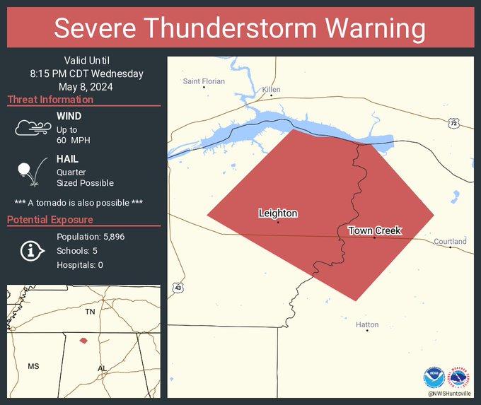
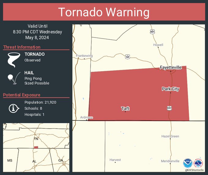
Posted on 5/8/24 at 7:55 pm to Roll Tide Ravens
Warnings going up all over the place.

Posted on 5/8/24 at 7:57 pm to Roll Tide Ravens
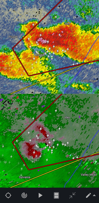
Anderson, AL is confirmed by spotters.
Posted on 5/8/24 at 7:58 pm to Roll Tide Ravens
Tornado on the ground near Elkton, TN in Giles County. Just across the AL/TN state line.
This post was edited on 5/8/24 at 7:59 pm

Posted on 5/8/24 at 7:59 pm to LegendInMyMind
IYKYK
Posted on 5/8/24 at 7:59 pm to SidewalkTiger
Just got out of church and a brief look at the radar those cells in Tennessee have a VERY BAD look to them

Posted on 5/8/24 at 7:59 pm to Roll Tide Ravens
Looks like a wild night is incoming. Y’all stay safe out there Bama and Tenner baws
Posted on 5/8/24 at 8:00 pm to Roll Tide Ravens
We’re in an outbreak now.
Posted on 5/8/24 at 8:00 pm to Bobby OG Johnson
quote:
Bobby OG Johnson
Dammit Bobby, that's why I like ya!
Posted on 5/8/24 at 8:00 pm to Bobby OG Johnson
Posted on 5/8/24 at 8:00 pm to Roll Tide Ravens
quote:
We’re in an outbreak now.
Oh yeah, getting hairy up here baws.
Posted on 5/8/24 at 8:01 pm to Roll Tide Ravens

Posted on 5/8/24 at 8:02 pm to Roll Tide Ravens
This is fricking bad
Posted on 5/8/24 at 8:05 pm to Roll Tide Ravens

This post was edited on 5/8/24 at 8:06 pm
Posted on 5/8/24 at 8:06 pm to Roll Tide Ravens
Circle the one below the southern one, too. It just went warned.
Posted on 5/8/24 at 8:06 pm to LegendInMyMind
quote:
Dammit Bobby, that's why I like ya!
We have a rich vibrant history that should be celebrated
I just wales out...
Posted on 5/8/24 at 8:08 pm to Bobby OG Johnson
Probably should have included N Alabama in this frame
Loading Twitter/X Embed...
If tweet fails to load, click here.
 Page 14 of 36

Popular
Back to top