- My Forums
- Tiger Rant
- LSU Recruiting
- SEC Rant
- Saints Talk
- Pelicans Talk
- More Sports Board
- Fantasy Sports
- Golf Board
- Soccer Board
- O-T Lounge
- Tech Board
- Home/Garden Board
- Outdoor Board
- Health/Fitness Board
- Movie/TV Board
- Book Board
- Music Board
- Political Talk
- Money Talk
- Fark Board
- Gaming Board
- Travel Board
- Food/Drink Board
- Ticket Exchange
- TD Help Board
Customize My Forums- View All Forums
- Show Left Links
- Topic Sort Options
- Trending Topics
- Recent Topics
- Active Topics
Started By
Message
re: Severe Weather Rolls On: May 7-10, 2024
Posted on 5/8/24 at 4:13 pm to LegendInMyMind
Posted on 5/8/24 at 4:13 pm to LegendInMyMind
quote:
Warned for baseballs
 1
1

Posted on 5/8/24 at 4:17 pm to SteelerBravesDawg
The north AL tornado watch just went out on the weather radio.
ETA:
ETA:
Loading Twitter/X Embed...
If tweet fails to load, click here.This post was edited on 5/8/24 at 4:18 pm

Posted on 5/8/24 at 4:21 pm to LegendInMyMind
Frick this. It’s summer. Statute of limitations has closed for the bs.

Posted on 5/8/24 at 4:22 pm to LegendInMyMind
The National Weather Service in Paducah has issued a
* Tornado Warning for...
Northwestern Pope County in southern Illinois...
Northeastern Johnson County in southern Illinois...
Southeastern Williamson County in southern Illinois...
Southwestern Saline County in southern Illinois...
* Until 445 PM CDT.
* At 417 PM CDT, a confirmed tornado was located over Creal Springs,
or 9 miles southeast of Marion, moving east at 30 mph.
HAZARD...Damaging tornado.
SOURCE...Weather spotters confirmed tornado.
IMPACT...Flying debris will be dangerous to those caught without
shelter. Mobile homes will be damaged or destroyed.
Damage to roofs, windows, and vehicles will occur. Tree
damage is likely.
* This tornadic thunderstorm will remain over mainly rural areas of
northwestern Pope, northeastern Johnson, southeastern Williamson
and southwestern Saline Counties, including the following
locations... Stonefort and New Burnside.
Posted on 5/8/24 at 4:22 pm to LegendInMyMind
Creal Springs, IL observed tornado.
quote:
The National Weather Service in Paducah has issued a
* Tornado Warning for... Northwestern Pope County in southern Illinois... Northeastern Johnson County in southern Illinois... Southeastern Williamson County in southern Illinois... Southwestern Saline County in southern Illinois...
* Until 445 PM CDT.
* At 417 PM CDT, a confirmed tornado was located over Creal Springs, or 9 miles southeast of Marion, moving east at 30 mph.
HAZARD...Damaging tornado.
SOURCE...Weather spotters confirmed tornado.
IMPACT...Flying debris will be dangerous to those caught without shelter. Mobile homes will be damaged or destroyed. Damage to roofs, windows, and vehicles will occur. Tree damage is likely.
* This tornadic thunderstorm will remain over mainly rural areas of northwestern Pope, northeastern Johnson, southeastern Williamson and southwestern Saline Counties, including the following locations... Stonefort and New Burnside.
Posted on 5/8/24 at 4:23 pm to LSUGrrrl
quote:
Frick this. It’s summer.
It is May.
Posted on 5/8/24 at 4:23 pm to LegendInMyMind
Kids only have a week of school left. It’s summer.
Everyone stay safe out there.
Everyone stay safe out there.
Posted on 5/8/24 at 4:25 pm to NorthEndZone
PDS now on the IL tornado
Severe Weather Statement
National Weather Service Paducah KY
423 PM CDT Wed May 8 2024
ILC059-165-082145-
/O.CON.KPAH.TO.W.0043.000000T0000Z-240508T2145Z/
Saline IL-Gallatin IL-
423 PM CDT Wed May 8 2024
...A TORNADO WARNING REMAINS IN EFFECT UNTIL 445 PM CDT FOR
SOUTHEASTERN SALINE AND SOUTHWESTERN GALLATIN COUNTIES...
At 422 PM CDT, a confirmed large and extremely dangerous tornado was
located south of Harrisburg, moving east at 35 mph.
This is a PARTICULARLY DANGEROUS SITUATION. TAKE COVER NOW!
HAZARD...Damaging tornado.
SOURCE...Radar confirmed tornado.
IMPACT...You are in a life-threatening situation. Flying debris may
be deadly to those caught without shelter. Mobile homes
will be destroyed. Considerable damage to homes,
businesses, and vehicles is likely and complete destruction
is possible.
The tornado will be near...
Equality around 430 PM CDT.
Other locations impacted by this tornadic thunderstorm include
Junction.
Posted on 5/8/24 at 4:31 pm to NorthEndZone
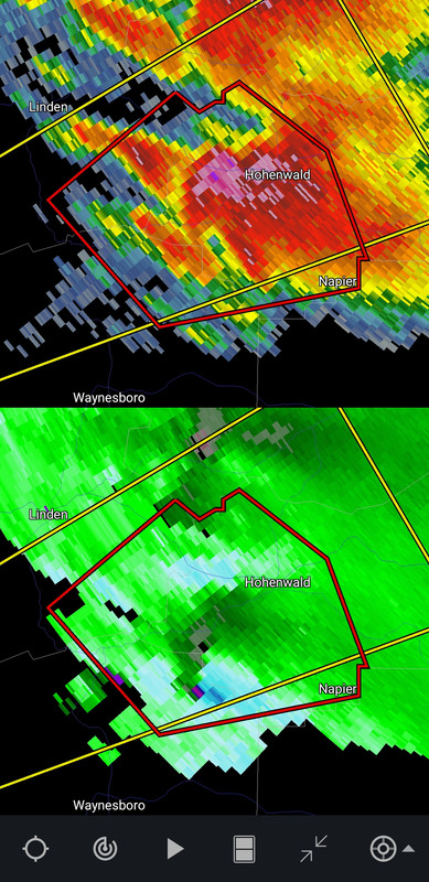
A lot of my favorite Tennessee towns are getting pelted with big hail today. Hohenwald is getting tennis balls currently.
Posted on 5/8/24 at 4:36 pm to LegendInMyMind
That's a dangerous storm, tornado or not.
Posted on 5/8/24 at 4:41 pm to NorthEndZone
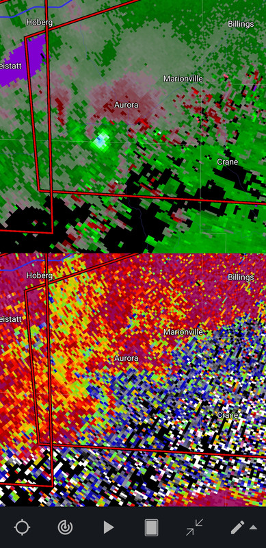
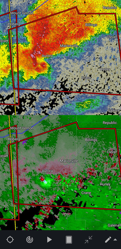
Verona / Aurora, MO confirmed
A TORNADO WARNING REMAINS IN EFFECT UNTIL 515 PM CDT FOR NORTHWESTERN CHRISTIAN...NORTHWESTERN STONE...NORTHEASTERN BARRY AND SOUTHEASTERN LAWRENCE COUNTIES...
At 436 PM CDT, a confirmed tornado was located over Verona, or near Aurora, moving east at 35 mph.
HAZARD...Damaging tornado and golf ball size hail.
SOURCE...Emergency management confirmed tornado.
IMPACT...Flying debris will be dangerous to those caught without shelter. Mobile homes will be damaged or destroyed. Damage to roofs, windows, and vehicles will occur. Tree damage is likely.
Locations impacted include... Aurora, Marionville, Clever, Crane, Billings, Verona, Hurley, Pleasant Ridge, and Madry.
Posted on 5/8/24 at 4:42 pm to LegendInMyMind
Confirmed SW or Springfield in the town of Aurora.
Posted on 5/8/24 at 4:44 pm to LegendInMyMind
Posted on 5/8/24 at 4:46 pm to LegendInMyMind
That one looks like it could impact NIxa and possibly southern Sprimgfield if it holds up.
ETA - Aurora may have taken a hit.
ETA - Aurora may have taken a hit.
quote:
444 PM CDT Wed May 8 2024
...A TORNADO WARNING REMAINS IN EFFECT UNTIL 515 PM CDT FOR
NORTHWESTERN CHRISTIAN...NORTHWESTERN STONE...NORTHEASTERN BARRY AND
SOUTHEASTERN LAWRENCE COUNTIES...
At 444 PM CDT, a confirmed large and extremely dangerous tornado was
located over Aurora, moving east at 30 mph.
This is a PARTICULARLY DANGEROUS SITUATION. TAKE COVER NOW!
HAZARD...Damaging tornado.
SOURCE...Emergency management confirmed tornado.
IMPACT...You are in a life-threatening situation. Flying debris may
be deadly to those caught without shelter. Mobile homes
will be destroyed. Considerable damage to homes,
businesses, and vehicles is likely and complete destruction
is possible.
Locations impacted include...
Aurora, Marionville, Clever, Crane, Billings, Verona, Hurley,
Pleasant Ridge, and Madry.
This post was edited on 5/8/24 at 4:49 pm
Posted on 5/8/24 at 4:47 pm to NorthEndZone
It spun down on the next frame. Hopefully it dies.
Posted on 5/8/24 at 4:50 pm to LegendInMyMind
What are yalls opinion on the severity of weather in Huntsville area?
Posted on 5/8/24 at 4:57 pm to TigerJack8
quote:
What are yalls opinion on the severity of weather in Huntsville area?
We could see some rough storms around 8-10 and then have to deal with the line and winds with hit around 3-5am.
Definitely have a way to get warnings that will wake you up.
This post was edited on 5/8/24 at 4:58 pm
Posted on 5/8/24 at 5:00 pm to LegendInMyMind
SW of Springfield, MO is now only radar indicated. Good news for now.

 Page 9 of 36

Popular
Back to top