- My Forums
- Tiger Rant
- LSU Recruiting
- SEC Rant
- Saints Talk
- Pelicans Talk
- More Sports Board
- Fantasy Sports
- Golf Board
- Soccer Board
- O-T Lounge
- Tech Board
- Home/Garden Board
- Outdoor Board
- Health/Fitness Board
- Movie/TV Board
- Book Board
- Music Board
- Political Talk
- Money Talk
- Fark Board
- Gaming Board
- Travel Board
- Food/Drink Board
- Ticket Exchange
- TD Help Board
Customize My Forums- View All Forums
- Show Left Links
- Topic Sort Options
- Trending Topics
- Recent Topics
- Active Topics
Started By
Message
re: Non-Political Mississippi River Question
Posted on 8/1/23 at 5:03 pm to BRich

Posted on 8/1/23 at 5:03 pm to BRich
quote:Interesting stuff. You seem very knowledgeable.
BRich
In the 19th century and before construction of those jetties in 1875, where did large merchant ships dock?
I am trying to get a feel for New Orleans river and ocean traffic during the period leading up to Texas independence and during the period of the Republic (say, 1821-1845 or so)
I have found old maps, but most do not show the docks. One from 1863 shows several large piers (maybe jetties?) jutting far out into the Pontchartrain, but none on the Mississippi itself.
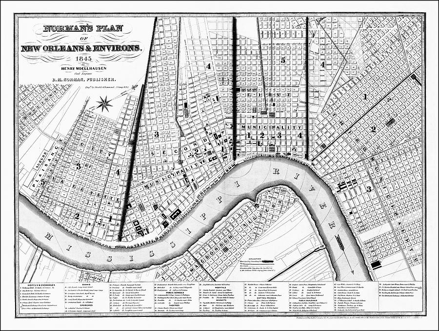
Another, from 1845, shows docks/quays along the entire length of the Left Bank, everywhere in the city. One continuous set of docks.
A map from 1723 shows no docks or quays or anything else at all along the river (but calls the Mississippi the "St.Louis Fleuve") nor does this one from 1795 (with palisade walls?):
This post was edited on 8/1/23 at 7:19 pm
 1
1

Posted on 8/1/23 at 5:19 pm to AggieHank86
Geography
Posted on 8/2/23 at 10:55 am to Y.A. Tittle
quote:
In the 18th century, when the city was founded (and for a number of years thereafter), merchant sailing vessels were coming into Lake Pontchartrain and up into Bayou St. John.
Quite true, as they did in the Carondelet (Old Basin) Canal and the New Basin Canal, both of which were dug well before the Industrial Canal (Carondelet in 1790s, New Basin in 1830s).
But while those boats were "merchant sailing vessels", they were NOT ocean-going sailing ships meant for international commerce. Look at the freeboard (side height from waterline) on the boat in your painting example, as well the ones in this early photograph of Bayou St. John:
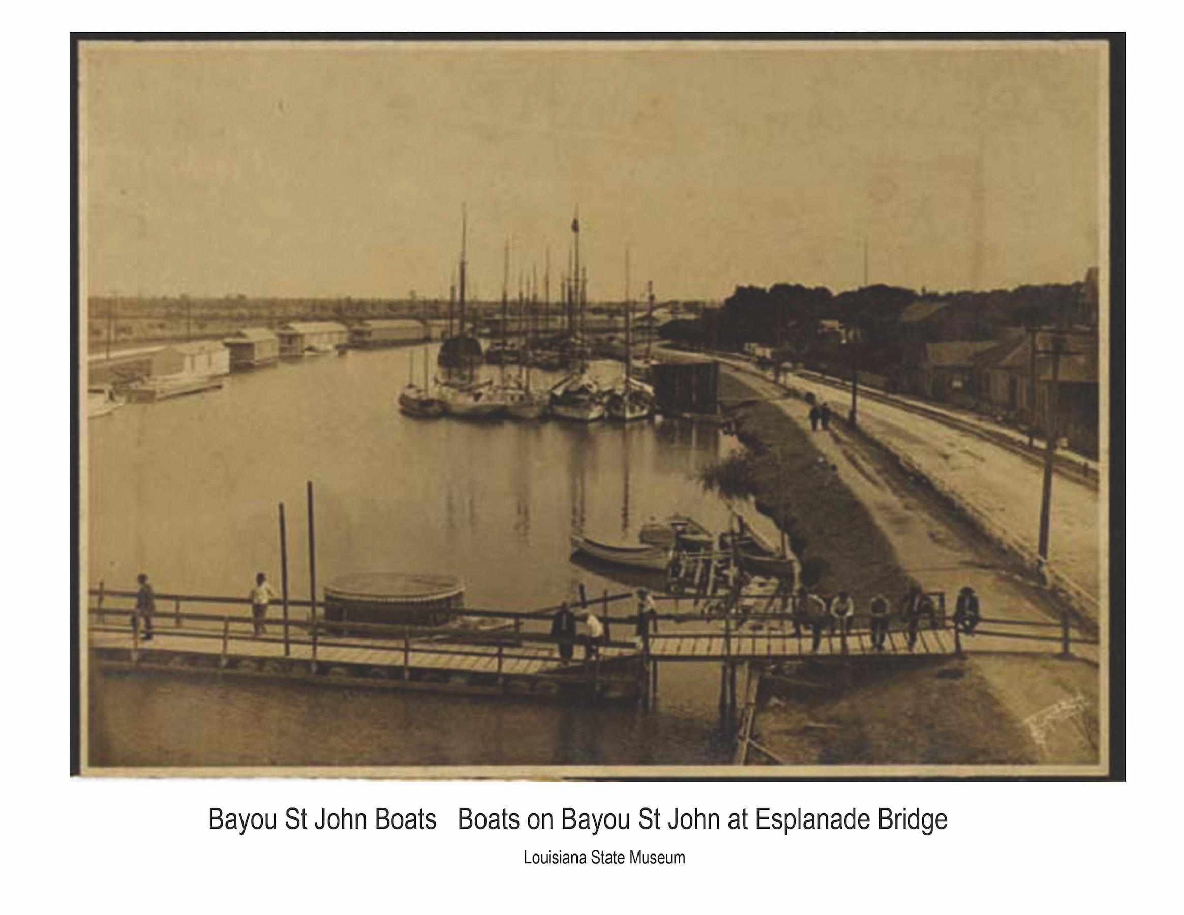 .
. Very low freeboard, showing these were for fishing and near-shore commerce.
Posted on 8/2/23 at 11:27 am to AggieHank86
quote:
Interesting stuff. You seem very knowledgeable.
Thank you.
quote:
In the 19th century and before construction of those jetties in 1875, where did large merchant ships dock?
I am trying to get a feel for New Orleans river and ocean traffic during the period leading up to Texas independence and during the period of the Republic (say, 1821-1845 or so)
I have found old maps, but most do not show the docks. One from 1863 shows several large piers (maybe jetties?) jutting far out into the Pontchartrain, but none on the Mississippi itself.
Another, from 1845, shows docks/quays along the entire length of the Left Bank, everywhere in the city. One continuous set of docks.
Re: the dockage along the river, it has essentially always been side or angle docking (or in the case of steamboats in the early days, sometimes head-in docking up to the riverbank) along the side of the Mississippi River, either with ramps in the old days or wharves such as there are today. Your 1845 drawing is probably most representative of this.
The following 1876 etching also gives a good idea of how this situation was handled. Ships (steamboats for interior commerce, large ocean-going ships for international commerce) are in the river and line the banks of the urbanized area.

Here is another etching from the Civil War era showing a similar situation:

Re: before the Eads jetties were constructed in 1875, where do merchant ships dock? The answer is, they docked at the same place, it was just that much more difficult to access. The mouths of the Mississippi were not entirely impassable prior to the jetties' construction, but access was certainly difficult. With increasing ship traffic and increasing size (and draft) of ships with the rise of steam power, that's what made a solution like the Eads jetties so vital.
Ships often had to wait for variations in tide and river levels to "cross the bar", and also relied on a Louisiana occupation that still exists today-- the use of river pilots who were familiar with the ever changing/shifting depths and channel locations in the lower river sections.
Mississippi River pilots still exist today (one lives across the street from me). On the lower Mississippi, there are actually three geographic areas for pilots. The Associated Branch Pilots supplies River Pilots between the Gulf of Mexico and Pilottown, Louisiana (where the river splits). The Crescent River Port Pilots Association supplies River Pilots between Pilottown and New Orleans, Louisiana, and the New Orleans-Baton Rouge Steamship Pilots Association supplies River Pilots between New Orleans and Baton Rouge, Louisiana.
These pilots make a LOT of money, by the way.
Finally, what you saw on Lake Pontchartrain were piers, not jetties. They would extend far out into the Lake because it was so shallow (unless a channel was cut).
This post was edited on 8/4/23 at 4:31 pm

 Page 5 of 5


Popular
Back to top