- My Forums
- Tiger Rant
- LSU Recruiting
- SEC Rant
- Saints Talk
- Pelicans Talk
- More Sports Board
- Fantasy Sports
- Golf Board
- Soccer Board
- O-T Lounge
- Tech Board
- Home/Garden Board
- Outdoor Board
- Health/Fitness Board
- Movie/TV Board
- Book Board
- Music Board
- Political Talk
- Money Talk
- Fark Board
- Gaming Board
- Travel Board
- Food/Drink Board
- Ticket Exchange
- TD Help Board
Customize My Forums- View All Forums
- Show Left Links
- Topic Sort Options
- Trending Topics
- Recent Topics
- Active Topics
Started By
Message
re: Miss River Flood Thread 2016, river back on the rise again.......
Posted on 1/7/16 at 8:28 pm to 1234567k
Posted on 1/7/16 at 8:28 pm to 1234567k
quote:
Where u get your info?
It is all over social media.
[link=(Corps to open Bonnet Carré Spillway Sunday https://www.wwltv.com/story/news/2016/01/07/corps-open-bonnet-carr-spillway-sunday/78438562/ (Sent from WWL TV))]WWL [/link]
 0
0

Posted on 1/7/16 at 8:29 pm to ScottieP
quote:
The Atch River was at 7.5 feet when they opened the Morganza spillway on May 14, 2011. They put 170,000cfs through Morganza and the river got to 10.3 ft.
It will not get that high unless a whole lot more rain happens up north.
This flood is not as bad as 2011, 1973, or 1927.
Calm down!!
Shut up, Junior, the adults are having a discussion.
LC
Posted on 1/7/16 at 8:32 pm to LongueCarabine
quote:
Shut up, Junior, the adults are having a discussion.
Could have fooled me.
Posted on 1/7/16 at 8:36 pm to ScottieP
quote:
Could have fooled me.
"Fool" is accurate.
LC
Posted on 1/7/16 at 8:43 pm to Fratigerguy
quote:
"the outside" as in the jack millers side of the levee? You won't see this water.
And you're in sorrel there, not pigeon.
You sound like you know what you're talking about until you try tell me where my camp is. I'm in Pigeon. I'm in the campground across the levee from the Pigeon landing. That's Pigeon 100%.
I find it hard to believe that this won't effect Grand River at all.
Does anyone else have info on how the lower grand will be effected and know what they are talking about?
This post was edited on 1/7/16 at 8:46 pm
Posted on 1/7/16 at 8:47 pm to ScottieP
I think you're very irresponsible with your statements. Modern man has never seen all 3 rivers this high this early. Your statements potentially put people in harms way.
This is not a dick measuring contest.
Some people post to help & get info/awareness out. Some people post to be condescending dicks.
How about getting with the program? Why don't you jump on the team and come on in for the big win?
This is not a dick measuring contest.
Some people post to help & get info/awareness out. Some people post to be condescending dicks.
How about getting with the program? Why don't you jump on the team and come on in for the big win?
Posted on 1/7/16 at 8:48 pm to shawnlsu
How would the water make it around the levee?
Posted on 1/7/16 at 8:53 pm to shawnlsu
I used to have a camp south of Berthlot's store by the bridge. The biggest problem we ever had with flooding was when the Spillway was really high in 83 and we got a lot of rain in the Grand river basin. The water really had nowhere to go once it got down around bell river/Lake Palourde. The spillway water really didn't effect the Pigeon area, but because of the back up down river, the rain caused flooding much quicker.
I guess the answer is that opening Morganza shouldn't directly effect lower grand river/bell river but if there is any significant rain event Grand RIver will have a much tougher time draining the rain.
hope that helps
Edit to add, If they were to open the Sorrel Locks and leave them open to relieve pressure on the spillway levees (not likely) then spillway water would flow directly into Grand River at Sorrel.
This post was edited on 1/7/16 at 8:58 pm
Posted on 1/7/16 at 8:54 pm to Ignignot
It won't but there are locks that connect that waterway to the Mississippi and the spillway. I'm just having a hard time believing that it will have zero effect, but if so great.
Posted on 1/7/16 at 8:56 pm to LSU2001
quote:
LSU2001
That's exactly the answer I was looking and hoping for. Thank you.
Posted on 1/7/16 at 9:00 pm to Voorhies7
quote:
How about getting with the program? Why don't you jump on the team and come on in for the big win?
Good luck with that. Apparently he's an engineer...

Posted on 1/7/16 at 9:01 pm to shawnlsu
quote:
You sound like you know what you're talking about until you try tell me where my camp is. I'm in Pigeon. I'm in the campground across the levee from the Pigeon landing. That's Pigeon 100%.
I find it hard to believe that this won't effect Grand River at all.
Does anyone else have info on how the lower grand will be effected and know what they are talking about?
Listen, dickbag. I was trying to help you. If you wanted to know about the LOWER grand river area, you possibly should have said that. Grand River is located across from Jack millers, goes to the levee, and crosses into the basin. But the point is still the same. The water will not back up from them opening Morganza. You can possibly have some back water slowing the outflow on a major rain event, but it won't back up. I've been down there since '85.
Posted on 1/7/16 at 9:03 pm to shawnlsu
If you ever see the locks open completely to drain either the river directly at Port Allen or the Sorrel locks open to drain the spillway, we have a much, much bigger problem than is currently forecast. That would be a last ditch, desperation effort to save population centers at the expense of the less populated west side. That would devastate plaquemine,pierre part, hell even Thibodaux would probably flood in that scenario
Posted on 1/7/16 at 9:14 pm to Fratigerguy
I "been down there" since 80 but factually you are correct about the flooding of the spillway effecting grand river. The rest is bullshite. Grand River is a local name and the waterway actually runs from the Port Allen Lock all the way to Lake Palourde in Morgan City. If you look on Google Earth, the name of the waterway is listed as Port Allen Lock and the area directly across from Jack Millers is Bayou Gross Tete.
Posted on 1/7/16 at 9:24 pm to LSU2001
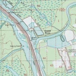
The area north of this is the port Allen lock area, along the levee. This is where grand river hits the levee, west of Jack millers. As you can see, it says grand river. I'm also well aware of where bayou grosse tete is.
Posted on 1/7/16 at 9:32 pm to Fratigerguy
What a condesinding POS you are. This thread is for information related to flooding. This isn't a place to show what an a-hole you can be by proving you know the difference between the "lower grand river area" and sorrel. Its all the same body of water.
LSU2001 I really appreciate your input on the LOWER GRAND RIVER AREA, lol. I'll sleep a little better tonight knowing that while it may get wet, my camp shouldn't flood due to this event.
LSU2001 I really appreciate your input on the LOWER GRAND RIVER AREA, lol. I'll sleep a little better tonight knowing that while it may get wet, my camp shouldn't flood due to this event.
This post was edited on 1/7/16 at 9:34 pm
Posted on 1/7/16 at 9:33 pm to Fratigerguy
mapThen google maps/earth has it mis-labled. I know we have always called the river Grand River from Jack millers all the way to Bell River. Regardless it's the same waterway
This post was edited on 1/7/16 at 9:37 pm
Posted on 1/7/16 at 9:50 pm to shawnlsu
quote:
What a condesinding POS you are. This thread is for information related to flooding. This isn't a place to show what an a-hole you can be by proving you know the difference between the "lower grand river area" and sorrel. Its all the same body of water.
Hey man. I was just trying to give you info. I wasn't being condescending in my original post. Being as you just moved a camp down there, I was trying to tell you that the grand river area (where the grand river landing is), is closer to sorrel than pigeon. You'd be surprised how many folks get the landings confused. You responded by telling me I didn't know what I was talking about. There are a number of camps, on grand river, right by the levee there that people have on state land. I thought you may have been in one of those, being as you said you were on grand river. That is all.
Posted on 1/7/16 at 9:57 pm to LSU2001
quote:
mapThen google maps/earth has it mis-labled. I know we have always called the river Grand River from Jack millers all the way to Bell River. Regardless it's the same waterway
Yeah they do. It defaults to the largest body of known water in the area, and then defaults to that no matter what you zoom in on until it gets to another known portion. Every canal and ditch is labeled port Allen lock when you zoom in.
No harm, I was really just trying to help the guy out. But you are correct in that it is irrelevant since it is all connected.
Posted on 1/7/16 at 9:57 pm to Fratigerguy
Will you two crybabies take this shite to the OT board.
We are grownups here
We are grownups here

 Page 20 of 35

Popular
Back to top