- My Forums
- Tiger Rant
- LSU Recruiting
- SEC Rant
- Saints Talk
- Pelicans Talk
- More Sports Board
- Fantasy Sports
- Golf Board
- Soccer Board
- O-T Lounge
- Tech Board
- Home/Garden Board
- Outdoor Board
- Health/Fitness Board
- Movie/TV Board
- Book Board
- Music Board
- Political Talk
- Money Talk
- Fark Board
- Gaming Board
- Travel Board
- Food/Drink Board
- Ticket Exchange
- TD Help Board
Customize My Forums- View All Forums
- Show Left Links
- Topic Sort Options
- Trending Topics
- Recent Topics
- Active Topics
Started By
Message
Elmer’s Island reopens March 5th with kayak launches and Shuttle Service
Posted on 3/1/21 at 12:24 pm

Posted on 3/1/21 at 12:24 pm
 5
5


Posted on 3/1/21 at 12:25 pm to lowhound
Driving on Elmers during the dune construction was always fun.
Posted on 3/1/21 at 12:28 pm to lowhound
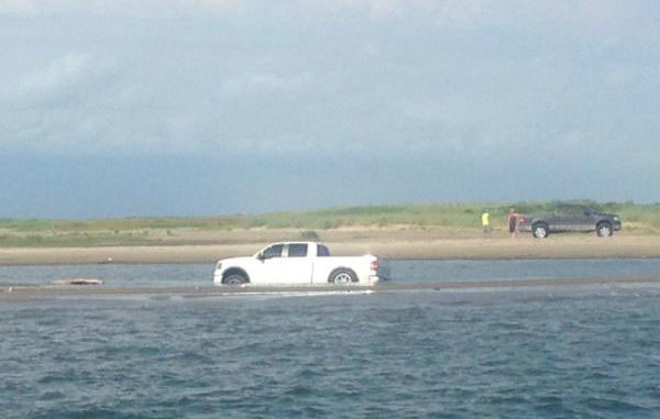
Where's the white F250?
Posted on 3/1/21 at 12:35 pm to LSUlefty
quote:
Where's the white F250?
That might be the new shuttle

Posted on 3/1/21 at 12:40 pm to jimbeam
Looking behind elmers and other estuaries, I always see thee lines where there is some kind of water boundary. Happens at the Pamlico sound all the time.
-can’t tell if it is wind or current created.
-does water depth have an effect on these?

-can’t tell if it is wind or current created.
-does water depth have an effect on these?
This post was edited on 3/1/21 at 12:43 pm
Posted on 3/1/21 at 12:50 pm to dstone12
tide lines, some really strong currents at the Caminada Pass
Posted on 3/1/21 at 12:53 pm to lowhound
Where is the shuttle going to bring you? Will the shuttle experience involve dirty diapers and all the other shite that the trashy mofos dump on the beach?
Posted on 3/1/21 at 1:58 pm to Wolfmanjack
I'm sure it won't be long before that system is scrapped due to trashy shite going on. If he starts running before daylight and drops you off at the point, I'm in. I wish there was a shuttle or ferry to get to Fourchon Beach instead actually.
This post was edited on 3/1/21 at 1:59 pm

Posted on 3/1/21 at 3:30 pm to LSUlefty
quote:Probably stuck in the surf
Where's the white F250?


Posted on 3/1/21 at 8:22 pm to dstone12
quote:
I always see thee lines where there is some kind of water boundary.
Way back in the 90's we used to surf fish as far as you could drive west on the beach in Cameron towards Sabine Pass. We could see Sabine Pass when we fished. We had Jeeps or 4-Runners for the journey. No white F-250's.
There were several old beach heads in the surf going out. You could see the breakers and we would wade out to them. Depending on the tide you almost had to swim across the ones further out. At the breakers the water was 2-3 foot deep and we could fish the next trough.
Good times and caught TONS of trout, and a few small sharks, when the water was right.
Have not been in years but that is what I think those are.
Same as Chenier's. Grand Chenier, Little Chenier and Chenier Perdue. Those are all old beach heads from many hundreds or thousands of years ago when Global Warming may have actually a thing.

Posted on 3/2/21 at 9:57 am to lowhound
The road was already a wreck before the hurricane.
This is welcomed news. We have a spot where we wreck em there.
This is welcomed news. We have a spot where we wreck em there.

 Page 1 of 1


Popular
Back to top