- My Forums
- Tiger Rant
- LSU Recruiting
- SEC Rant
- Saints Talk
- Pelicans Talk
- More Sports Board
- Fantasy Sports
- Golf Board
- Soccer Board
- O-T Lounge
- Tech Board
- Home/Garden Board
- Outdoor Board
- Health/Fitness Board
- Movie/TV Board
- Book Board
- Music Board
- Political Talk
- Money Talk
- Fark Board
- Gaming Board
- Travel Board
- Food/Drink Board
- Ticket Exchange
- TD Help Board
Customize My Forums- View All Forums
- Show Left Links
- Topic Sort Options
- Trending Topics
- Recent Topics
- Active Topics
Started By
Message
re: Tropical Storm Erika - fat lady has sung, passed out, & getting dry humped
Posted on 8/25/15 at 3:48 pm to baytiger
Posted on 8/25/15 at 3:48 pm to baytiger
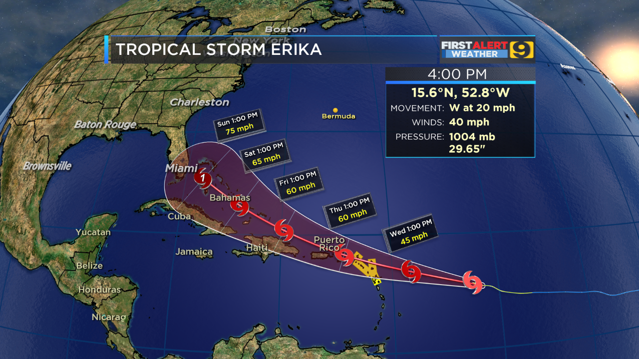
new advisory is out
quote:
SUMMARY OF 500 PM AST...2100 UTC...INFORMATION
----------------------------------------------
LOCATION...15.6N 52.8W
ABOUT 605 MI...975 KM E OF ANTIGUA
MAXIMUM SUSTAINED WINDS...40 MPH...65 KM/H
PRESENT MOVEMENT...W OR 280 DEGREES AT 20 MPH...31 KM/H
MINIMUM CENTRAL PRESSURE...1004 MB...29.65 INCHES
 1
1


Posted on 8/25/15 at 3:50 pm to rt3
WGAF it wont make the gulf, next year please...this year was a bust
Posted on 8/25/15 at 3:52 pm to musick
and the new 5 day track

Posted on 8/25/15 at 3:56 pm to musick
quote:not so fast there,jay grimes...still plenty of time and warm water out there.
WGAF it wont make the gulf, next year please...this year was a bust

Posted on 8/25/15 at 3:58 pm to TDsngumbo
So is this Erika what used to be Danny? Is this a zombiecane?

Posted on 8/25/15 at 4:04 pm to musick
quote:
WGAF it wont make the gulf, next year please...this year was a bust
You obviously haven't been paying attention to the forecasts and models on this storm...
The models have been shifting south and west since late last night. The high pressure system in the Atlantic is obviously pushing it further and further west. The Gulf coast is still not totally out of the woods. If I were in south Florida, especially southeastern Florida, I'd begin preparing for what will possibly be a very major hurricane next week. The official forecast still has it as a category 1 by that time but models are beginning to hint at this thing blowing up to a category 3 or 4.

This post was edited on 8/25/15 at 4:10 pm
Posted on 8/25/15 at 4:05 pm to TDsngumbo
Don't like that green one.
Posted on 8/25/15 at 4:07 pm to TDsngumbo
quote:What's the difference?
If I were in south Florida, especially southern Florida
Posted on 8/25/15 at 4:07 pm to Jim Rockford
quote:
Don't like that green one.
This will be one of those storms where the cone swings back and forth
Posted on 8/25/15 at 4:07 pm to Jim Rockford
quote:
Don't like that green one.
I'm looking at the 2 greens and the yellow as the transition of Katrina the Thursday & Friday before landfall
it was going to be a FL Panhandle storm... then that Friday evening... bam... it's our storm

Posted on 8/25/15 at 4:08 pm to Jim Rockford
quote:keep in mind that all of the gulf tracks have the storm weakening significantly... mostly to an open wave.. before entering the gulf. This isn't going to be a major hurricane if/when it gets there.
Don't like that green one.
Posted on 8/25/15 at 4:08 pm to Jim Rockford
quote:
Don't like that green one.
That green one does look ominous but keep in mind it's important to look more at the cluster of models and not one particular one. The general idea is that it's becoming more possible (not likely) that this will end up in the Gulf at some point. Once it's in the Gulf, it will have no choice but to eventually turn northward. Big question is where it will be when it turns northward.
In fact, that's the big question no matter what. Will it turn northward into the Carolinas, before that line of longitude and curve out to sea, or will it continue west-northwestward into the Gulf and THEN turn northward? We just have to keep an eye on it and see. Nobody knows at this point.
Posted on 8/25/15 at 4:08 pm to baytiger
quote:
keep in mind that all of the gulf tracks have the storm weakening significantly... mostly to an open wave.. before entering the gulf. This isn't going to be a major hurricane if/when it gets there.
Correct.
Posted on 8/25/15 at 4:08 pm to The Sad Banana
quote:
What's the difference?
I'm assuming he meant "if I were in the Florida peninsula, esp. southern FL"
Posted on 8/25/15 at 4:09 pm to TDsngumbo
quote:
The models have been shifting south and west since late last night. The high pressure system in the Atlantic is obviously pushing it further and further west
The ridge seems about on track for what models have been indicating but the system has stayed weak allowing it to be caught up in the low level flow.
Posted on 8/25/15 at 4:10 pm to The Sad Banana
quote:
If I were in south Florida, especially southern Florida
What's the difference?
Posted on 8/25/15 at 4:11 pm to TDsngumbo
quote:
Will it turn northward into the Carolinas
you've yet to give any reason why you think it's a threat to the Carolinas other than (poor) extrapolation from the very end of an already way-too-far-out model run. Even the graphic you just posted has only one noodle from an ensemble member that puts it into the Carolinas from open water
Posted on 8/25/15 at 4:11 pm to TDsngumbo
quote:
The official forecast still has it as a category 1 by that time but models are beginning to hint at this thing blowing up to a category 3 or 4.
Come on now... That is just a bridge too far.
Posted on 8/25/15 at 4:12 pm to rds dc
quote:
Come on now... That is just a bridge too far.
I'm just going by this:

Posted on 8/25/15 at 4:13 pm to TDsngumbo
quote:no you're going by your persistent habit of sensationalizing everything
I'm just going by this:

 Page 6 of 25

Popular
Back to top