- My Forums
- Tiger Rant
- LSU Recruiting
- SEC Rant
- Saints Talk
- Pelicans Talk
- More Sports Board
- Coaching Changes
- Fantasy Sports
- Golf Board
- Soccer Board
- O-T Lounge
- Tech Board
- Home/Garden Board
- Outdoor Board
- Health/Fitness Board
- Movie/TV Board
- Book Board
- Music Board
- Political Talk
- Money Talk
- Fark Board
- Gaming Board
- Travel Board
- Food/Drink Board
- Ticket Exchange
- TD Help Board
Customize My Forums- View All Forums
- Show Left Links
- Topic Sort Options
- Trending Topics
- Recent Topics
- Active Topics
Started By
Message
re: Tornado outbreak, 94 dead, Upwards of 100 unaccounted for search/rescue & cleanup ongoing
Posted on 12/10/21 at 5:49 pm to gaetti15
Posted on 12/10/21 at 5:49 pm to gaetti15
quote:
those are rookie numbers. We had a windchill of -50 a couple weeks back
Awfully brave to have a dick measuring contest in those temps, baw.
 2
2

Posted on 12/10/21 at 5:50 pm to Pisco
The storm SW of Jonesboro, AR is getting its act together.

Posted on 12/10/21 at 5:50 pm to LegendInMyMind
Severe Weather Statement
National Weather Service Paducah KY
543 PM CST Fri Dec 10 2021
KYC035-083-157-110015-
/O.CON.KPAH.TO.W.0029.000000T0000Z-211211T0015Z/
Calloway KY-Marshall KY-Graves KY-
543 PM CST Fri Dec 10 2021
...A TORNADO WARNING REMAINS IN EFFECT UNTIL 615 PM CST FOR
NORTHWESTERN CALLOWAY...MARSHALL AND EAST CENTRAL GRAVES COUNTIES...
At 542 PM CST, a severe thunderstorm capable of producing a tornado
was located near Sedalia, or 9 miles southeast of Mayfield, moving
northeast at 40 mph.
HAZARD...Tornado and quarter size hail.
SOURCE...Radar indicated rotation.
IMPACT...Flying debris will be dangerous to those caught without
shelter. Mobile homes will be damaged or destroyed. Damage
to roofs, windows, and vehicles will occur. Tree damage is
likely.
Locations impacted include...
Benton.
This includes Interstate 69 in Kentucky between Mile Markers 32 and
49.
PRECAUTIONARY/PREPAREDNESS ACTIONS...
TAKE COVER NOW! Move to a basement or an interior room on the lowest
floor of a sturdy building. Avoid windows. If you are outdoors, in a
mobile home, or in a vehicle, move to the closest substantial shelter
and protect yourself from flying debris.
Tornadoes are extremely difficult to see and confirm at night. Do not
wait to see or hear the tornado. TAKE COVER NOW!
&&
LAT...LON 3702 8829 3694 8819 3675 8811 3656 8852
3659 8855 3665 8859 3670 8861
TIME...MOT...LOC 2342Z 229DEG 36KT 3664 8851
TORNADO...RADAR INDICATED
MAX HAIL SIZE...1.00 IN
$$
SP
Posted on 12/10/21 at 5:50 pm to Pisco
quote:
This storm in Graves is really close to my Dad’s house, just S of Farmington.
It has tightened up, but hasn't shown a huge CC drop yet.

Posted on 12/10/21 at 5:51 pm to WhoDatBammer
quote:
The storm SW of Jonesboro, AR is getting its act together.
Damn it

Posted on 12/10/21 at 5:57 pm to WhoDatBammer
quote:
The storm SW of Jonesboro, AR is getting its act together.
Potential tornado in white county
Posted on 12/10/21 at 6:00 pm to pioneerbasketball
I didn't know there was a Tupelo, Arkansas.
Posted on 12/10/21 at 6:03 pm to pioneerbasketball
quote:
Potential tornado in white county
racist
Posted on 12/10/21 at 6:04 pm to rt3
Theres a white river and black river nearby.
Posted on 12/10/21 at 6:05 pm to Pisco
quote:
Pisco
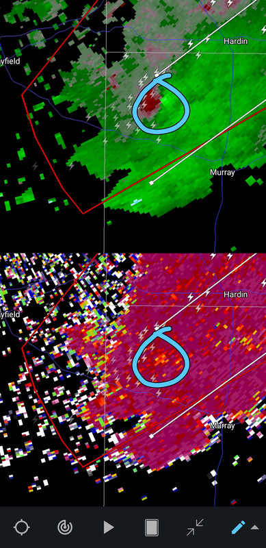
How big of a town is Hardin?
Posted on 12/10/21 at 6:05 pm to pioneerbasketball
quote:
Theres a white river and black river nearby.
clearly segregated from each other
Posted on 12/10/21 at 6:06 pm to LegendInMyMind
quote:
Awfully brave to have a dick measuring contest in those temps, baw.
can't happen, nobody would be able to measure anything
Posted on 12/10/21 at 6:07 pm to gaetti15
quote:
can't happen, nobody would be able to measure anything
So a normal spring day for some of us
Not me, totally not me, just some of us….
Posted on 12/10/21 at 6:08 pm to LegendInMyMind
quote:
How big of a town is Hardin?
Not big at all. A small town between Benton and Murray. It’s near Land Between the Lakes and they used to have a couple popular bait shops for fishermen there. I think it’s become a bit of a drug town now.
Posted on 12/10/21 at 6:08 pm to LegendInMyMind
Duke, what do you make of this, debris?
Posted on 12/10/21 at 6:09 pm to LegendInMyMind
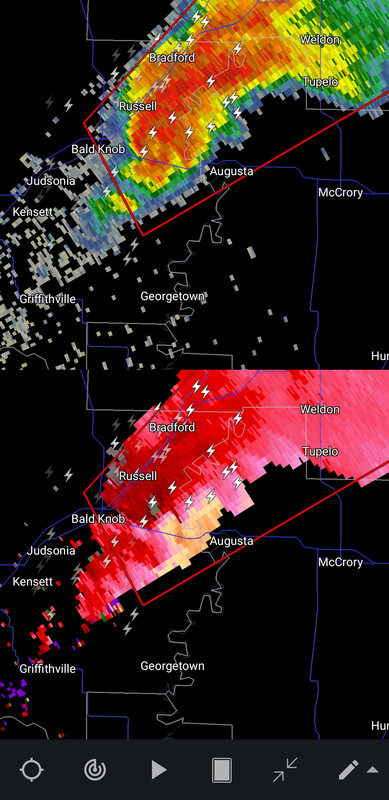
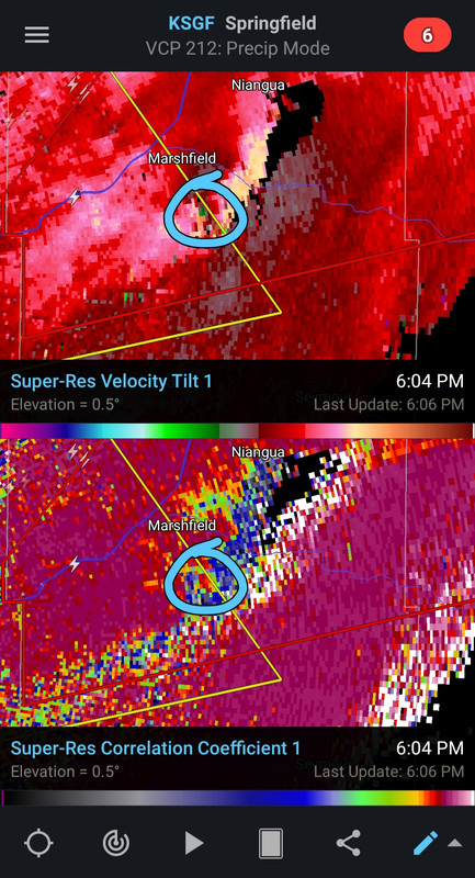
Tornado warning for sw Jonesboro.
Posted on 12/10/21 at 6:09 pm to LegendInMyMind
KAIT 8 for the Arkansas livestream
Posted on 12/10/21 at 6:11 pm to Pisco
What I watch for local news when I do watch local.

 Page 9 of 90

Popular
Back to top