- My Forums
- Tiger Rant
- LSU Recruiting
- SEC Rant
- Saints Talk
- Pelicans Talk
- More Sports Board
- Coaching Changes
- Fantasy Sports
- Golf Board
- Soccer Board
- O-T Lounge
- Tech Board
- Home/Garden Board
- Outdoor Board
- Health/Fitness Board
- Movie/TV Board
- Book Board
- Music Board
- Political Talk
- Money Talk
- Fark Board
- Gaming Board
- Travel Board
- Food/Drink Board
- Ticket Exchange
- TD Help Board
Customize My Forums- View All Forums
- Show Left Links
- Topic Sort Options
- Trending Topics
- Recent Topics
- Active Topics
Started By
Message
 2
2

Posted on 12/11/21 at 11:56 am to DomincDecoco
quote:
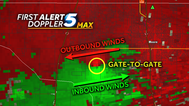
Could, you, Duke, or one of the other weather guys explain "gate to gate" velocity?
Think of a "gate" as a pixel on a radar when you are looking at it in Velocity mode.
When you see a couplet that correctly indicates rotation, two of those pixels will touch. One will be winds inbound to the radar, the other will be winds outbound to the radar.
Using a radar analysis tool you can analyze each individual pixel and see what wind speed it represents. So, you measure both the inbound and outbound pixels that are touching and add them together. The result is the total amount of gate-to-gate shear or the strength of the velocity couplet.
That measurement still, however, will not give you ground truth. It is still a measurement taken possibly thousands of feet off the ground and miles away from the radar.
It takes a NWS survey to determine how that measurement translates to the tornado at ground level.
Posted on 12/11/21 at 11:57 am to East Coast Band
quote:
Everyone news wise is here. Storm chasers, Weather Channel, Fox News.
You know things are fricked up when you have the President and Governor in town looking at damage, NBC News doing their evening news on a street corner, Jim Cantore doing a live shot every few minutes for days, helicopters flying overhead like it is some bad war movie, and a bunch of out of town assholes with media credentials asking you what you think about the place you live getting wiped out. After April 27, 2011 I'd never wish that on anyone.
My heart aches for anyone who is dealing with the aftermath of this or any natural disaster.
Posted on 12/11/21 at 11:57 am to DomincDecoco
quote:
Could, you, Duke, or one of the other weather guys explain "gate to gate" velocity?
They were goin bonkers over >300mph speed.
basically it's simple addition... what the radar say the outbound winds are plus what the inbound winds are = gate to gate shear
if a radar says it's 100 mph outbound and 100mph inbound... it's 200 mph gate-to-gate... or the potential for a 200 mph tornado where outbound and inbound winds meet
This post was edited on 12/11/21 at 11:58 am

Posted on 12/11/21 at 11:57 am to RollTide1987
It’s so scary when it’s pitch black and then the lightning lights up a monster like that. I can’t fathom what that feels like IRL. Nuts.
Posted on 12/11/21 at 11:58 am to rt3
My brother in-law and his family are in Bowling Green. They’re okay but their neighborhood was very very close to being hit. Cotton BBQ is setting up in the parking lot of Rian’s Fatted Calf to give free meals to anyone in need. Address is below:
quote:
1104 Broadway Ave, Bowling Green, KY 42104, United States
Posted on 12/11/21 at 12:02 pm to When in Rome
quote:
It’s so scary when it’s pitch black and then the lightning lights up a monster like that. I can’t fathom what that feels like IRL. Nuts.
And there is no apparently movement right to left in the video at first. Looks like it’s coming right for the camera for a while.
Posted on 12/11/21 at 12:05 pm to Duke
Ok yea that is true.

Posted on 12/11/21 at 12:13 pm to rt3
Thanks to you and Legend.
So literally, the gate to gate indicated a 150mph tornado, which seems low for that type of damage.
When it's evaluated by NWS, you think they'll adjust the wind speed?
So literally, the gate to gate indicated a 150mph tornado, which seems low for that type of damage.
When it's evaluated by NWS, you think they'll adjust the wind speed?
Posted on 12/11/21 at 12:20 pm to Duke
quote:
They'll probably have to use radar data to find when it really peaked. It could have been at its most violent somewhere very rural and only get an EF3 there, because rating is based on damage.
So the radar data will tell a better story than on the ground surveys either.
I was listening to a podcast interview with Tim Marshall the other day. Part of it was talking about the ongoing efforts to upgrade the EF Scale. I took away that they eventually want to include radar data, but it will be years before that happens.
It often gets lost in the ratings debates that the F Scale and the later EF Scale are, by definition, damage ratings. All that matters to a NWS survey crew is what they see on the ground. The rest is up for debate on WxTwitter daily.
Posted on 12/11/21 at 12:22 pm to DomincDecoco
quote:
So literally, the gate to gate indicated a 150mph tornado, which seems low for that type of damage.
It depends on which pixels you cherry pick. This same debate has been going on about the El Reno EF3(5*).
Posted on 12/11/21 at 12:23 pm to DomincDecoco
quote:
When it's evaluated by NWS, you think they'll adjust the wind speed?
The NWS will rate the tornado, and every tornado, on the damage they see on the ground. Radar data will not factor in at all.
Posted on 12/11/21 at 12:34 pm to LegendInMyMind
quote:
Using a radar analysis tool you can analyze each individual pixel and see what wind speed it represents. So, you measure both the inbound and outbound pixels that are touching and add them together. The result is the total amount of gate-to-gate shear or the strength of the velocity couplet.
I want to add that Nelson Tucker's Tweet (posted here also) last night that showed the ~283mph g-t-g shear may have been a product of radar dealiasing, or a glitch if you will.
I tend to agree that that particular measurement wasn't accurate. However, it doesn't matter. A cleaner reading a few frames later showed 299mph g-t-g.
Time, debate, and exhaustive analysis will determine the final statistics of this monster storm.
Posted on 12/11/21 at 12:46 pm to LegendInMyMind
quote:
It depends on which pixels you cherry pick. This same debate has been going on about the El Reno EF3(5*).
Between that, the F vs EF scale and there currently being no rating higher than a 5 (sound familiar?)...the study of meteorology has some work to do.
Posted on 12/11/21 at 12:49 pm to LegendInMyMind
quote:
The NWS will rate the tornado, and every tornado, on the damage they see on the ground. Radar data will not factor in at all.
Thinking about the differences between a tornado going over a freshly plowed field, or hard packed Mississippi clay, it just doesn't see like apples to apples.
Posted on 12/11/21 at 12:52 pm to DomincDecoco
you could say last night's top storm 1st started getting "that look" just north of Little Rock, Ark.
Posted on 12/11/21 at 12:58 pm to RockChalkTiger
quote:
What is unprecedented is the increasing frequency and severity. What are the Gulf SSTs right now? Where did that beast last night get all its energy? Welcome to the new normal.
Oh FFS it is not a new normal. Weather patterns are cyclical and it was known months ago the southeast would have above average temps this winter due to weather patterns. Thus warmer gulf moisture and more opportunity for severe weather.
Posted on 12/11/21 at 1:09 pm to deltaland
Just heard a prelim rating of EF3 in Monette. Naturally, the NWS said that could change.
Posted on 12/11/21 at 1:14 pm to DomincDecoco
quote:
Between that, the F vs EF scale and there currently being no rating higher than a 5 (sound familiar?)...the study of meteorology has some work to do.
At a certain point with high end violent tornadoes, it just becomes a process of splitting hairs. If you hit 200mph in a tornado, anything over that doesn't really matter. Call one of those tornadoes whatever you want, it will always boil down to death and destruction.
The gains to be made are in engineering and affordable/accessible shelter, because with these type storms anywhere above ground that isn't a safe room will always be a risk.

Posted on 12/11/21 at 1:19 pm to LegendInMyMind
Got a friend in Bremen, Kentucky who lost their infant nephew when Tornado hit their house. Both parents in hospital but expected to survive.
I cant imagine their pain, go hug your kids folks...
I cant imagine their pain, go hug your kids folks...

 Page 66 of 90

Popular
Back to top