- My Forums
- Tiger Rant
- LSU Recruiting
- SEC Rant
- Saints Talk
- Pelicans Talk
- More Sports Board
- Fantasy Sports
- Golf Board
- Soccer Board
- O-T Lounge
- Tech Board
- Home/Garden Board
- Outdoor Board
- Health/Fitness Board
- Movie/TV Board
- Book Board
- Music Board
- Political Talk
- Money Talk
- Fark Board
- Gaming Board
- Travel Board
- Food/Drink Board
- Ticket Exchange
- TD Help Board
Customize My Forums- View All Forums
- Show Left Links
- Topic Sort Options
- Trending Topics
- Recent Topics
- Active Topics
Started By
Message
re: Severe Weather: March 15-16, 2026
Posted on 3/15/26 at 10:54 pm to Wishnitwas1998
Posted on 3/15/26 at 10:54 pm to Wishnitwas1998
I think it is wind reports from the reporting system that people can add to.
This post was edited on 3/15/26 at 10:55 pm
 2
2

Posted on 3/15/26 at 10:58 pm to LegendInMyMind
And we have an example. The merger has really ramped that rotation back up.
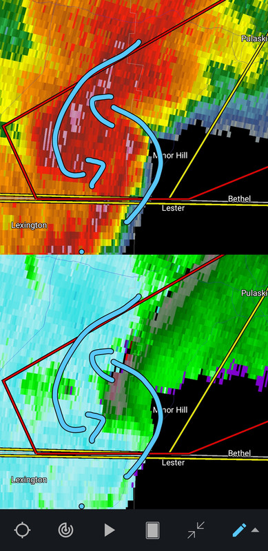
Between Minor Hill and Loretto, TN.
Between Minor Hill and Loretto, TN.
This post was edited on 3/15/26 at 11:00 pm
Posted on 3/15/26 at 11:00 pm to LegendInMyMind
You can see the rotation on Reflectivity. That is a dangerous storm right now.
This post was edited on 3/15/26 at 11:01 pm
Posted on 3/15/26 at 11:01 pm to LegendInMyMind
I’ve read conflicting reports for Birmingham all day. Some say we’re right in the target zone for 70+ mph winds with potential for tornadoes. The current AWS forecast says wind gusts up to 40 mph. I read earlier that the storms would weaken in the mid part of Alabama before increasing chances for tornados in Southeast Alabama. But the orange warning area extended to include Birmingham.
Any thoughts on what we’re about to experience?
Any thoughts on what we’re about to experience?
Posted on 3/15/26 at 11:02 pm to LegendInMyMind
This post was edited on 3/15/26 at 11:02 pm
Posted on 3/15/26 at 11:03 pm to StringedInstruments
quote:
Any thoughts on what we’re about to experience?
I think most everyone in the state will be under at least a Severe Thunderstorm Warning at some point as this moves through.

Posted on 3/15/26 at 11:10 pm to LegendInMyMind
Sirens going off here. Radar indicated tornado just south of us in Fern Creek (Jefferson)/Mt Washington (Bullitt County).
Posted on 3/15/26 at 11:12 pm to BluegrassBelle
quote:
Sirens going off here. Radar indicated tornado just south of us in Fern Creek (Jefferson)/Mt Washington (Bullitt County).
That's a nasty bowing line with lots of embedded rotations.

Posted on 3/15/26 at 11:15 pm to LegendInMyMind
Which app is that?
Posted on 3/15/26 at 11:15 pm to Dr Lecter
quote:
Which app is that?
Radar Scope. It may look a little different because it is an older version. I haven't updated it in a while.

Posted on 3/15/26 at 11:35 pm to LegendInMyMind
Just drove from Monroe to Marksville. From about Grayson to around Deville that was some insane weather. Heavy arse rain, wind, hail, a big arse tree down on LA 28 by T-Towne. And the temp dropped about 25 degrees in 10 minutes.
Posted on 3/15/26 at 11:38 pm to LegendInMyMind
Sirens just stopped. Got pretty windy, looks like some small branches down in the yard. Moved through pretty quick. Tornado Watch just expired as well.
Good luck folks. I’m headed to bed.
Good luck folks. I’m headed to bed.

Posted on 3/15/26 at 11:58 pm to BluegrassBelle
Sitting at the Love's truck stop in Vicksburg MS for the night - was about 15 minutes of heavy rain and some wind and it's over. tbh the wind earlier this afternoon coming from Waco TX to here was worse than that storm. G'night again!
Posted on 3/16/26 at 12:03 am to Horsemeat
Well, it is just about here. Wind and lightning picking up. Wind shift to the SSW.
Posted on 3/16/26 at 12:16 am to LegendInMyMind
Getting light shows in the Zachary/Port Hudson area.
Posted on 3/16/26 at 12:22 am to NOLA1128
We had some small hail and wind gusting to 50-55mph. Almost out of the worst of it.
ETA: Temp has dropped ~15 degrees in less than 20 minutes.
ETA: Temp has dropped ~15 degrees in less than 20 minutes.
This post was edited on 3/16/26 at 12:25 am
Posted on 3/16/26 at 12:29 am to LegendInMyMind
There was a tornado that did damage from the NW AL storm around the state line up to where it was on the screen cap I posted earlier. Structure damage, no reported injuries.
Posted on 3/16/26 at 12:43 am to LegendInMyMind
We have ducks!!!
(Makes sense if watching Spann's feed)
(Makes sense if watching Spann's feed)
Posted on 3/16/26 at 12:44 am to Wishnitwas1998
Yeah, I saw the duck. It is chilling in a puddle now amidst the debris.
Posted on 3/16/26 at 12:48 am to LegendInMyMind
Yea I have a feeling the duck may be pleased with the new renovations assuming the puddles hang around 

 Page 8 of 10

Popular
Back to top