- My Forums
- Tiger Rant
- LSU Recruiting
- SEC Rant
- Saints Talk
- Pelicans Talk
- More Sports Board
- Fantasy Sports
- Golf Board
- Soccer Board
- O-T Lounge
- Tech Board
- Home/Garden Board
- Outdoor Board
- Health/Fitness Board
- Movie/TV Board
- Book Board
- Music Board
- Political Talk
- Money Talk
- Fark Board
- Gaming Board
- Travel Board
- Food/Drink Board
- Ticket Exchange
- TD Help Board
Customize My Forums- View All Forums
- Show Left Links
- Topic Sort Options
- Trending Topics
- Recent Topics
- Active Topics
Started By
Message
re: 2 Apr Severe Weather Potential now in more Eastern areas than Tue
Posted on 4/1/25 at 10:10 pm to OU Guy
Posted on 4/1/25 at 10:10 pm to OU Guy
Salina, KS needs to be ready to take cover if that tornado to the SW holds together.
quote:
At 956 PM CDT, a confirmed tornado was located 8 miles southwest of Brookville, or 12 miles northwest of Lindsborg, moving northeast at 45 mph.
TAKE COVER NOW!
HAZARD...Damaging tornado.
SOURCE...Weather spotters confirmed tornado.
IMPACT...Flying debris may be deadly to those caught without shelter. Mobile homes will be destroyed. Considerable damage to homes, businesses, and vehicles is likely.
Locations impacted include... Brookville and Falun.
 2
2

Posted on 4/1/25 at 10:13 pm to NorthEndZone
Just radar indicated now, but still possible.
quote:
The National Weather Service in Wichita has issued a
* Tornado Warning for... Northeastern Saline County in central Kansas...
* Until 1100 PM CDT.
* At 1007 PM CDT, a severe thunderstorm capable of producing a tornado was located near Smolan, or 9 miles southwest of Salina, moving northeast at 45 mph.
HAZARD...Tornado and half dollar size hail.
SOURCE...Radar indicated rotation.
IMPACT...Flying debris will be dangerous to those caught without shelter. Mobile homes will be damaged or destroyed. Damage to roofs, windows, and vehicles will occur. Tree damage is likely.
* This dangerous storm will be near... Smolan and Salina around 1015 PM CDT. New Cambria around 1025 PM CDT.
Other locations impacted by this tornadic thunderstorm include Kipp and Salina Airport.
This includes the following highways... Interstate 135 between Mile Markers 84 and 95. Interstate 70 between Mile Markers 246 and 266.
Posted on 4/1/25 at 10:17 pm to NorthEndZone
Its 70 here, warm for this time of year this late at night in spring. And gonna gradually increase to 73 at 3am. Then the cold front cones in and is when we have high risk again.
Posted on 4/1/25 at 10:20 pm to OU Guy
Storm chaser great migration for Wed

Posted on 4/1/25 at 10:23 pm to NorthEndZone
quote:
.A TORNADO WARNING REMAINS IN EFFECT UNTIL 1100 PM CDT FOR NORTHEASTERN SALINE COUNTY...
At 1018 PM CDT, a confirmed tornado was located near Salina, moving northeast at 40 mph.
HAZARD...Damaging tornado and half dollar size hail.
SOURCE...Weather spotters confirmed tornado.
IMPACT...Flying debris will be dangerous to those caught without shelter. Mobile homes will be damaged or destroyed. Damage to roofs, windows, and vehicles will occur. Tree damage is likely.
This tornado will be near... Salina and New Cambria around 1025 PM CDT.
Other locations impacted by this tornadic thunderstorm include Kipp and Salina Airport.
This post was edited on 4/1/25 at 10:24 pm

Posted on 4/1/25 at 10:24 pm to NorthEndZone
Saw it’s an observed now. Salina’s pretty populated so that’s no bueno
Posted on 4/2/25 at 12:44 am to Pedro
Be aware overnight N Tx, OK and Kansas
Loading Twitter/X Embed...
If tweet fails to load, click here. This post was edited on 4/2/25 at 12:45 am
Posted on 4/2/25 at 1:30 am to OU Guy
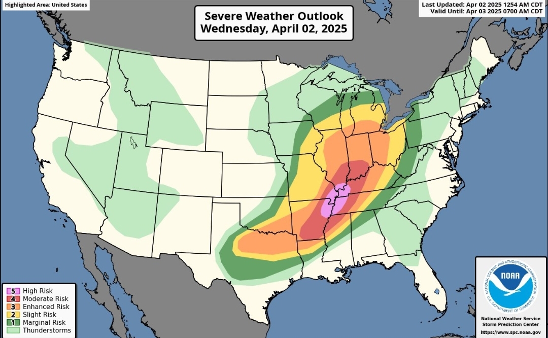
High Risk issued

Posted on 4/2/25 at 5:18 am to Tackleberry
Currently (MyRadar app) ; YIKES


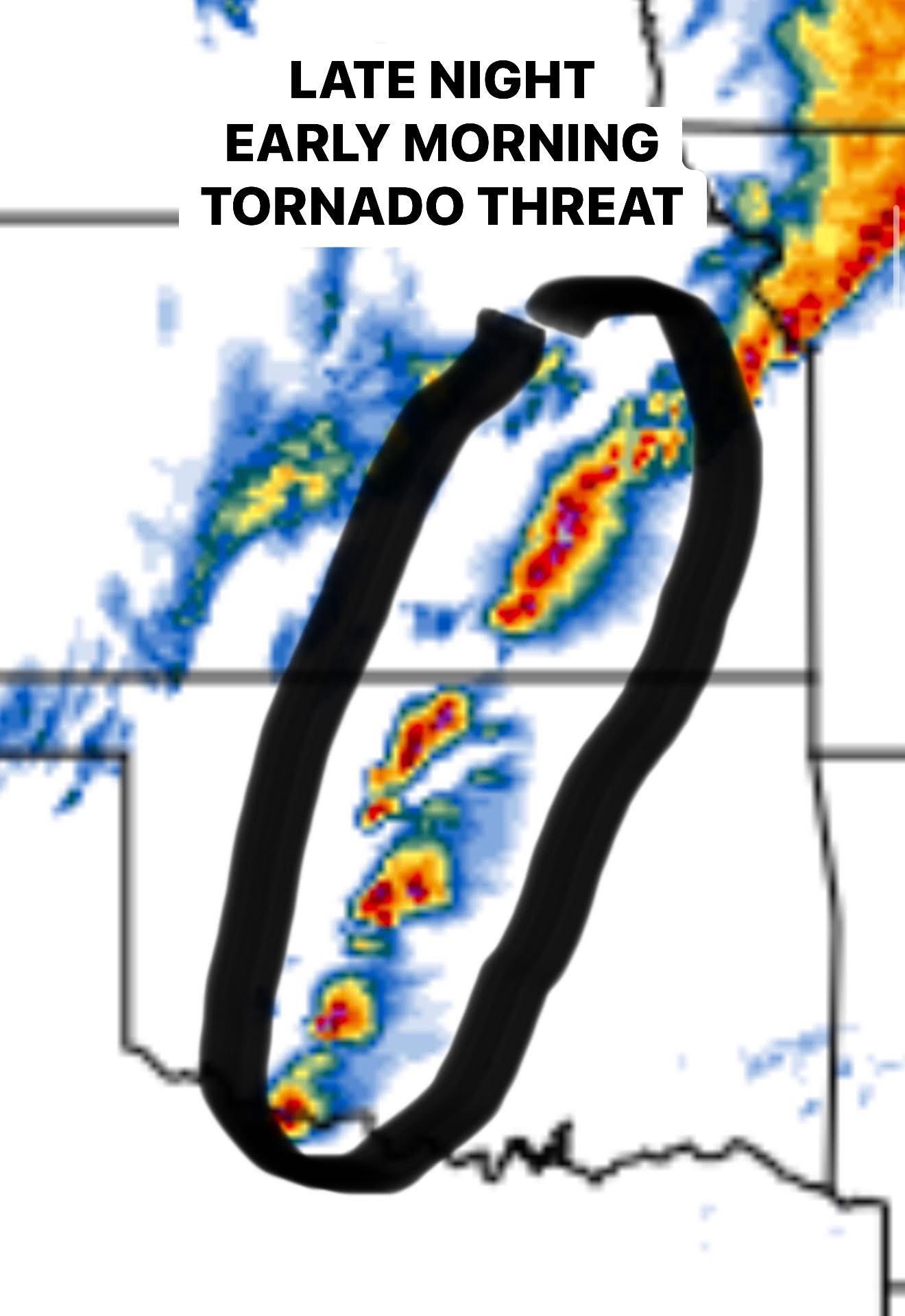
Posted on 4/2/25 at 5:42 am to OU Guy
Tornado probabilities today from SPC:

Posted on 4/2/25 at 7:45 am to Roll Tide Ravens
Posted on 4/2/25 at 7:45 am to OU Guy
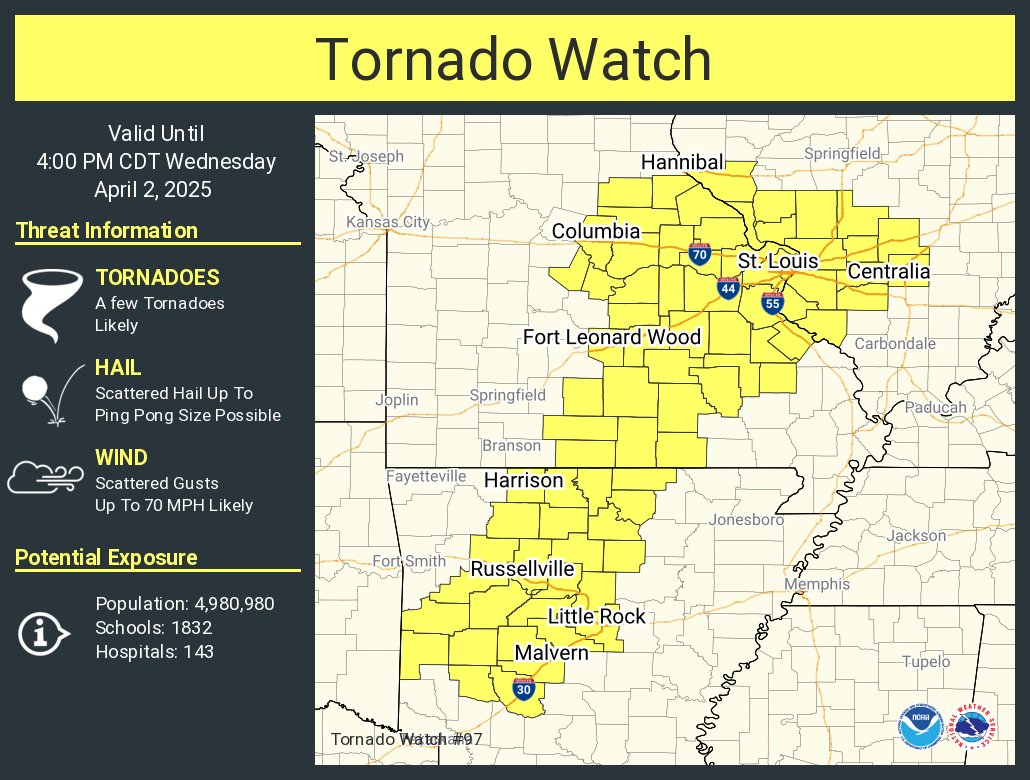
Nasty storm in SW Missouri, near the cities of Nevada and Walker. It has a history of producing a tornado.

Posted on 4/2/25 at 7:46 am to OU Guy
Posted on 4/2/25 at 7:56 am to Tackleberry
Pretty surprised this got a high risk
Battin down the hatches I reckon
Battin down the hatches I reckon
Posted on 4/2/25 at 8:59 am to OU Guy
This post was edited on 4/2/25 at 9:00 am
Posted on 4/2/25 at 9:07 am to OU Guy
It’s funny to me that these weather threads actually piss some people off. Looks like almost every post has at least one downvote, indicating that someone dislikes this thread enough to downvote nearly every post.
Crazy idea: just ignore this thread if you aren’t interested in it. It’s not harming anyone. If we can have multiple threads a day about teachers molesting students, then I think it’s okay to have one weather thread for those of us who are interested in the topic.
Crazy idea: just ignore this thread if you aren’t interested in it. It’s not harming anyone. If we can have multiple threads a day about teachers molesting students, then I think it’s okay to have one weather thread for those of us who are interested in the topic.

Posted on 4/2/25 at 9:21 am to Roll Tide Ravens
This front is going to absolutely frick us over the next 3-4 days. Severe storms tonight in front but it's going to stall and dump 1997 levels of rain over the next 3 days.
We had four identified F1 tornados (one not too far from the house) the other night.
Loading Twitter/X Embed...
If tweet fails to load, click here. We had four identified F1 tornados (one not too far from the house) the other night.
Posted on 4/2/25 at 9:41 am to BluegrassBelle
NWS Memphis is calling the forecasted flooding “potentially devastating.”
Posted on 4/2/25 at 9:44 am to OU Guy
Updated SPC severe weather outlook for today. The high risk area has been expanded a bit.

This post was edited on 4/2/25 at 9:44 am
Posted on 4/2/25 at 9:49 am to Roll Tide Ravens
Leaving for work this morning I could tell it’s going to be a nasty day with how it felt outside.
Looks like when I’m heading home this afternoon, it will be arriving here in Little Rock.
Looks like when I’m heading home this afternoon, it will be arriving here in Little Rock.

 Page 3 of 4

Popular
Back to top