- My Forums
- Tiger Rant
- LSU Recruiting
- SEC Rant
- Saints Talk
- Pelicans Talk
- More Sports Board
- Fantasy Sports
- Golf Board
- Soccer Board
- O-T Lounge
- Tech Board
- Home/Garden Board
- Outdoor Board
- Health/Fitness Board
- Movie/TV Board
- Book Board
- Music Board
- Political Talk
- Money Talk
- Fark Board
- Gaming Board
- Travel Board
- Food/Drink Board
- Ticket Exchange
- TD Help Board
Customize My Forums- View All Forums
- Show Left Links
- Topic Sort Options
- Trending Topics
- Recent Topics
- Active Topics
Started By
Message

 2
2

Posted on 2/28/17 at 10:52 pm to rds dc
Is Memphis mostly in the clear overnight on this one? Local news hasn't given an update and I want to know how peacefully I can sleep.
Posted on 2/28/17 at 10:53 pm to rds dc
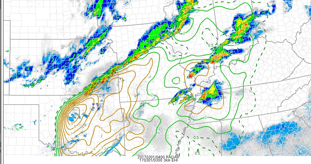
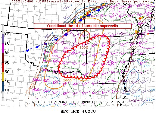
New tornado watch coming for N. TX, OK, and Arky:
Mesoscale Discussion 0230
NWS Storm Prediction Center Norman OK
1046 PM CST Tue Feb 28 2017
Areas affected...Eastern Oklahoma into western Arkansas
Concerning...Severe potential...Tornado Watch likely
Valid 010446Z - 010645Z
Probability of Watch Issuance...80 percent
SUMMARY...Isolated to scattered severe thunderstorms may develop in
the next few hours over eastern Oklahoma into western Arkansas.
Tornadoes and very large hail are possible.
DISCUSSION...Showers appear to be deepening across parts of eastern
Oklahoma, in advance of strong cooling aloft and approaching the
surface moist axis where dewpoints are in the lower 60s. Due to
strong winds and mixing, the boundary layer remains warm with
temperatures in the 70s and relatively weak CIN. Given extreme
cooling aloft, lapse rates are very steep, with MLCAPE to around
2000 J/kg. Shear is more impressive, with area VWPs indicating 0-1
SRH in excess of 500 to 600 m2/s2. Clearly, the environment favors
tornadic supercells, conditional on storms forming. Several CAM
solutions indicate storms in this area. A tornado watch is likely to
be needed soon.
..Jewell/Edwards.. 03/01/2017

 Page 1 of 1


Popular
Back to top