- My Forums
- Tiger Rant
- LSU Recruiting
- SEC Rant
- Saints Talk
- Pelicans Talk
- More Sports Board
- Fantasy Sports
- Golf Board
- Soccer Board
- O-T Lounge
- Tech Board
- Home/Garden Board
- Outdoor Board
- Health/Fitness Board
- Movie/TV Board
- Book Board
- Music Board
- Political Talk
- Money Talk
- Fark Board
- Gaming Board
- Travel Board
- Food/Drink Board
- Ticket Exchange
- TD Help Board
Customize My Forums- View All Forums
- Show Left Links
- Topic Sort Options
- Trending Topics
- Recent Topics
- Active Topics
Started By
Message
re: Flood threat on northern Gulf coast
Posted on 8/8/16 at 9:45 pm to GEAUXmedic
Posted on 8/8/16 at 9:45 pm to GEAUXmedic
quote:
NATIONAL WEATHER SERVICE NEW ORLEANS LA
They should check the legend in a test environment before posting live. You can't read it, esp. on mobile. Overall, the flood threat has actually decreased over the past several days as the models have trended towards any surface feature being farther inland. The runs that really hammered the coast kept a broad low near the Gulf and smaller vorts kept spinning up and rotating onshore, focusing heavy rain on the area. Also, the front has trended stronger and is lifting this junk out a little faster.
 3
3


Posted on 8/8/16 at 9:52 pm to rds dc
Yep, saw some drama queens freaking out in other threads when the euro was showing 40"+ of rain. Most knew that wasnt going to happen but because the euro showed it, must be true. 
Posted on 8/8/16 at 9:52 pm to rds dc
quote:
Overall, the flood threat has actually decreased over the past several days as the models have trended towards any surface feature being farther inland.
The precip totals it WAS showing were ridiculous, the more realistic totals now are still not good at all.
Posted on 8/9/16 at 9:49 pm to rds dc
quote:
quote:
NATIONAL WEATHER SERVICE NEW ORLEANS LA
They should check the legend in a test environment before posting live. You can't read it, esp. on mobile.
Much better graphic issued today:
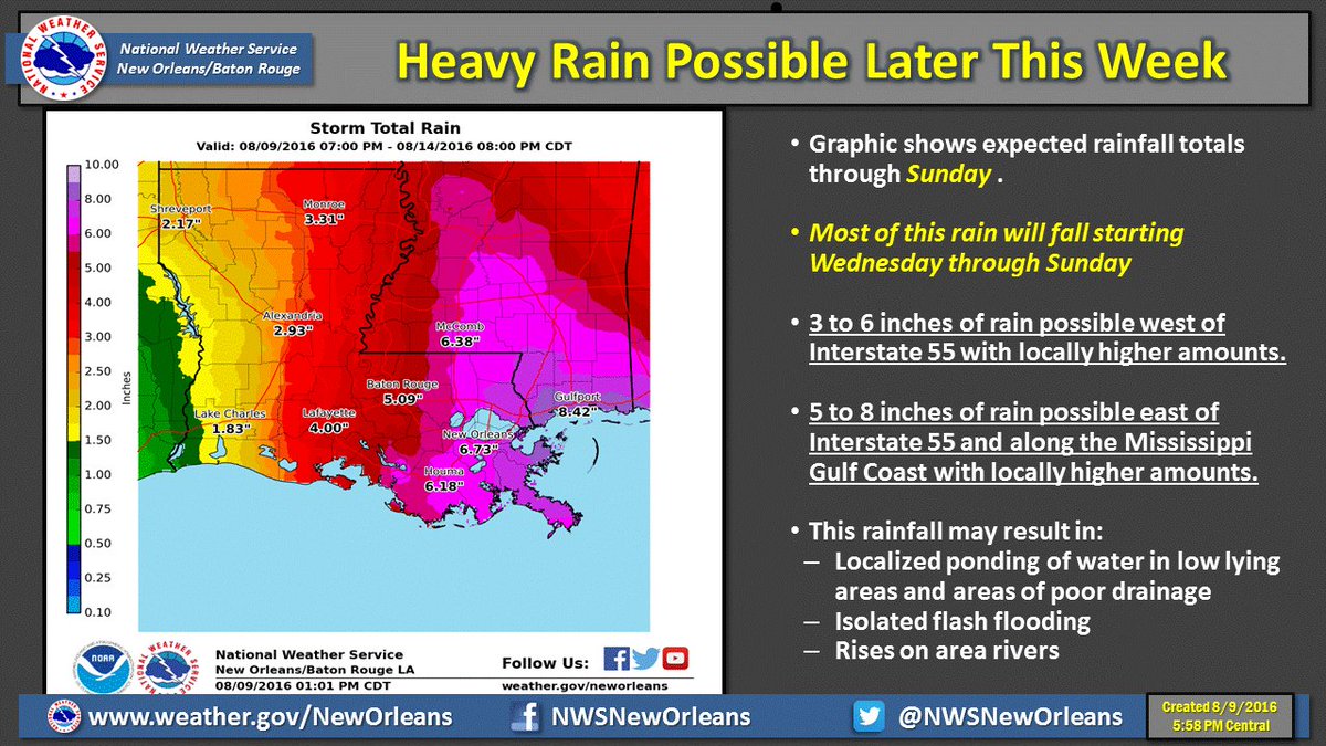
Some concerning changes with the 12z Euro today showing 8-16"+ for areas north of I10 and east of the River by Monday morning. This is a pretty short range forecast for the Euro and a time frame where it typically is pretty good. It is also backed up by the Euro EPS which shows a 51 member mean of nearly 8" for the same area. If it holds at 00z to the next 24 hrs, I would suspect a pretty significant expansion of the Flood Watch.

 Page 1 of 1


Popular
Back to top