- My Forums
- Tiger Rant
- LSU Recruiting
- SEC Rant
- Saints Talk
- Pelicans Talk
- More Sports Board
- Fantasy Sports
- Golf Board
- Soccer Board
- O-T Lounge
- Tech Board
- Home/Garden Board
- Outdoor Board
- Health/Fitness Board
- Movie/TV Board
- Book Board
- Music Board
- Political Talk
- Money Talk
- Fark Board
- Gaming Board
- Travel Board
- Food/Drink Board
- Ticket Exchange
- TD Help Board
Customize My Forums- View All Forums
- Show Left Links
- Topic Sort Options
- Trending Topics
- Recent Topics
- Active Topics
Started By
Message
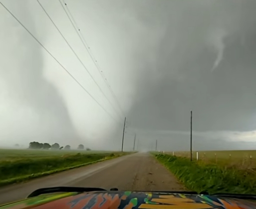
Large tornado forming in far northern Oklahoma south of Wichita - Reed Timmer / Ryan Hall
Posted on 4/23/26 at 6:36 pm
Posted on 4/23/26 at 6:36 pm
This post was edited on 4/23/26 at 7:13 pm
 6
6

Posted on 4/23/26 at 6:40 pm to NorthEndZone
The radar on the one just north of Blackwell looks gnarly. Not sure if that’s the one these guys are following.
Posted on 4/23/26 at 6:42 pm to beaverfever
Yeah that's it. NW of Blackwell.
Braman, OK is in the path.
Braman, OK is in the path.
This post was edited on 4/23/26 at 6:47 pm

Posted on 4/23/26 at 6:47 pm to NorthEndZone
They up in it
Posted on 4/23/26 at 6:50 pm to Nado Jenkins83
That was a great shot.
Posted on 4/23/26 at 6:56 pm to NorthEndZone
Ryan Hall has multiple chasers on it
Posted on 4/23/26 at 7:06 pm to SidewalkTiger
Thanks. I'm on his feed now. Watching both.
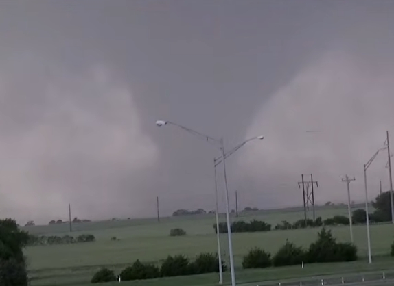
Multi-vortex on stream near I-35 now.
Multi-vortex on stream near I-35 now.
quote:
BULLETIN - EAS ACTIVATION REQUESTED
Tornado Warning
National Weather Service Norman OK
708 PM CDT Thu Apr 23 2026
The National Weather Service in Norman has issued a
* Tornado Warning for...
Northwestern Kay County in northern Oklahoma...
* Until 800 PM CDT.
* At 708 PM CDT, a confirmed large and extremely dangerous tornado
was located 4 miles southwest of Braman, moving east at 20 mph.
This is a PARTICULARLY DANGEROUS SITUATION. TAKE COVER NOW!
HAZARD...Damaging tornado.
SOURCE...Broadcast media confirmed tornado.
IMPACT...You are in a life-threatening situation. Flying debris
may be deadly to those caught without shelter. Mobile
homes will be destroyed. Considerable damage to homes,
businesses, and vehicles is likely and complete
destruction is possible.
* Locations impacted include...
Braman, Peckham, and Blackwell Lake.
This includes Interstate 35 between mile markers 225 and 235.
This post was edited on 4/23/26 at 7:09 pm
Posted on 4/23/26 at 7:09 pm to NorthEndZone
Posted on 4/23/26 at 7:13 pm to SidewalkTiger
Posted on 4/23/26 at 7:25 pm to SidewalkTiger
Posted on 4/23/26 at 7:26 pm to SidewalkTiger
Reed Timmer is hung up in a field
Posted on 4/23/26 at 7:28 pm to JoeyP239
Yeah. They got too close and winds on fringe of tornado blew them off road.
Posted on 4/23/26 at 7:42 pm to NorthEndZone
Yea that tornado backed up on him hard.
I was concerned for them not gonna lie.
Fortunately the debris was mostly dirt.
I was concerned for them not gonna lie.
Fortunately the debris was mostly dirt.
Posted on 4/23/26 at 8:05 pm to razorbackfan4life
Farmers with a big John Deere pulled the Dominator out of the mud.
Posted on 4/23/26 at 8:11 pm to NorthEndZone
Love our farmers. Just salt of the earth people.
Posted on 4/23/26 at 8:16 pm to razorbackfan4life
PDS tornado south of Enid.
Posted on 4/23/26 at 8:17 pm to razorbackfan4life
Yeah. Relatives used to have a farm in central Ark years ago.
PDS warning for Enid, OK
PDS warning for Enid, OK
quote:
813 PM CDT Thu Apr 23 2026
...A TORNADO WARNING REMAINS IN EFFECT UNTIL 845 PM CDT FOR CENTRAL
GARFIELD COUNTY...
At 813 PM CDT, a confirmed large and extremely dangerous tornado was
located near Vance Air Force Base, moving east at 25 mph.
This is a PARTICULARLY DANGEROUS SITUATION. TAKE COVER NOW!
HAZARD...Damaging tornado.
SOURCE...Emergency management confirmed tornado.
IMPACT...You are in a life-threatening situation. Flying debris may
be deadly to those caught without shelter. Mobile homes
will be destroyed. Considerable damage to homes,
businesses, and vehicles is likely and complete destruction
is possible.
Locations impacted include...
Enid, Waukomis, Covington, Breckenridge, Fairmont, Vance Air Force
Base, and North Enid.
Posted on 4/23/26 at 8:19 pm to NorthEndZone
Posted on 4/23/26 at 8:20 pm to NorthEndZone
Posted on 4/23/26 at 8:23 pm to OU Guy
Enid, OK


 Page 1 of 3

Popular
Back to top