- My Forums
- Tiger Rant
- LSU Recruiting
- SEC Rant
- Saints Talk
- Pelicans Talk
- More Sports Board
- Fantasy Sports
- Golf Board
- Soccer Board
- O-T Lounge
- Tech Board
- Home/Garden Board
- Outdoor Board
- Health/Fitness Board
- Movie/TV Board
- Book Board
- Music Board
- Political Talk
- Money Talk
- Fark Board
- Gaming Board
- Travel Board
- Food/Drink Board
- Ticket Exchange
- TD Help Board
Customize My Forums- View All Forums
- Show Left Links
- Topic Sort Options
- Trending Topics
- Recent Topics
- Active Topics
Started By
Message

Severe weather thread 5/6: It's Texas's turn
Posted on 5/6/25 at 9:17 am

Posted on 5/6/25 at 9:17 am

This post was edited on 5/6/25 at 9:25 am
 11
11

Posted on 5/6/25 at 9:19 am to Dire Wolf
Just a normal spring day in North Texas.
ETA:
ETA:
quote:Congrats on your de-extinction
Dire Wolf
This post was edited on 5/6/25 at 9:21 am
Posted on 5/6/25 at 10:25 am to 214
Yep...has already come and gone up here
Posted on 5/6/25 at 10:57 am to Dire Wolf
We got hail in SE New Mexico last night.

Posted on 5/6/25 at 11:00 am to 214
Going to rain here until Saturday. Remind me in July that I was bitching about rain in May 
Posted on 5/6/25 at 11:01 am to LSUGrrrl
Just got dark as 8:00 pm as I typed that post.
Posted on 5/6/25 at 11:05 am to LSUGrrrl
Real dark...damn!
It's night time
It's night time
This post was edited on 5/6/25 at 11:06 am

Posted on 5/6/25 at 11:07 am to Dire Wolf
Just blew through Denton. Heavy lightning and rain. Got pretty dark.
Posted on 5/6/25 at 11:07 am to 214
It’s raining sideways but from 3 different sides

Posted on 5/6/25 at 11:11 am to LSUGrrrl
No school cancellations yet for south la tomorrow? Hrrr showing 10” for some areas. Cant let little brayleigh melt in the rain waiting for the carpool
Posted on 5/6/25 at 11:16 am to Cosmo

Posted on 5/6/25 at 11:19 am to AllDayEveryDay
Yesterday I heard thunder that lasted a solid 10 seconds. It was strange
Posted on 5/6/25 at 11:25 am to 214
Tornado trying hard to get it together SE of Waco near Rosebud, TX.

Posted on 5/6/25 at 11:27 am to Dire Wolf
I'm mostly worried about the hail.
Posted on 5/6/25 at 11:27 am to LSUGrrrl
I'm gonna need a boat.
Posted on 5/6/25 at 11:31 am to 214

Posted on 5/6/25 at 11:32 am to TrueTiger
Where are you?
Posted on 5/6/25 at 11:33 am to LSUGrrrl
What if this is really the end?
I lived a good life but I had plans and stuff
I lived a good life but I had plans and stuff
Posted on 5/6/25 at 11:42 am to 214
quote:
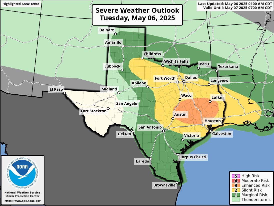
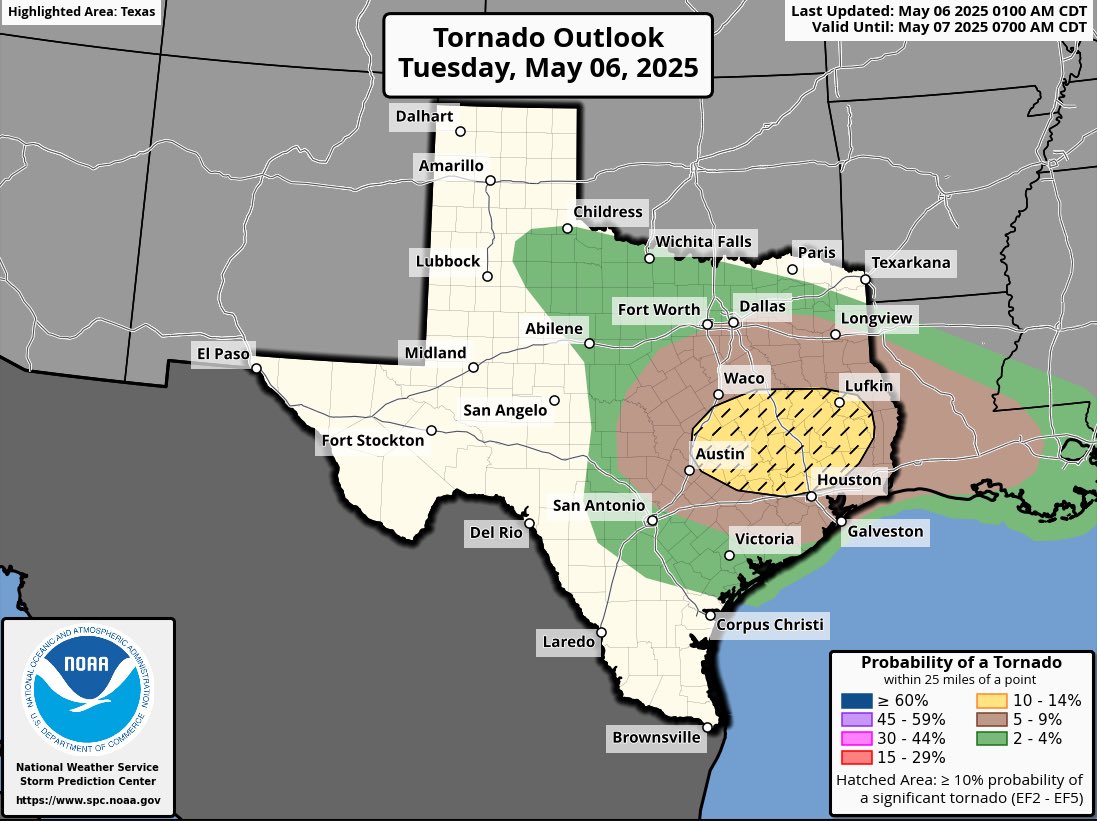
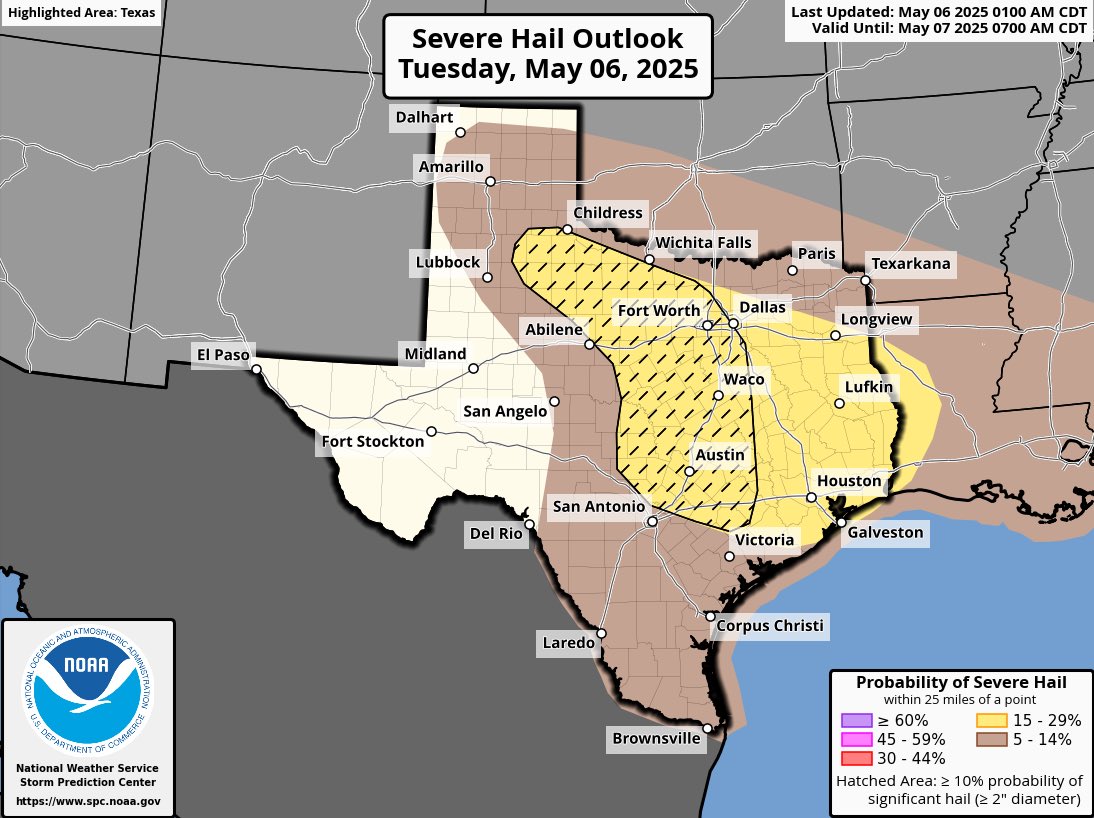
From the most recent Mesoscale discussion from SPC (seen above) - Mesoscale Discussion 0715 NWS Storm Prediction Center Norman OK 1050 AM CDT Tue May 06 2025 Areas affected...Central to East-Central Texas Concerning...Tornado Watch 231... Valid 061550Z - 061715Z The severe weather threat for Tornado Watch 231 continues. SUMMARY...The tornado threat will increase late this morning into the early afternoon across parts of central and east-central Texas. DISCUSSION...Low-level moisture advection has resulted in increasing instability along the warm front in central/east-central Texas with low 70s dewpoints now present across this region. Cloud cover has limited heating thus far, but some breaks in the clouds have become apparent and should allow for heating into the early afternoon. A mature supercell already exists along this frontal zone in Bell County, Texas. Expect this cell to continue east along the front with an increasing tornado threat through the afternoon. Additional development has already started to the southwest with some hints of additional development farther east along the front. By later this afternoon, expect several supercells along and south of the warm front with a primary threat for large hail and tornadoes (some of which could be strong). The primary limiting factor based on 12Z forecast soundings was moist/neutral lapse rates in the low levels. However, at least some heating is already apparent south of the front which could result in low 80s temperatures and more favorable low-level lapse rates. Therefore, concern is increasing for an evolving tornado threat across east-central Texas. ..Bentley.. 05/06/2025 ...Please see www.spc.noaa.gov for graphic product... ATTN...WFO...HGX...FWD...EWX... LAT...LON 30969806 31369711 31399570 31279530 30919512 30159504 29589507 29479653 29549797 29559828 29659858 29849859 30969806 MOST PROBABLE PEAK TORNADO INTENSITY...120-150 MPH MOST PROBABLE PEAK WIND GUST...55-70 MPH MOST PROBABLE PEAK HAIL SIZE...1.50-2.50 IN
Posted on 5/6/25 at 11:46 am to 214
Ha! We will be begging for 4 straight days of rain in a few months.

 Page 1 of 6

Popular
Back to top