- My Forums
- Tiger Rant
- LSU Recruiting
- SEC Rant
- Saints Talk
- Pelicans Talk
- More Sports Board
- Fantasy Sports
- Golf Board
- Soccer Board
- O-T Lounge
- Tech Board
- Home/Garden Board
- Outdoor Board
- Health/Fitness Board
- Movie/TV Board
- Book Board
- Music Board
- Political Talk
- Money Talk
- Fark Board
- Gaming Board
- Travel Board
- Food/Drink Board
- Ticket Exchange
- TD Help Board
Customize My Forums- View All Forums
- Show Left Links
- Topic Sort Options
- Trending Topics
- Recent Topics
- Active Topics
Started By
Message
re: Severe Weather Rolls On: May 7-10, 2024
Posted on 5/8/24 at 1:54 pm to Roll Tide Ravens

Posted on 5/8/24 at 1:54 pm to Roll Tide Ravens
I’m surprised this storm south of St. Louis doesn’t have a tornado warning on it yet.

 2
2

Posted on 5/8/24 at 1:57 pm to Roll Tide Ravens
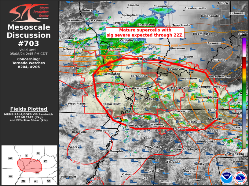
Mesoscale Discussion 0703
NWS Storm Prediction Center Norman OK
0150 PM CDT Wed May 08 2024
Areas affected...parts of the Mid-MS...Lower OH...and TN Valleys
Concerning...Tornado Watch 204...206...
Valid 081850Z - 081945Z
The severe weather threat for Tornado Watch 204, 206 continues.
SUMMARY...Very large hail, isolated severe wind gusts, and tornadoes
will remain probable with mature supercells across parts of the
Mid-Mississippi to Lower Ohio and Tennessee Valleys through the rest
of the afternoon.
DISCUSSION...Several supercells are ongoing with two distinct
regimes. An intense, long-track supercell in cluster regime persists
across a part of the Mid-MS Valley, between STL and CGI. Numerous
large hail up to baseball size have been reported during the past
hour. This supercell cluster should continue to evolve east along
the tight instability gradient across southern IL, with potential
for further upscale growth along its southwest flank. Damaging winds
of 70-80 mph, along with attempts at occasional tornadogenesis will
remain possible.
Farther southeast, more discrete supercells continue to
increase/mature. Low-level SRH is relatively greater across
south-central KY into northern Middle TN near/northeast of the
residual outflow from the morning MCS. Low-level flow has become
veered to the southwest per time-series of PAH VWP data, tempering
warm-sector hodograph enlargement. Overall, a mix of all severe
hazards, some of which may be significant, is anticipated in/near
both tornado watches through 22Z.
..Grams.. 05/08/2024
Posted on 5/8/24 at 1:57 pm to Roll Tide Ravens
quote:
I’m surprised this storm south of St. Louis doesn’t have a tornado warning on it yet.
Tornado warning for it now.

 Page 1 of 1


Popular
Back to top