- My Forums
- Tiger Rant
- LSU Recruiting
- SEC Rant
- Saints Talk
- Pelicans Talk
- More Sports Board
- Fantasy Sports
- Golf Board
- Soccer Board
- O-T Lounge
- Tech Board
- Home/Garden Board
- Outdoor Board
- Health/Fitness Board
- Movie/TV Board
- Book Board
- Music Board
- Political Talk
- Money Talk
- Fark Board
- Gaming Board
- Travel Board
- Food/Drink Board
- Ticket Exchange
- TD Help Board
Customize My Forums- View All Forums
- Show Left Links
- Topic Sort Options
- Trending Topics
- Recent Topics
- Active Topics
Started By
Message
 6
6

Posted on 5/6/24 at 10:24 pm to BigBro
I mena if that is even remotely close that would be an EF5
Posted on 5/6/24 at 10:24 pm to BigBro
Storms are based on damage and not wind unfortunately. Maybe they will change that in the future.
Posted on 5/6/24 at 10:25 pm to BigBro
Man if that verifies 250 mph is insane
Posted on 5/6/24 at 10:27 pm to BigBro

Posted on 5/6/24 at 10:30 pm to BigBro
quote:
250 mph reported at airport
250mph before it broke
Yikes
Posted on 5/6/24 at 10:51 pm to BigBro
quote:
in the Reed Timmer chat, there are some saying 250 mph reported at airport near Bartlesville.. that’s a strong F4 if it’s verified.. stay safe out there
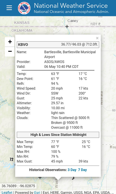
I doubt this very seriously. In fact, I'm just gonna outright call bullshite. The tornadic part of the storm missed the airport, and the publicly accessible weather station at the airport recorded a 45mph max gust, and it is still reporting as of 10:40pm.
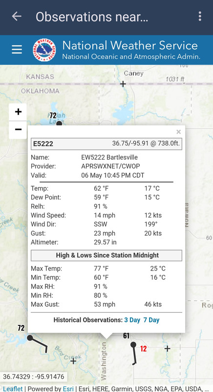
The other station near Bartlesville would have been closer to the tornado, and it recorded a max gust of 53mph and is still reporting as of 10:45pm.
This post was edited on 5/6/24 at 10:55 pm

 Page 1 of 1


Popular
Back to top