- My Forums
- Tiger Rant
- LSU Recruiting
- SEC Rant
- Saints Talk
- Pelicans Talk
- More Sports Board
- Fantasy Sports
- Golf Board
- Soccer Board
- O-T Lounge
- Tech Board
- Home/Garden Board
- Outdoor Board
- Health/Fitness Board
- Movie/TV Board
- Book Board
- Music Board
- Political Talk
- Money Talk
- Fark Board
- Gaming Board
- Travel Board
- Food/Drink Board
- Ticket Exchange
- TD Help Board
Customize My Forums- View All Forums
- Show Left Links
- Topic Sort Options
- Trending Topics
- Recent Topics
- Active Topics
Started By
Message
re: Ian Observation Thread (Storm Track and Radar inside)
Posted on 9/26/22 at 8:18 pm to SabineRat

Posted on 9/26/22 at 8:18 pm to SabineRat
So Tampa it is unless something drastic changes. The models are all locked in.
The last domino were the Euro ensembles and they're actually slightly south of Tampa.
The last domino were the Euro ensembles and they're actually slightly south of Tampa.
This post was edited on 9/26/22 at 8:21 pm
 2
2

Posted on 9/26/22 at 8:23 pm to Oates Mustache
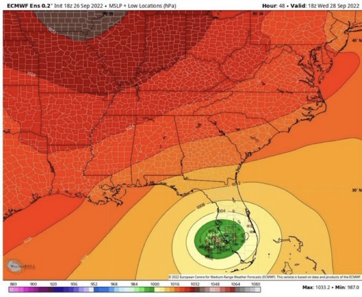
The 18z Euro is pretty much a worst case for Tampa. It makes landfall, but barely. It then proceeds to keep them in the eyewall for something like 12 hours as it slows.
We're also looking at the potential for well over a foot of rain across a swath of FL as it just meanders.
We're also looking at the potential for well over a foot of rain across a swath of FL as it just meanders.
This post was edited on 9/26/22 at 8:26 pm
Posted on 9/26/22 at 8:23 pm to Oates Mustache
Some reports I read have it staying just off coast up the western side of FL and even slowing by Tampa which is worst case scenario because winds are stronger on south and east sides. If true that means a lot of storn surge all over plus huge rain/flooding inland. The reports said no landfall before Tampa. Staying off coast means it keeps its power longer no shearing
This post was edited on 9/26/22 at 8:25 pm

 Page 1 of 1


Popular
Back to top