- My Forums
- Tiger Rant
- LSU Recruiting
- SEC Rant
- Saints Talk
- Pelicans Talk
- More Sports Board
- Fantasy Sports
- Golf Board
- Soccer Board
- O-T Lounge
- Tech Board
- Home/Garden Board
- Outdoor Board
- Health/Fitness Board
- Movie/TV Board
- Book Board
- Music Board
- Political Talk
- Money Talk
- Fark Board
- Gaming Board
- Travel Board
- Food/Drink Board
- Ticket Exchange
- TD Help Board
Customize My Forums- View All Forums
- Show Left Links
- Topic Sort Options
- Trending Topics
- Recent Topics
- Active Topics
Started By
Message

Tornado! Threat Shifting East
Posted on 4/13/18 at 12:52 pm
Posted on 4/13/18 at 12:52 pm
This post was edited on 4/14/18 at 11:55 am
 22
22

Posted on 4/13/18 at 12:53 pm to rds dc
hang in there Paul
Posted on 4/13/18 at 12:54 pm to rds dc
NW Louisiana, including Shreveport, need to keep a close eye on things today. That watch may be PDS.
This post was edited on 4/13/18 at 12:55 pm

Posted on 4/13/18 at 12:55 pm to rds dc
That looks like today.... not good for that area.... the southern parts of LA will get hammered tomorrow between 10-4......

Posted on 4/13/18 at 12:55 pm to rds dc
Y'all be careful up there. Witches be bitches.
Posted on 4/13/18 at 12:55 pm to rds dc
I got hail damage last weekend in shrevesport.
Dont need more.
But we have been anticipating this for a couple days now up here
Dont need more.
But we have been anticipating this for a couple days now up here
Posted on 4/13/18 at 12:55 pm to dukke v
quote:
the southern parts of LA will get hammered tomorrow between 10-4....
quote:
dukke v
Posted on 4/13/18 at 12:58 pm to rds dc
quote:
NW Louisiana, including Shreveport, need to keep a close eye on things today. That watch may be PDS.
There's an old civil defense shelter nearby that is under ground level and has about three feet of concrete above it. D.A. owns it, I've already told him that is where I'm going if some F4 or F5 is rolling towards me - even if I have to break in LOL. Of course, I would only do it if it on the ground and approaching.
Posted on 4/13/18 at 12:58 pm to dukke v
quote:
That looks like today.... not good for that area.... the southern parts of LA will get hammered tomorrow between 10-4......
Tomorrow should be more of strong line of storms with straight line winds and flash flooding being the primary threats. The tornado threat looks highest later in the day in Alabama.

Posted on 4/13/18 at 1:00 pm to dukke v
quote:
the southern parts of LA will get hammered tomorrow between 10-4......
quote:
dukke v
Oh thank God!

Posted on 4/13/18 at 1:01 pm to chinhoyang
quote:
hat is where I'm going if some F4 or F5 is rolling towards me
quote:
I would only do it if it on the ground
Yea, an F4 or F5 in the air is just one big pussyfart.
Posted on 4/13/18 at 1:01 pm to rds dc
This NWS link used to be great - click on any state and get all the weather information. Then, they screwed it up. You have to click on the map, select the product you want (e.g. forecast discussion), then click the weather service city.
Former Best Weather Info
Former Best Weather Info
Posted on 4/13/18 at 1:04 pm to TDsngumbo
quote:
Yea, an F4 or F5 in the air is just one big pussyfart.
There's a below ground room that is open but one side has chain link fence rather than a wall. It would be a good spot but for a big one there's a double door to get into the civil defense shelter.
Posted on 4/13/18 at 1:04 pm to chinhoyang
The NWS Now app is great. Official NWS observations, forecast, warnings and discussion in an easy to read format. No ads, no clickbait, just the information. The radar feature is not as good as I would like, but it has everything else.
Posted on 4/13/18 at 1:14 pm to rds dc
quote:
NW Louisiana, including Shreveport, need to keep a close eye on things today. That watch may be PDS.
quote:
DISCUSSION...Radar/satellite imagery shows a band of elevated
convection extending from Pushmataha/Choctaw counties OK southward
into Kaufman/Navarro counties TX. Some increase in intensity has
been noted in the past hour, although activity remains sub-severe.
A substantial capping inversion was in place over this region at
12z, but the 18z FWD/LZK soundings indicate rapid cooling at the
base of the EML and a diminishing cap. Given current trends, the
thunderstorm activity may become surface-based in the next couple of
hours.
Strong low-level wind fields will remain in place ahead of the
convection, and may increase through early evening. Local VAD
profiles already show 0-3 km SRH values of 300-400 m2/s2 with
forecast soundings suggesting values over 500 m2/s2 this evening.
Assuming activity can remain semi-discrete, a few intense supercells
are likely to evolve. Parameters appear favorable for the risk of
strong tornadoes, along with large hail and damaging winds. PDS
wording is being considered in the tornado watch for this region.
^ Referencing the area over Ark-La-Tex.
Posted on 4/13/18 at 1:17 pm to ksayetiger
If you need an estimate on your roof call Reno at Rain pro roofing and tell him Norm sent you. Great company and they will take care of you.
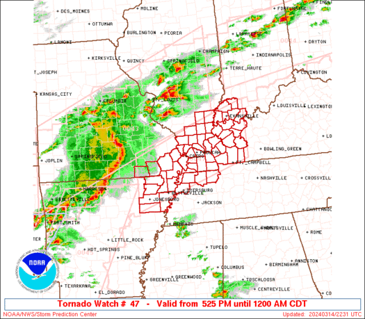
Posted on 4/13/18 at 1:18 pm to slackster
Not exactly what you want to see later this evening (5PM CDT):


Posted on 4/13/18 at 1:35 pm to rds dc
Yall stay safe over there
Posted on 4/13/18 at 1:38 pm to rds dc
Hope I'm off work before this stuff pushes through Fayetteville.

 Page 1 of 24

Popular
Back to top