- My Forums
- Tiger Rant
- LSU Recruiting
- SEC Rant
- Saints Talk
- Pelicans Talk
- More Sports Board
- Fantasy Sports
- Golf Board
- Soccer Board
- O-T Lounge
- Tech Board
- Home/Garden Board
- Outdoor Board
- Health/Fitness Board
- Movie/TV Board
- Book Board
- Music Board
- Political Talk
- Money Talk
- Fark Board
- Gaming Board
- Travel Board
- Food/Drink Board
- Ticket Exchange
- TD Help Board
Customize My Forums- View All Forums
- Show Left Links
- Topic Sort Options
- Trending Topics
- Recent Topics
- Active Topics
Started By
Message
re: Severe Weather Thread: 3/14-3/15
Posted on 3/14/24 at 8:07 pm to Roll Tide Ravens
Posted on 3/14/24 at 8:07 pm to Roll Tide Ravens
MRGA!
i really hope the Ark storm turns out to not be bad
i really hope the Ark storm turns out to not be bad
 1
1


Posted on 3/14/24 at 8:08 pm to Roll Tide Ravens
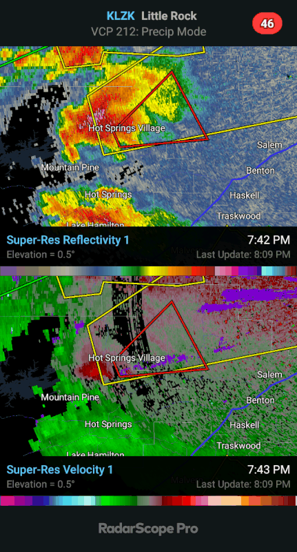
Tornado confirmed in Hot Springs Village. Little Rock might have some trouble soon.

Posted on 3/14/24 at 8:08 pm to Roll Tide Ravens
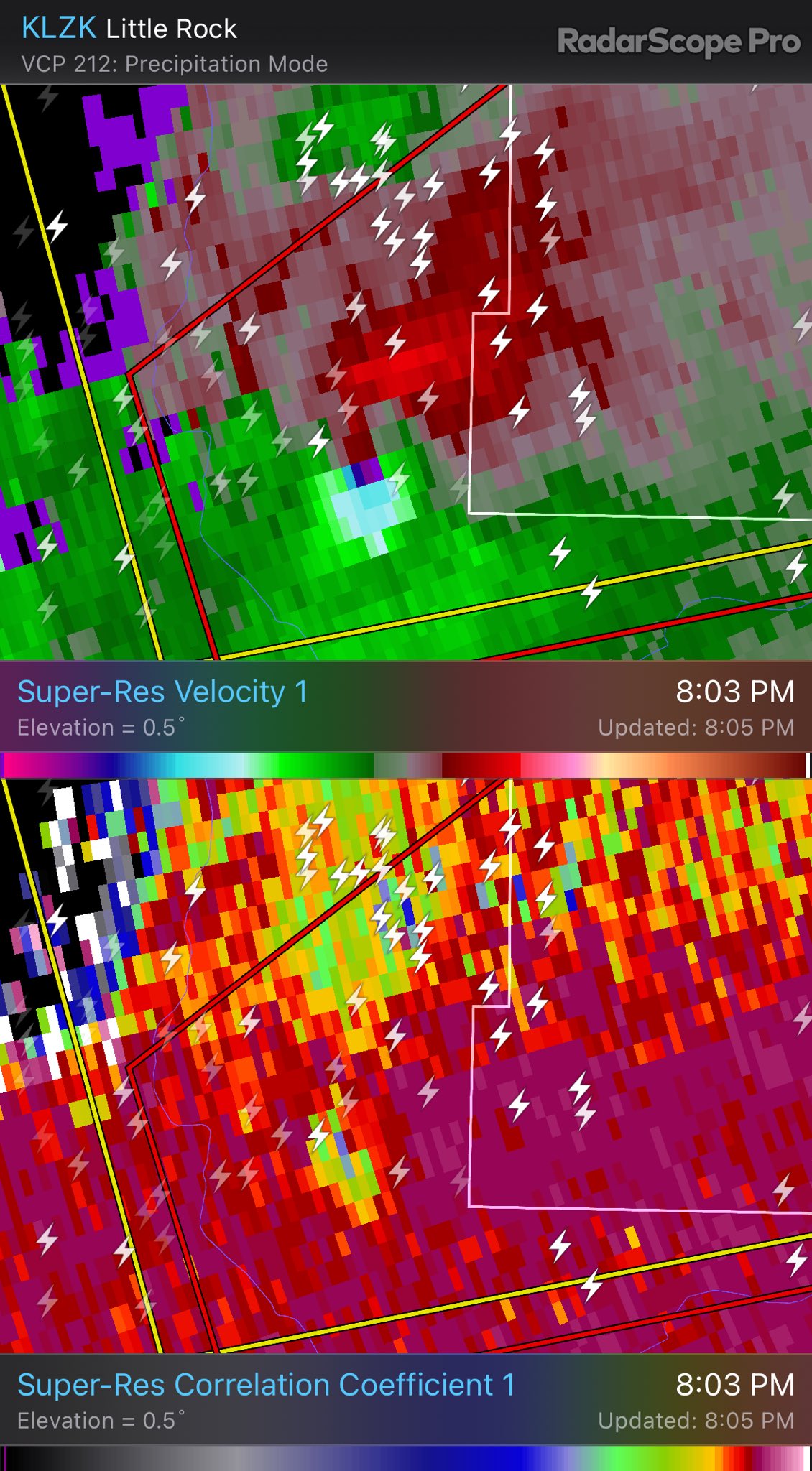
Radar confirmed tornado west of Little Rock. Debris signature on radar.

Posted on 3/14/24 at 8:09 pm to Roll Tide Ravens
Severe Weather Statement
National Weather Service Little Rock AR
806 PM CDT Thu Mar 14 2024
ARC051-125-150130-
/O.CON.KLZK.TO.W.0012.000000T0000Z-240315T0130Z/
Garland AR-Saline AR-
806 PM CDT Thu Mar 14 2024
...A TORNADO WARNING REMAINS IN EFFECT UNTIL 830 PM CDT FOR
NORTHEASTERN GARLAND AND NORTHWESTERN SALINE COUNTIES...
At 805 PM CDT, a confirmed tornado was located over Hot Springs
Village, moving northeast at 25 mph.
HAZARD...Damaging tornado and baseball size hail.
SOURCE...Radar confirmed tornado.
Posted on 3/14/24 at 8:10 pm to Thracken13
James Bryant
@KATVJames
·
1m
TORNADO CONFIRMED IN HOT SPRINGS VILLAGE
Posted on 3/14/24 at 8:10 pm to Roll Tide Ravens
They keep saying baseball sized hail. Hope it continues to be kumquat instead.
Posted on 3/14/24 at 8:11 pm to Roll Tide Ravens
How far is Hot Springs Village from Little Rock?
Posted on 3/14/24 at 8:12 pm to LSUGrrrl
40-50ish min.
Posted on 3/14/24 at 8:13 pm to LegendInMyMind
quote:
Cell merger on the storm west of Little Rock may give it a boost. Already warned and the rotation has tightened up a bit.
That's why you always watch cell mergers. Watch the two cells merge and the boost it gives to the original meso:
Posted on 3/14/24 at 8:14 pm to LSUGrrrl
Garland County Arkansas SKYWARN scanner says confirmed tornado on the ground moving into Saline County from the Hot Springs Village.
Posted on 3/14/24 at 8:17 pm to OU Guy
Just saw your hail pics in the other thread. That hail was crazy! Can’t believe they got that much. Very close to us and we got very little and sounded small.
Posted on 3/14/24 at 8:17 pm to LegendInMyMind
quote:
That's why you always watch cell mergers. Watch the two cells merge and the boost it gives to the original
I thought isolated storms/cells are more tornadic and when merging that can dilute both storms as they line out. Still get hail and high winds and heavy rain but the merge changes energy and dilutes tornados?
Posted on 3/14/24 at 8:19 pm to LSUGrrrl
quote:
Just saw your hail pics in the other thread. That hail was crazy! Can’t believe they got that much. Very close to us and we got very little and sounded small.
Son texted me and said he missed it all in McKinney.
Posted on 3/14/24 at 8:19 pm to OU Guy
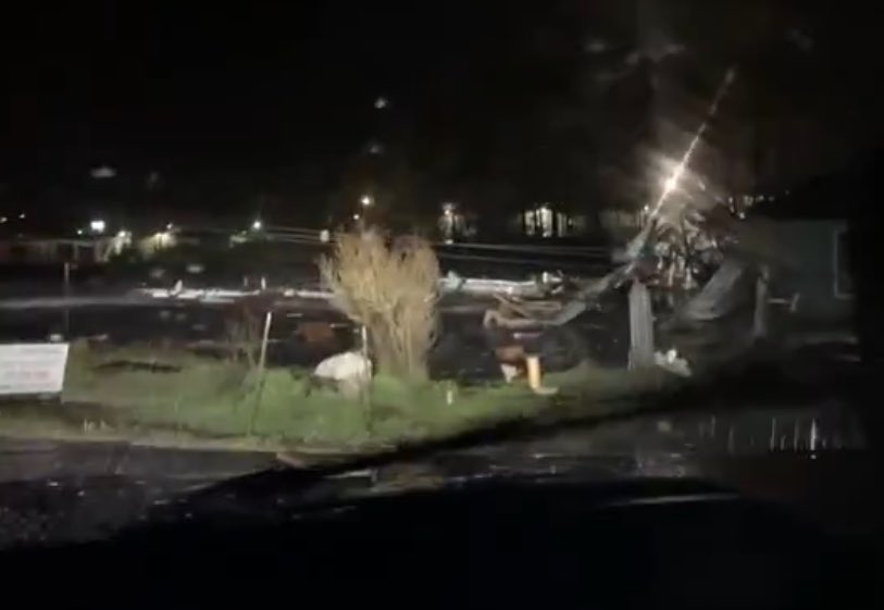
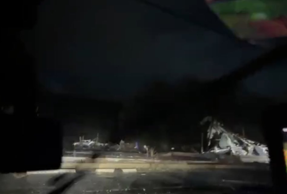
Significant damage to sturdy buildings in Indian Lakes. Citizens are using personal vehicles to recover people from damaged areas and transporting for medical. Also has power lines down in water.
Posted on 3/14/24 at 8:21 pm to OU Guy
quote:
I thought isolated storms/cells are more tornadic and when merging that can dilute both storms as they line out. Still get hail and high winds and heavy rain but the merge changes energy and dilutes tornados?
Not always. Depending on the environment it takes semi-discrete storms merging to put a storm over the top. The merger can change the shear dynamics and help a storm wrap up more efficiently. With some setups you just won't see tornadoes without mergers.
ETA: You see it have more of an impact when storm motions are similar to what we have tonight.
This post was edited on 3/14/24 at 8:24 pm
Posted on 3/14/24 at 8:23 pm to Roll Tide Ravens
Two tornado warnings one 25 miles north and one twenty miles south earlier today. I had paid house insurance about an hour before
Posted on 3/14/24 at 8:24 pm to LegendInMyMind
this is why I love these threads - you guys teach me weather stuff, which was already a fascination of mine.
Posted on 3/14/24 at 8:25 pm to OU Guy
Hawkins
@wx_hawkins
@Jeff_Piotrowski
Buildings slabbed in Hot Springs Village, Arkansas via Jeff’s stream.
@NWSLittleRock
Posted on 3/14/24 at 8:25 pm to OU Guy
HSV is where a lot of money is, I’m guessing buildings there are built well.
Posted on 3/14/24 at 8:27 pm to Thracken13
quote:
this is why I love these threads - you guys teach me weather stuff, which was already a fascination of mine.
Another thing on that storm, you saw it keep clean inflow to the south. So, after the merger it still had good inflow and was able to wrap it up.

 Page 5 of 10

Popular
Back to top