- My Forums
- Tiger Rant
- LSU Recruiting
- SEC Rant
- Saints Talk
- Pelicans Talk
- More Sports Board
- Fantasy Sports
- Golf Board
- Soccer Board
- O-T Lounge
- Tech Board
- Home/Garden Board
- Outdoor Board
- Health/Fitness Board
- Movie/TV Board
- Book Board
- Music Board
- Political Talk
- Money Talk
- Fark Board
- Gaming Board
- Travel Board
- Food/Drink Board
- Ticket Exchange
- TD Help Board
Customize My Forums- View All Forums
- Show Left Links
- Topic Sort Options
- Trending Topics
- Recent Topics
- Active Topics
Started By
Message
 0
0


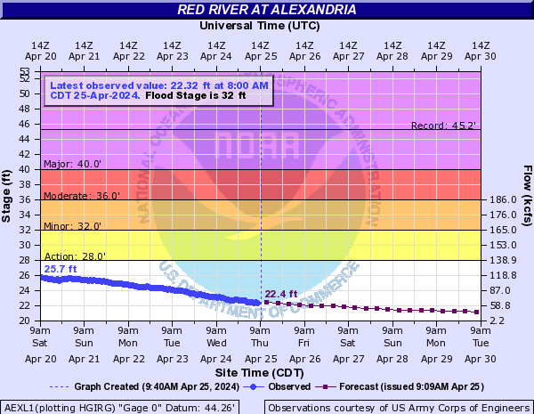
Posted on 5/28/19 at 9:37 pm to Geauxtiga

If NBR floods,SBR and St G is SCREWED.
See the map (NBR= light color, higher elevation, SBR, darker color)
This post was edited on 5/28/19 at 9:39 pm

Posted on 5/28/19 at 9:39 pm to jimbeam
quote:
SBR, darker color
How dare you!?
Posted on 5/28/19 at 9:40 pm to NewIberiaHaircut
I recognize the irony 

Posted on 5/28/19 at 9:41 pm to jimbeam
That's a cool map.
Posted on 5/28/19 at 9:42 pm to fightin tigers
Well I've lived half my life south of 10.
Posted on 5/28/19 at 10:01 pm to CarRamrod
quote:Pretty sure from my research on the history of Southdowns that the Gideon Church location on that map is/was just to the South of St. Aloysius.
That's a cool map.
ETA: on second thought I may be thinking of the old farmhouse on Mimosa that was torn down in the last... decade? Looks like Gideon was closer to Perkins Road.
This post was edited on 5/28/19 at 10:06 pm
Posted on 5/28/19 at 10:04 pm to slackster
is there a possibility that certain areas of br or nola could flood? sorry haven’t been keeping up with this at all and it’s hard just skimming this thread to get the right info.
Posted on 5/28/19 at 10:07 pm to CarRamrod
quote:
Well I've lived half my life south of 10.
Carpetbagger
Posted on 5/28/19 at 10:18 pm to fightin tigers
don't know if it matters but...
Posted on 5/28/19 at 10:20 pm to rt3
That's good but I honestly think the Missouri River, Arkansas and that Ohio Valley feed is going to play hell. It's just not stopping up there.
Posted on 5/28/19 at 10:26 pm to Sao
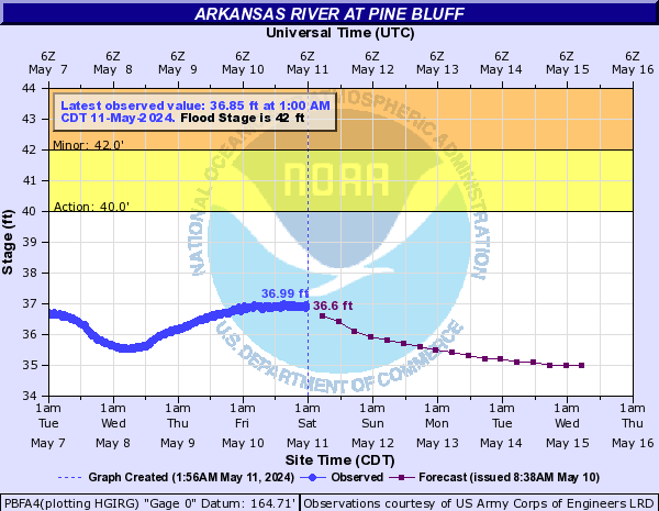
Posted on 5/28/19 at 11:03 pm to rt3
I don’t know how germane to the topic this is, but with all the hyperbolic conversations about the river changing courses and seeking a faster down the channel, why are there large sections of meanders in the Baton Rouge-Donaldsonville area where the river has not cut through them creating shorter path.
Looking at the map below there is one spot where the river narrows very tightly and goes around a large bend.

I know with a high water event like this, these bends between the East and West Bank levees are underwater. So there is water where there are trees in the photo.
Is the USACE doing work around these bends to keep the main channel where it is for navigational purposes?
Looking at the map below there is one spot where the river narrows very tightly and goes around a large bend.
I know with a high water event like this, these bends between the East and West Bank levees are underwater. So there is water where there are trees in the photo.
Is the USACE doing work around these bends to keep the main channel where it is for navigational purposes?
Posted on 5/28/19 at 11:13 pm to Tarps99
quote:
I don’t know how germane to the topic this is, but with all the hyperbolic conversations about the river changing courses and seeking a faster down the channel, why are there large sections of meanders in the Baton Rouge-Donaldsonville area where the river has not cut through them creating shorter path
Why do rivers meander?
Posted on 5/28/19 at 11:15 pm to Tarps99
Those bends get closer and closer over time. The outer edge gets eaten away and the inside edge gets silted in. Left alone, these spots will eventually breach and you’ll end up with an oxbow. Eventually, the mouths of the oxbow will still in enough and they become isolated (lake St. John, etc.) The levees and reinforcing by the USACE keeps these areas from scouring.
In this specific case, if there’s no levee in that location, the river will “straighten out” sooner or later
Just watch the above video
In this specific case, if there’s no levee in that location, the river will “straighten out” sooner or later
Just watch the above video
This post was edited on 5/28/19 at 11:17 pm
Posted on 5/28/19 at 11:27 pm to Tarps99
Back in the day a feller in the "neck" of the bend would have his fieldhands dig a canal in the dead of night to help nature along. Next morning our hero has riverfront property and Donaldsonville is 5 miles away staring at a muddy ditch.

Posted on 5/28/19 at 11:40 pm to slackster
fricking muskrats, it is all their fault.

Posted on 5/28/19 at 11:42 pm to jimbeam
quote:
Eventually, the mouths of the oxbow will still in enough and they become isolated
And the property around them will skyrocket, see False River.
Posted on 5/28/19 at 11:53 pm to Obtuse1
(no message)
This post was edited on 5/29/19 at 12:03 am

Posted on 5/29/19 at 6:03 am to Tarps99
Plaquemine Point will become an oxbow within the next 50-100 years.

 Page 76 of 107

Popular
Back to top