- My Forums
- Tiger Rant
- LSU Recruiting
- SEC Rant
- Saints Talk
- Pelicans Talk
- More Sports Board
- Fantasy Sports
- Golf Board
- Soccer Board
- O-T Lounge
- Tech Board
- Home/Garden Board
- Outdoor Board
- Health/Fitness Board
- Movie/TV Board
- Book Board
- Music Board
- Political Talk
- Money Talk
- Fark Board
- Gaming Board
- Travel Board
- Food/Drink Board
- Ticket Exchange
- TD Help Board
Customize My Forums- View All Forums
- Show Left Links
- Topic Sort Options
- Trending Topics
- Recent Topics
- Active Topics
Started By
Message
re: EBR officials file lawsuit over Iberville aquadams, fear it could could divert flooding
Posted on 7/12/19 at 10:00 pm to FAP SAM
Posted on 7/12/19 at 10:00 pm to FAP SAM
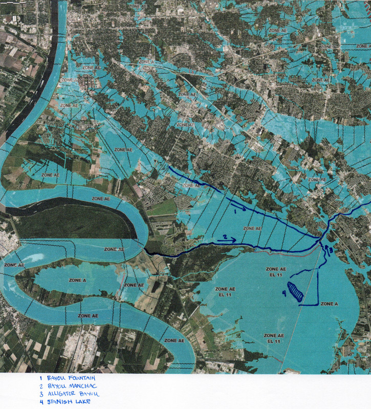
Bayou fountain drains to bayou Manchac. Spanish likes naturally drains into bayou Manchac. Bayou Manchac drains into the Amite River. When Amite starts to be overrun, Manchac overtakes the natural flow of Alligator bayou which drains Spanish lake.
I played a major role in rebuilding the new flood gates at Alligator Bayou/Bayou Manchac. We built the new structure 1’ foot higher than the 2016 flood water got. I know for a fact that the gates are closed so no water from Bayou Manchac will be flowing to Spanish lake. In conclusion, yes the aqua dams are deployed but the new road (which we raised during construction) is significantly higher than the water will get.
I played a major role in rebuilding the new flood gates at Alligator Bayou/Bayou Manchac. We built the new structure 1’ foot higher than the 2016 flood water got. I know for a fact that the gates are closed so no water from Bayou Manchac will be flowing to Spanish lake. In conclusion, yes the aqua dams are deployed but the new road (which we raised during construction) is significantly higher than the water will get.
 3
3

Posted on 7/12/19 at 10:10 pm to topwater30
I have no doubt that the water will not get over the road this time. But that's not gonna stop Mitch from taking a chance to show his constituents that "I'll fight big bad BR for you". And the story will continue running on every news station that every Iberville resident is watching for this entire storm
Posted on 7/12/19 at 10:21 pm to topwater30
The south end of the lake drains into Ascension also and could impacts the Geismar area and plants. While this is an Iberville vs. EBR fight, Ascension is watching closely also.
BTW the new road has some massive crevasses in to do to the sub-base shifting.
BTW the new road has some massive crevasses in to do to the sub-base shifting.

Posted on 7/13/19 at 1:31 pm to topwater30
quote:
Bayou fountain drains to bayou Manchac. Spanish likes naturally drains into bayou Manchac. Bayou Manchac drains into the Amite River. When Amite starts to be overrun, Manchac overtakes the natural flow of Alligator bayou which drains Spanish lake.
I played a major role in rebuilding the new flood gates at Alligator Bayou/Bayou Manchac. We built the new structure 1’ foot higher than the 2016 flood water got. I know for a fact that the gates are closed so no water from Bayou Manchac will be flowing to Spanish lake. In conclusion, yes the aqua dams are deployed but the new road (which we raised during construction) is significantly higher than the water will get.
Below is basically a more detailed/illustrated version of my previous post with additional information backing up my thought process. I understand the typical flow of Bayous Manchac and Fountain, and that Spanish Lake typically drains into Manchac (via Alligator Bayou I believe?). I have also provided additional historic data below that illustrates the natural anatomy and functionality of the Spanish Lake sub-basin.
I appreciate the additional insight and am truly curious as to WHY it is being done the current way. It seems to me that the current solution seems to be literally a divisive solution between two neighboring parishes, that attempts to fight what nature intended for the area connecting the parishes.
I'm no expert by any means in this regard, and my insight is based primarily on what I learned and observed from the 2016 flood. I was fascinated to learn more about Spanish Lake and it's history. My confusion lies primarily in:
1) Why the water control structure was built 1' higher than the 2016 flood water?
2) Why the gates would be closed so that no water will be flowing into Spanish Lake?
3) Why the road (levee) was raised during construction?
Based on my current knowledge the answer to all three above questions are simply to keep water from flowing it's natural course from EBR to Iberville/Ascension via the Spanish Lake sub-basin (and the associated Bluff Swamp sub-basin).
Typical flow of Bayous Fountain, Manchac, and Alligator Bayou including the natural flood plains:
Additional info from Review of Proposed Water Management Plan:
quote:
2.2 Vegetation
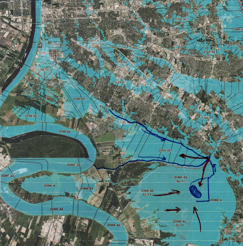
Based on the historical aerial photography, water levels within the Spanish Lake sub-basin were not impounded until after the installation of the water control structure at the confluence of Alligator Bayou and Bayou Manchac. The structure, when closed, impounds surface run-off and floodwater. Prior to installation of the water control structure, water levels within the Spanish Lake sub-basin fluctuated naturally with Bayou Manchac water levels. This pulsed hydrologic regime is what created and supported the healthy forest ecosystem that existed prior to implementation of the Alligator Bayou floodgate. The situation in the Spanish Lake sub-basin contrasts with that of the Bluff Swamp sub-basin, which has retained a more natural flooding regime characterized by regular flooding and draining.
2.4.1 Historic hydrologic data
Historically there were two major hydrologic influences affecting water levels within the Spanish Lake and Bluff Swamp sub-basins, including: 1) surface flow generated from the upland agricultural lands along the Mississippi River conveyed into the Spanish Lake sub-basin via Bayous Braud and Paul; and 2) backwater flooding from Bayou Manchac. There also was occasional flooding of the area by the Mississippi River.
Backwater flooding from Bayou Manchac influences the extent and duration of flooding within the Spanish Lake sub-basin. The bayou merges with the Amite River near Hope Villa, Louisiana, which then discharges into Lake Maurepas. During significant storm events, backwater from the Amite River reverses the flow of Bayou Manchac, which then discharges into all Bayou Manchac’s sub-basins, including the Spanish Lake and Bluff Swamp sub-basins.
Historical Natural Backflow of Spanish Lake sub-basin:
In summary, it seems to me based on the above information that Spanish Lake is the natural backwater reservoir for such flood events. Building up Manchac Road and Alligator Bayou Road as a literal levee, along with creating a floodgate that will remain closed during such flood events has created a complete man-made blockade of the historical natural reservoir that was formed precisely for these scenarios. It just doesn't make any sense to me, so I'm trying to grasp why there's not a better solution. A comparison could be if Ascension built a dam across the Amite and said "We don't want your EBR river water flowing through here!"
Couldn't these same aqua dams be utilized to more safely funnel the excess water into the Spanish Lake basin while protecting as many residents as possible, as opposed to deliberately attempting to form a full blockade to the natural flow from one parish to the next?

 Page 1 of 1


Popular
Back to top